
Dukes Creek facts for kids

Dukes Creek is a beautiful creek located in White County, Georgia. It's famous because gold was discovered there in 1828! This discovery helped start the exciting time known as the Georgia Gold Rush. The creek is approximately 8.76 miles (14.10 km) long.
Where Does Dukes Creek Flow?
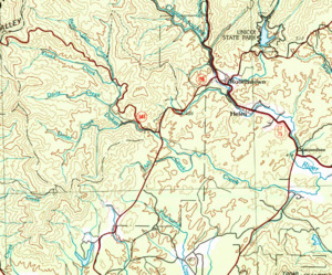

Dukes Creek begins near State Route 348. It starts where two smaller streams, Bear Den Creek and Little Low Gap Branch, meet. This spot is about 2 miles west of Helen.
The creek then flows into the Chattahoochee River. This meeting point is just east of where State Route 17 and State Route 75 cross, southeast of Helen. Along its journey, Dukes Creek gets more water from other streams like Dodd Creek, Dover Creek, and Ash Creek.
Dukes Creek Falls and Hiking Trails
One of the most popular spots along the creek is the 150-foot Dukes Creek Falls. Even though they are called Dukes Creek Falls, they are actually on Davis Creek, right where it joins Dukes Creek.
You can reach these amazing falls by hiking the Dukes Creek Trail. There's a special viewing platform at the falls where you can get a great look. Dukes Creek Falls is one of four popular waterfalls in the Chattahoochee National Forest near Helen, Georgia.
- Two other waterfalls, Anna Ruby Falls and Raven Cliff Falls, are also in White County.
- The third waterfall, DeSoto Falls, is in nearby Lumpkin County.
A part of Dukes Creek is also included in the Smithgall Woods – Dukes Creek Conservation Area. This area helps protect the natural beauty of the creek and its surroundings.
Understanding the Dukes Creek Area

The area that drains water into Dukes Creek is called its watershed. The United States Geological Survey (USGS) has given this specific watershed a special code: HUC 031300010103.
This area is known as the Dukes Creek sub-watershed. It covers about 22 square miles. This land is located west and south of Helen, and also west and south of where the Chattahoochee River begins.
