Dumbarton (district) facts for kids
| Dumbarton | |
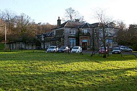
 Council's headquarters: Crosslet House, Dumbarton |
|
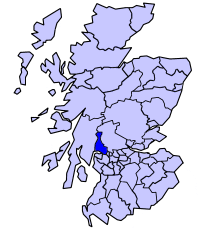
 Dumbarton district within Scotland |
|
| Geography | |
| HQ | Dumbarton |
| History | |
| Created | 16 May 1975 |
| Abolished | 31 March 1996 |
| Succeeded by | (Part of) West Dunbartonshire (Part of) Argyll and Bute |
Quick facts for kids Demography |
|
|---|---|
| 1994 population | 77,222 |
| Politics | |
| Governance | Dumbarton District Council |
Dumbarton (Scottish Gaelic: Dùn Breatainn) was a special area in Scotland that had its own local government from 1975 to 1996. It was one of nineteen districts in the Strathclyde region. This area included the town of Dumbarton and the places around it, located north-west of Glasgow.
Contents
History of Dumbarton District
The Dumbarton district was created in 1975. This happened because of a new law called the Local Government (Scotland) Act 1973. This law set up a new way for local areas to be governed across mainland Scotland.
There were two levels of government:
- Bigger areas called regions.
- Smaller areas called districts within those regions.
Dumbarton became one of nineteen districts inside the Strathclyde region. The new district took over areas from six older districts and towns. These older areas were all closed down at the same time.
- Cove and Kilcreggan Burgh (a small town)
- Dumbarton Burgh
- Helensburgh Burgh
- Helensburgh District
- Part of Old Kilpatrick District (specifically Bowling and Dunbarton areas)
- Vale of Leven District
The main towns in the Dumbarton district were Dumbarton itself and the nearby Vale of Leven settlements. Also important were Helensburgh and other coastal villages along the Firth of Clyde. Further west, the land became more mountainous and had fewer people.
The western border of the district was the middle of Loch Long. The eastern border was the middle of Loch Lomond. However, the area south of the Endrick Water was fully part of Dumbarton. Much of the eastern border was next to Stirling district. The smaller Clydebank district was to the south-east. In 1983, the village of Croftamie moved from Dumbarton district to Stirling district.
How Dumbarton District Changed
Dumbarton district was closed down in 1996. This was due to another new law, the Local Government etc. (Scotland) Act 1994. This law changed Scotland's local government again. It replaced regions and districts with single-level council areas.
Before this change, people in the district voted on what they wanted to happen. The more rural western part, including Helensburgh, voted to join Argyll and Bute. They did not want to stay with Dumbarton.
So, the district was split. The part that went to Argyll and Bute was west of a line from Cameron House at Loch Lomond to the Firth of Clyde. The rest of Dumbarton district joined with the nearby Clydebank district. Together, they became the West Dunbartonshire council area.
The new law first called this new area "Dumbarton and Clydebank." But the local leaders chosen in 1995 asked for a different name. They wanted it to be called "West Dunbartonshire," and the government agreed. This new council area started operating in 1996.
Political Control of Dumbarton District
The first election for the Dumbarton district council happened in 1974. The council started its work officially on May 16, 1975. The table below shows which political party or group was in charge of the council from 1975 onwards.
| Party in control | Years | |
|---|---|---|
| Labour | 1975–1977 | |
| No overall control | 1977–1980 | |
| Labour | 1980–1988 | |
| No overall control | 1988–1996 | |
District Council Elections
Elections for the Dumbarton District Council were held several times. The table below shows how many seats each main political party won in those elections.
| Year | Seats | Labour | Conservative | SNP | Alliance | Independent / Other | Notes |
|---|---|---|---|---|---|---|---|
| 1974 | 15 | 9 | 4 | 0 | 0 | 4 | |
| 1977 | 15 | 3 | 5 | 4 | 0 | 3 | |
| 1980 | 15 | 9 | 3 | 1 | 0 | 2 | |
| 1984 | 16 | 11 | 2 | 0 | 1 | 2 | |
| 1988 | 16 | 7 | 4 | 3 | 0 | 2 | |
| 1992 | 16 | 8 | 5 | 2 | 0 | 1 | |
Council Buildings
The Dumbarton district council set up its main offices at Crosslet House. This was a large Victorian house on Argyll Avenue in Dumbarton.
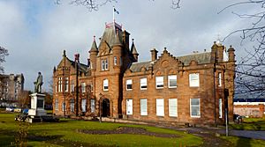
The council also took over the Municipal Buildings. These buildings were in the center of Dumbarton. They had been built in 1903. The district council used the council chamber there for meetings. Other parts of the building were used as extra office space.
Both Crosslet House and the Municipal Buildings were passed to the new West Dunbartonshire Council in 1996. Crosslet House was later taken down in 2015.
See also
 | John T. Biggers |
 | Thomas Blackshear |
 | Mark Bradford |
 | Beverly Buchanan |


