Dumfries, Virginia facts for kids
Quick facts for kids
Dumfries, Virginia
|
||
|---|---|---|
| Town of Dumfries | ||
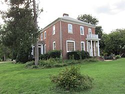
Henderson House
|
||
|
||
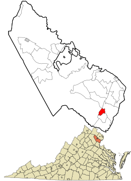
Location in Prince William County and the state of Virginia
|
||
| Country | ||
| State | ||
| County | Prince William | |
| Founded | 1749 | |
| Area | ||
| • Total | 1.55 sq mi (4.02 km2) | |
| • Land | 1.53 sq mi (3.98 km2) | |
| • Water | 0.02 sq mi (0.05 km2) | |
| Elevation | 36 ft (11 m) | |
| Population
(2010)
|
||
| • Total | 4,961 | |
| • Estimate
(2019)
|
5,922 | |
| • Density | 3,857.98/sq mi (1,489.58/km2) | |
| Time zone | UTC−5 (Eastern (EST)) | |
| • Summer (DST) | UTC−4 (EDT) | |
| ZIP Code |
22026
|
|
| Area code(s) | 571, 703 | |
| FIPS code | 51-23760 | |
| GNIS feature ID | 1499362 | |
Dumfries, officially called the Town of Dumfries, is a historic town in Prince William County, Virginia. In 2010, about 4,961 people lived there. It is known as the oldest continuously chartered town in Virginia.
Contents
Where is Dumfries Located?
Dumfries is located at 38°34′4″N 77°19′29″W / 38.56778°N 77.32472°W. It covers about 1.6 square miles (4.1 square kilometers) of land. The town is about 70 miles north of Richmond, the state capital. It is also about 30 miles south of Washington, D.C..
A Look Back: The History of Dumfries
The story of Dumfries began around 1690. That's when Richard Gibson built a gristmill (a mill for grinding grain) on Quantico Creek. Soon after, in 1731, a customhouse and warehouse were built. More buildings appeared along the water by 1732.
Founding the Town
The Town of Dumfries was officially created on 60 acres of land. This land was given by John Graham. He named the town after his hometown, Dumfries, Scotland. On May 11, 1749, Dumfries received its official charter. This made it the oldest town in Virginia that has continuously had its charter.
The Town Seal
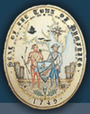
The official seal of Dumfries tells its history. It shows things from when the first settlers arrived in 1651. They saw how useful the harbor in Quantico Creek was. The seal's design includes a rope and an anchor chain. These are like those used on ships from the Colonial era.
Inside the seal, you can see items related to a town by the sea. There's a map of the Chesapeake Bay and the Potomac River. Dumfries is marked at the top of Quantico Creek. Tools like a sextant and compass rose are also shown. These were used for navigation.
The seal also features two water birds, representing the wetlands. A dock with a fishing net and ship parts show it was a busy port. A thistle flower represents the Scottish founders. John Graham, who founded the town, chose the name Dumfries to honor his home in Scotland.
The shield on the seal has two figures. On the left is a Piscataway brave. This was a main Native American tribe in the area. On the right is a Colonial militiaman from 1775. The shield also shows a sailing ship and a tobacco leaf. Tobacco was the first main product of the town. Later, wheat became important.
A Thriving Port Town
Dumfries became the second most important port in Colonial America for tobacco. It was as busy as big cities like New York and Philadelphia. The town was at its busiest and most important around 1763. For about 15 years, Dumfries was a very active port.
However, several things caused its decline. The American Revolutionary War played a part. Also, the creek became filled with dirt and mud (called siltation). This made it harder for ships to use the port. Finally, the main products being shipped changed from tobacco to wheat and sugar.
Important Places and People
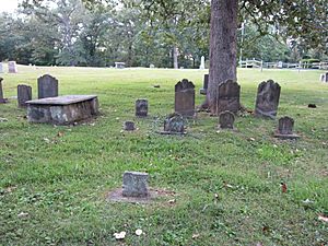
The Dumfries Cemetery is where some of the town's first settlers are buried. Alexander Henderson was a merchant when the port was busy. He built the Henderson House, which you can still see today. His son, Archibald Henderson, became a famous leader of the United States Marine Corps.
Other historic places in Dumfries are listed on the National Register of Historic Places. These include the Leesylvania Archeological Site (44PW7), the Old Hotel, and the Weems-Botts Museum.
Population of Dumfries
| Historical population | |||
|---|---|---|---|
| Census | Pop. | %± | |
| 1860 | 171 | — | |
| 1870 | 167 | −2.3% | |
| 1880 | 132 | −21.0% | |
| 1900 | 160 | — | |
| 1910 | 158 | −1.2% | |
| 1920 | 182 | 15.2% | |
| 1930 | 157 | −13.7% | |
| 1940 | 480 | 205.7% | |
| 1960 | 1,368 | — | |
| 1970 | 1,890 | 38.2% | |
| 1980 | 3,214 | 70.1% | |
| 1990 | 4,282 | 33.2% | |
| 2000 | 4,937 | 15.3% | |
| 2010 | 4,961 | 0.5% | |
| 2019 (est.) | 5,922 | 19.4% | |
| U.S. Decennial Census | |||
In 2000, about 4,937 people lived in Dumfries. There were 1,573 households. Many households had children under 18. The average age of people in Dumfries was 29 years old. By 2019, the population was estimated to be around 5,922 people.
Getting Around Dumfries
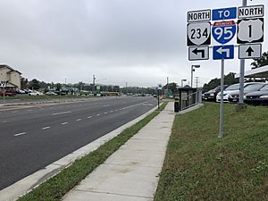
The main road for getting to Dumfries is U.S. Route 1. Other important roads nearby include Virginia State Route 234 and Interstate 95.
Famous People from Dumfries
- George Graham (soldier) - He was a temporary U.S. Secretary of War.
- Alexander Henderson - A well-known merchant.
- Kendall Marshall - A professional basketball player.
- Ali Krieger - A professional soccer player.
- Mason Locke Weems - He wrote a biography about George Washington.
- Asa Blanchard - A famous silversmith from Kentucky.
See also
 In Spanish: Dumfries (Virginia) para niños
 | Sharif Bey |
 | Hale Woodruff |
 | Richmond Barthé |
 | Purvis Young |


