Dumoine River facts for kids
Quick facts for kids Dumoine River |
|
|---|---|

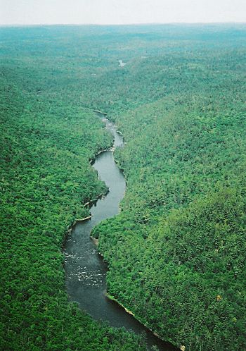
Dumoine River near river kilometer 55
|
|
| Native name | Rivière Dumoine |
| Country | Canada |
| Province | Quebec |
| Regions |
|
| Physical characteristics | |
| Main source | Machin Lake Réservoir-Dozois, Quebec 47°16′19″N 77°53′0″W / 47.27194°N 77.88333°W |
| River mouth | Ottawa River west of Rapides-des-Joachims 46°12′55″N 77°50′57″W / 46.21528°N 77.84917°W |
| Length | 129 km (80 mi) |
| Basin features | |
| Progression | Ottawa River→ Saint Lawrence River→ Gulf of Saint Lawrence |
| River system | Ottawa River drainage basin |
| Basin size | 5,380 km2 (2,080 sq mi) |
The Dumoine River is a beautiful river in western Quebec, Canada. It starts at Machin Lake and flows south into the Ottawa River. This river is about 129 kilometres (80 mi) long. It drains an area of 5,380 square kilometres (2,080 sq mi). This means the river has a strong current and many fast-moving sections called rapids.
Today, the Dumoine River is famous for its exciting whitewater canoeing and great fishing. It has a long history, from the time of the native people to early explorers and fur traders. There are not many buildings or towns along the river. You might see a few logging roads or cottages in some spots.
The Dumoine River is often compared to the Noire River and the Coulonge River. These three rivers are in the same area. They share similar features and are very popular with whitewater canoers. The river gets its name from a French family called Le Moynes.
For most of its length, the Dumoine River forms the border between two areas. These areas are the Pontiac and Témiscamingue regional county municipalities.
River History: A Journey Through Time
The Algonquins, who are native to this land, had two names for the river. They called it Cakawitopikak Sipi, meaning Alder River. This is because many alder trees grow along its banks. They also called it Ekonakwasi Sipi, which means Desire River. Old maps from the 1700s show similar names for the river.
Native people used the Dumoine River as an important travel route. They came from the Great Lakes area. They would travel by canoe and carry their canoes over land (called portages) between lakes and rivers. This route helped them reach trading partners in other parts of Quebec. It also helped them avoid areas where there might be conflict.
In 1762, an explorer named Alexander Henry the elder visited the mouth of the Dumoine. He wrote about finding a small camp of Maskegon Indians there. He traded many items with them for fur. Later, a trading post called Fort Dumoine was built near the river's mouth. This post was important for fur trading for many years.
In 2008, the Quebec government decided to protect a large part of the Dumoine River area. This protected area covers almost a third of the river's watershed. It means that industrial activities, like logging, are not allowed there. This helps keep the river and its surroundings natural and healthy.
Paddling Adventures on the Dumoine
Paddling down the Dumoine River is a thrilling experience for canoeists. The river has many runnable rapids and a fast, steady current. Most trips start at Lac Dumoine and last about 5 to 7 days. You can also start at Lac Laforge for a 4-day trip or Lac Benoit for a 3 to 4-day trip. People usually reach these starting points by float plane or logging road.
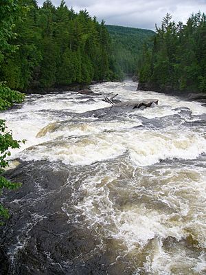
The rapids on the Dumoine River vary a lot. Some are easy, fast-moving sections called swifts. Others are powerful waterfalls that you cannot canoe down. Here are some of the well-known rapids:
- Fish Portage (also called "Triple Play") at km 64: This spot has three sets of falls. The approaches are rated Class 1 and 2, meaning they are exciting but manageable.
- Canoe Eater at km 58: This is a fun, technical section with many boulders. It's a Class 2 rapid.
- Log Jam at km 55
- Little Steel at km 54
- Big Steel at km 44: This is a Class 3 to 2 rapid, offering a good challenge.
- Grande Chute at km 23: This is an impressive waterfall that cannot be canoed. It's followed by a Class 1 rapid.
- Red Pine at km 17: This is a series of rapids ranging from Class 1 to 3.
- Examination at km 13
The section between Lac Benoit and Little Steel Falls (kilometres 60 to 50) is especially exciting. It has many Class 2-3 rapids. These are typical of rivers in the Canadian Shield region. They often feature a drop followed by a calm pool.
The very last waterfall on the river is called Ryan's Chute. It connects to the Ottawa River. This chute was once very dangerous for loggers. There were even memorials to those who drowned there.
All the major rapids and falls have well-kept portages. A portage is a path where you carry your canoe and gear around a difficult section of the river. For some smaller rapids, it's a good idea to have someone watch ahead. This helps you find the portages safely, especially near dangerous waters.
When you finish your trip, you'll be on the Quebec side of the Ottawa River. This area is undeveloped. You can cross the Ottawa River to Driftwood Provincial Park in Ontario. Or you can paddle about 12 kilometres (7 mi) downstream to Rapides-des-Joachims, Quebec. The Ottawa River can be very windy with large waves, so always be careful.
Many excellent guide maps and books are available for the Dumoine River. They provide detailed descriptions and drawings of each rapid. This helps paddlers plan their trips safely and enjoyably.
 | DeHart Hubbard |
 | Wilma Rudolph |
 | Jesse Owens |
 | Jackie Joyner-Kersee |
 | Major Taylor |


