
Noire River (Ottawa River tributary) facts for kids
Quick facts for kids Noire River |
|
|---|---|

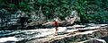
Black River Inn on the lower Noire River
|
|
| Native name | Rivière Noire |
| Other name(s) | Black River |
| Country | Canada |
| Province | Quebec |
| Region | Outaouais |
| District | Pontiac RCM |
| Physical characteristics | |
| Main source | Unnamed location Lac-Nilgaut, Quebec 46°56′20″N 77°26′32″W / 46.93889°N 77.44222°W |
| River mouth | Ottawa River Waltham, Quebec 45°54′26″N 76°56′37″W / 45.90722°N 76.94361°W |
| Length | 238 km (148 mi) |
| Basin features | |
| Progression | Ottawa River→ Saint Lawrence River→ Gulf of Saint Lawrence |
| River system | Ottawa River drainage basin |
| Basin size | 2,668 km2 (1,030 sq mi) |
The Noire River is a river in western Quebec, Canada. Its name means "Black River" in French, which is also another common name for it. The river flows southeast and joins the Ottawa River near Waltham, Quebec. It gets its name from the dark color of its water.
The Noire River is often compared to the Dumoine and Coulonge Rivers. These three rivers are in the same area. They share similar features and are very popular for whitewater canoeing.
Contents
River's Journey: Where the Noire River Flows
The Noire River starts in a wild, unnamed area just south of the La Vérendrye Wildlife Reserve. It flows through the Canadian Shield in Quebec. This area has many rocks. The river has parts with fast-moving, rocky whitewater. It also has calmer sections that wind through sandy valleys.
Trees Along the River
Many types of trees grow along the Noire River. You can find Black Spruce, Jack Pine, Eastern White Pine, and Red Pine. Other common plants include juniper, alder, and birch.
Most of the river is untouched by development. However, the last 30 km (19 mi) of the river is different. Here, you will see cottages and even an inn along the riverbanks. Close to where it meets the Ottawa River, there is a dam with a power station.
Paddling Adventures on the Noire River
The Noire River is a great place for canoeing. You can start paddling where it meets Coughlin Creek. This spot is about 237 kilometers (147 mi) from the river's end. From here, most of the rapids are Class 1 or 2. These ratings are for medium water levels. About 27 kilometres (17 mi) of the river has exciting whitewater rapids.
Famous Rapids on the Noire River
Some well-known rapids on the Noire River include:
- km 114, "The Wall" - This is a Class 2 rapid that requires careful paddling.
- km 100, "Targie" - This rapid changes from a Class 3 to a Class 2.
- km 51, "50-50" - This is a Class 3 rapid.
- km 40 to 30 - This section has continuous Class 1 rapids and fast-moving water. This is true unless the water levels are very low.
Portaging Around Obstacles
Sometimes, paddlers need to carry their canoes around difficult spots. This is called a portage. One important portage is around Mountain Chute. You can choose a long, tough path over rough ground. Or, you can take a shorter route that starts at the top of the falls. This shorter path ends with a very steep drop, so you need ropes to get down safely.
Hydroelectric Power: How the River Makes Electricity
The Noire River has been used to create hydroelectric power for a long time. This means using the force of flowing water to make electricity. It is believed that the Noire River had the first commercial power station in Canada. This happened at the beginning of the 20th century.
The Dam and Power Station
A large concrete dam was built on the river in 1937. It was updated in 1994. The dam is 11.7 metres (38 ft) high and 106.4 metres (349 ft) long. It can hold a lot of water. The dam and the W.R. Beatty Generating Station are near the river's mouth. They are located at the end of Robinson Lake. This station generates 10.6 megawatts of power.
Over the years, the ownership of the power station has changed. It was first owned by the Pembroke Electric Light Company. Then, the Pontiac Hydro Commission took over. In 1996, Brookfield Power bought it.
Images for kids
-
The Noire River flowing through the landscape.
