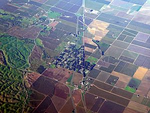
Dunnigan, California facts for kids
Quick facts for kids
Dunnigan
|
|
|---|---|

Aerial view of Dunnigan in December 2021
|
|
| Country | |
| State | |
| County | Yolo County |
| Area | |
| • Total | 5.23 sq mi (13.55 km2) |
| • Land | 5.23 sq mi (13.55 km2) |
| • Water | 0.00 sq mi (0.00 km2) 0% |
| Elevation | 69 ft (21 m) |
| Population | |
| • Total | 1,382 |
| • Density | 264.14/sq mi (101.98/km2) |
| ZIP code |
95937
|
| Area code | 530 |
| FIPS code | 06-20228 |
| GNIS feature IDs | 222740, 2583003 |
Dunnigan, once known as Antelope, is a small community in Yolo County, California. It is located right along Interstate 5. In 2010, about 1,416 people lived here. Dunnigan is about 69 feet (21 meters) above sea level. Its ZIP code is 95937 and its area code is 530.
Contents
History of Dunnigan
The town of Dunnigan was first started by two early settlers, J. S. Copp and Jolin Wilson, in 1853. They originally lived closer to the Sacramento River. However, a big winter flood pushed them to higher ground, where they decided to settle.
The next year, A. W. Dunnigan arrived and gave his name to the place. He opened a hotel with Henry Yarick, which was known as "Dunnigan's Inn." Other early neighbors included Irving W. and William Brownell, Isaac Rice, D. T. Bird, Harry Porterfield, and M. A. Rahm.
The first store in Dunnigan opened in 1866, started by G. B. Lewis. Later, William Earll took over the store. In 1876, the railroad came through the town. This led to the official town map of Dunnigan being recorded on November 1 of that year. A post office also opened in 1856, and its name was changed from Antelope to Dunnigan in 1876.
Geography of Dunnigan
Dunnigan is located in a central part of California. It is about 11 miles (18 km) from Arbuckle. It is also nearly 40 miles (64 km) from both Vacaville and Sacramento.
The community covers an area of about 5.2 square miles (13.2 square kilometers). All of this area is land, with no water.
Climate in Dunnigan
Dunnigan has a type of weather called a warm-summer Mediterranean climate. This means it has hot, dry summers and mild, wet winters. This climate is common in California.
Population and People
| Historical population | |||
|---|---|---|---|
| Census | Pop. | %± | |
| 2020 | 1,382 | — | |
| U.S. Decennial Census | |||
In 2010, the population of Dunnigan was 1,416 people. This means there were about 271 people living in every square mile.
Who Lives in Dunnigan?
The people living in Dunnigan come from many different backgrounds. In 2010, about 59% of the population was White. About 7.6% were African American, and 1.8% were Native American. About 1.3% were Asian, and a small number were Pacific Islander.
Many residents were from other racial backgrounds, and about 6.3% identified as being of two or more races. A significant portion, about 41.2%, identified as Hispanic or Latino.
There were 504 households in Dunnigan in 2010. About 32.7% of these households had children under 18 living in them. The average household had about 2.81 people.
The population included people of all ages. About 25.6% were under 18 years old. About 19.8% were 65 years or older. The median age in Dunnigan was 41.7 years.
Many homes in Dunnigan are owned by the people who live in them. About 80.8% of the homes were owner-occupied in 2010.
Changes Over Time
In 2000, Dunnigan had a population of 897 people. The community has grown since then. The median income for a household in 2000 was $28,833.
Since the early 2000s, new homes have been built in the Dunnigan area. Many of these new homes are located east of Interstate 5. People are often interested in Dunnigan because it offers larger land lots at more affordable prices compared to the nearby Sacramento area.
See also
 In Spanish: Dunnigan para niños
 | Tommie Smith |
 | Simone Manuel |
 | Shani Davis |
 | Simone Biles |
 | Alice Coachman |


