Durand, Michigan facts for kids
Quick facts for kids
Durand, Michigan
|
|
|---|---|
| City of Durand | |

|
|
| Nickname(s):
Railroad City, USA
|
|

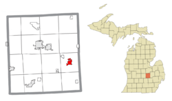
Location within Shiawassee County
|
|
| Country | United States |
| State | Michigan |
| County | Shiawassee |
| Platted | 1836 |
| Incorporated | 1887 (village) 1932 (city) |
| Government | |
| • Type | Council–manager |
| Area | |
| • Total | 1.95 sq mi (5.06 km2) |
| • Land | 1.95 sq mi (5.06 km2) |
| • Water | 0.00 sq mi (0.00 km2) |
| Elevation | 794 ft (242 m) |
| Population
(2020)
|
|
| • Total | 3,507 |
| • Density | 1,795.70/sq mi (693.16/km2) |
| Time zone | UTC-5 (Eastern (EST)) |
| • Summer (DST) | UTC-4 (EDT) |
| ZIP code(s) |
48429
|
| Area code(s) | 989 |
| FIPS code | 26-23500 |
| GNIS feature ID | 1626198 |
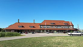
Durand (pronounced doo-RAND) is a city in Shiawassee County, in the state of Michigan. In 2020, about 3,507 people lived there. Durand is often called "Railroad City, USA" because of its important train station. This station was a big center for trains for many years. Today, Amtrak passenger trains still use it. Also, three different companies use the city's train yard to move goods.
Contents
Exploring Durand's Past: A Brief History
Durand was first called Vernon Center. It was planned out in 1836. The city got its current name from George H. Durand, a congressman from Flint, Michigan. Durand became a village in 1887. Later, in 1932, it officially became a city.
In the past, the railroad was very important to Durand. Children loved watching the trains. It was a big part of daily life in the town.
Where is Durand Located?
Durand is located in Michigan. The city covers an area of about 2.11 square miles (5.46 square kilometers). Most of this area is land, with a very small amount of water.
Who Lives in Durand?
| Historical population | |||
|---|---|---|---|
| Census | Pop. | %± | |
| 1880 | 210 | — | |
| 1890 | 255 | 21.4% | |
| 1900 | 2,134 | 736.9% | |
| 1910 | 2,315 | 8.5% | |
| 1920 | 2,672 | 15.4% | |
| 1930 | 3,081 | 15.3% | |
| 1940 | 3,127 | 1.5% | |
| 1950 | 3,194 | 2.1% | |
| 1960 | 3,312 | 3.7% | |
| 1970 | 3,678 | 11.1% | |
| 1980 | 4,206 | 14.4% | |
| 1990 | 4,283 | 1.8% | |
| 2000 | 3,933 | −8.2% | |
| 2010 | 3,446 | −12.4% | |
| 2020 | 3,507 | 1.8% | |
| U.S. Decennial Census | |||
Durand's Population in 2010
In 2010, there were 3,446 people living in Durand. These people lived in 1,350 homes. About 852 of these homes were families. The city had about 1,575 housing units in total.
Many homes (35%) had children under 18 living there. About 42.5% of homes were married couples. The average home had 2.45 people. The average family had 3.08 people.
The average age of people in Durand was 37.2 years old. About 25.8% of residents were under 18. Also, 15.7% were 65 years old or older.
How to Get Around Durand: Roads and Rails
Major Roads and Highways
- I-69 runs along the northwest edge of Durand.
- M-71 is another state highway. It ends near I-69, just outside the city.
Important Train Lines
Trains are a very big part of Durand's story.
- Amtrak is the national passenger train system. It offers daily trips on the Blue Water route. This route connects Chicago to Port Huron, Michigan.
- Amtrak trains stop at the famous Durand Union Station. This station is where major train lines meet. These lines go east to Port Huron and Toronto, and west to Chicago. Other lines go north to Elberta, Michigan, and south to Toledo, Ohio.
- Several freight train companies also use Durand. These include Canadian National Railway (CN), Huron and Eastern Railway (HESR), and Great Lakes Central Railroad (GLC). They help move goods across the country.
See also
 In Spanish: Durand (Míchigan) para niños
 | Janet Taylor Pickett |
 | Synthia Saint James |
 | Howardena Pindell |
 | Faith Ringgold |


