Durbin, West Virginia facts for kids
Quick facts for kids
Durbin, West Virginia
|
|
|---|---|

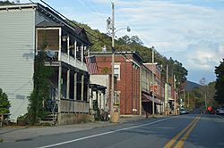
Main Street commercial district
|
|

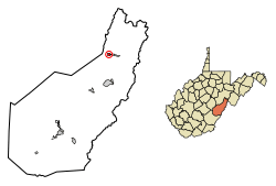
Location of Durbin in Pocahontas County, West Virginia.
|
|
| Country | United States |
| State | West Virginia |
| County | Pocahontas |
| Area | |
| • Total | 0.57 sq mi (1.48 km2) |
| • Land | 0.57 sq mi (1.48 km2) |
| • Water | 0.00 sq mi (0.00 km2) |
| Elevation | 2,738 ft (835 m) |
| Population
(2020)
|
|
| • Total | 235 |
| • Estimate
(2021)
|
240 |
| • Density | 513.99/sq mi (198.44/km2) |
| Time zone | UTC-5 (Eastern (EST)) |
| • Summer (DST) | UTC-4 (EDT) |
| ZIP code |
26264
|
| Area code(s) | 304 |
| FIPS code | 54-22852 |
| GNIS feature ID | 1550996 |
| Website | https://www.welcometodurbinwv.com/ |
Durbin is a small town located in Pocahontas County, West Virginia, in the United States. It's a quiet place with a population of 235 people, according to the 2020 United States Census.
The town got its name in 1895. It was named after Charles R. Durbin Sr. He was a bank official from Grafton, West Virginia. Mr. Durbin helped John T. McGraw buy the land for the town in 1890 by lending him money.
Contents
Where is Durbin Located?
Durbin is found in the northern part of Pocahontas County. It sits right where two rivers meet: the East Fork and West Fork of the Greenbrier River. This meeting point is actually where the Greenbrier River officially begins!
The town covers a total area of about 0.57 square miles (1.48 square kilometers). All of this area is land, with no large bodies of water inside the town limits.
How Many People Live in Durbin?
The number of people living in Durbin has changed over the years. Here's a look at the population counts from different census years:
| Historical population | |||
|---|---|---|---|
| Census | Pop. | %± | |
| 1910 | 390 | — | |
| 1920 | 422 | 8.2% | |
| 1930 | 498 | 18.0% | |
| 1940 | 533 | 7.0% | |
| 1950 | 540 | 1.3% | |
| 1960 | 431 | −20.2% | |
| 1970 | 347 | −19.5% | |
| 1980 | 379 | 9.2% | |
| 1990 | 278 | −26.6% | |
| 2000 | 262 | −5.8% | |
| 2010 | 293 | 11.8% | |
| 2020 | 235 | −19.8% | |
| 2021 (est.) | 240 | −18.1% | |
| U.S. Decennial Census | |||
Durbin's Population in 2010
In 2010, there were 293 people living in Durbin. These people lived in 124 different homes. About 78 of these homes were families.
The town had about 514 people per square mile. This is called the population density. There were also 174 housing units, which are places where people can live.
Most of the people living in Durbin were White (96.9%). A small number were Native American (0.3%) or from other backgrounds. About 3.8% of the population was Hispanic or Latino.
In the homes, about 29% had children under 18 living there. Nearly half (48.4%) were married couples. Some homes had a single parent, either a mother (8.9%) or a father (5.6%). About 37% of homes were not families, meaning they might be single people living alone.
The average number of people in a home was 2.36. For families, the average was 2.90 people.
The average age of people in Durbin was 45.1 years old. About 20.8% of residents were under 18. About 21.5% were 65 years old or older. The town had a nearly equal number of males (50.2%) and females (49.8%).
See also
 | Toni Morrison |
 | Barack Obama |
 | Martin Luther King Jr. |
 | Ralph Bunche |


