East Branch Christina River facts for kids
Quick facts for kids East Branch Christina River |
|
|---|---|
| Other name(s) | Tributary to Christina River |
| Country | United States |
| State | Delaware Maryland Pennsylvania |
| County | New Castle (DE) Cecil (MD) Chester (PA) |
| Physical characteristics | |
| Main source | Christina River divide about 0.25 miles northwest of Strickersville, Pennsylvania 375 ft (114 m) 39°44′18″N 075°48′20″W / 39.73833°N 75.80556°W |
| River mouth | Christina River Covered Bridge Farms, Delaware 161 ft (49 m) 39°42′02″N 075°47′09″W / 39.70056°N 75.78583°W |
| Length | 2.96 mi (4.76 km) |
| Basin features | |
| Progression | south-southeast |
| River system | Christina River |
| Basin size | 2.03 square miles (5.3 km2) |
| Tributaries |
|
| Bridges | Strickersville Road, Elbow Lane, Little Egypt Road, Harvest Lane, Wedgewood Road, Covered Bridge Lane |
The East Branch Christina River is a small river, about 2.96-mile-long (4.76 km), located in the United States. It's a "tributary," which means it's a smaller stream or river that flows into a larger one. This river flows into the Christina River in New Castle County, Delaware.
Where Does the River Flow?
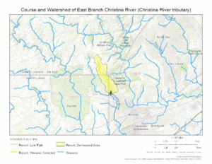
The East Branch Christina River begins in Chester County, Pennsylvania. It starts near a high area called the Christina River divide. A "divide" is like a ridge of high ground that separates different river systems.
From there, the river flows south into Cecil County, Maryland. Then, it turns and flows southeast into New Castle County, Delaware. Finally, it joins the main Christina River at a place called Covered Bridge Farms.
What is a River's Watershed?
Every river has a "watershed," which is the entire area of land where all the rain and snowmelt drain into that river or its smaller streams. Think of it like a giant funnel that collects water for the river.
The East Branch Christina River's watershed covers about 2.03 square miles (5.3 km2) of land. This area gets a good amount of rain each year, about 46.3 inches. About 36.7% of this land is covered by forests.
River Maps
 | Jackie Robinson |
 | Jack Johnson |
 | Althea Gibson |
 | Arthur Ashe |
 | Muhammad Ali |


