
East Chicago, Indiana facts for kids
Quick facts for kids
East Chicago, Indiana
|
|||
|---|---|---|---|
|
|
|||
|
|||
| Nicknames:
Indiana Harbor, The Harbor, E.C., The Twin City (East Chicago & Indiana Harbor neighborhoods – used in the early 1900s).
|
|||
| Motto(s):
"Progredemur" (We Progress)
and A City of Hope and Progress |
|||

Location of East Chicago in Lake County, Indiana.
|
|||
| Country | |||
| State | |||
| County | Lake | ||
| Township | North | ||
| Incorporated (Town) | 1889 | ||
| Incorporated (City) | 1893 | ||
| Government | |||
| • Type | Mayor-Council | ||
| Area | |||
| • Total | 14.86 sq mi (38.50 km2) | ||
| • Land | 14.18 sq mi (36.71 km2) | ||
| • Water | 0.69 sq mi (1.78 km2) | ||
| Elevation | 587 ft (179 m) | ||
| Population
(2020)
|
|||
| • Total | 26,370 | ||
| • Density | 1,860.32/sq mi (718.29/km2) | ||
| Standard of living (2008-12) | |||
| • Per capita income | ,457 | ||
| • Median home value | ,800 | ||
| Time zone | UTC-6 (Central) | ||
| • Summer (DST) | UTC-5 (Central) | ||
| ZIP code |
46312
|
||
| Area code | 219 | ||
| FIPS code | 18-19486 | ||
| GNIS feature ID | 2394597 | ||
| Interstate, U.S. and State Routes | |||
| Waterways | Grand Calumet River Indiana Harbor and Ship Canal Lake Michigan |
||
| South Shore Line station | East Chicago
|
||
| Public transit | East Chicago Transit | ||
| Website | www.eastchicago.com | ||


East Chicago is a city in Lake County, Indiana, United States. It's known for its big industries and is home to the Indiana Harbor and Ship Canal, which is a busy waterway for factories. The city is located right by Lake Michigan, about 18 miles (29 km) from downtown Chicago.
Contents
History of East Chicago
East Chicago got its name because it is located east of the big city of Chicago. A post office opened here in 1889. The city officially became a city in 1893.
The Indiana Harbor Public Library and the Marktown Historic District are important historical places in East Chicago. They are listed on the National Register of Historic Places.
For over 100 years, from 1893 to 1998, the Inland Steel Company was a major business in East Chicago.
Environmental Concerns in East Chicago
In 2009, it was found that some parts of East Chicago had lead and arsenic in the soil. This area was named the USS Lead Superfund Site. A Superfund site is a place with dangerous waste that needs to be cleaned up.
In 2016, tests confirmed these concerns, especially for families living in the West Calumet Housing Complex. The Governor of Indiana declared a disaster emergency to help deal with the situation.
Geography of East Chicago
East Chicago covers about 16 square miles (41 square kilometers). Most of this area is land, but about 2 square miles (5 square kilometers) is water. This includes parts of Lake Michigan and the Indiana Harbor and Ship Canal.
People of East Chicago (Demographics)
In 2010, about 29,698 people lived in East Chicago. The city is home to many different groups of people. About 42.9% were African American, 35.5% were White, and 50.9% of the population was Hispanic or Latino.
Many households (40.8%) had children under 18 living there. The average age of people in the city was about 30.9 years old.
Getting Around East Chicago (Transportation)
If you want to fly, the closest major airport with passenger flights is Chicago Midway Airport. The Gary/Chicago International Airport is closer but does not have regular passenger service.
You can also travel by train. The South Shore Line has a station in East Chicago. For longer train trips, Amtrak service is available nearby at the Hammond-Whiting station.
Major roads like US 12 and US 20 pass through the city. Indiana State Road 912, also called the Cline Avenue Expressway, helps connect East Chicago to other highways and important places like the casino and steel mills.
East Chicago Bus Services
The city has its own free bus service called East Chicago Transit. It has three different routes to help people get around town. Other bus services, like GPRT and PACE, also have routes that connect East Chicago to nearby cities and even to a large UPS facility for workers.
Neighborhoods in East Chicago
East Chicago is made up of several neighborhoods, each with its own character. They are generally grouped into two main areas: Indiana Harbor and East Chicago.
- Indiana Harbor (East Chicago)
- North Harbor
- Sunnyside
- New Addition
- Washington Park
- Prairie Park
- Marktown
- East Chicago
- Northside
- Southside
- Roxana
- Calumet
Education in East Chicago
The School City of East Chicago manages all the public schools in the city. All high school students attend East Chicago Central High School.
For higher education, there is an Ivy Tech Community College campus. The East Chicago Public Library System has a main library and a branch library for everyone to use. There are also two charter schools: East Chicago Urban Enterprise (for grades K-8) and East Chicago Lighthouse Charter School (for grades K-7).
Industries in East Chicago
East Chicago is a city with a strong history of industry. Some of the major businesses and industries here include:
- Cleveland-Cliffs' Indiana Harbor Works: This is the largest steel mill in the USA. It was formed by combining two older steel companies, Inland Steel and Youngstown Sheet and Tube.
- U.S. Steel’s East Chicago Tin: This facility finishes steel products and is part of the larger Gary Works.
- The Indiana Harbor and Ship Canal: This important waterway supports many industrial and manufacturing activities.
The Inland Steel Company was a very important part of East Chicago's economy for 105 years, from 1893 to 1998. Other large employers in the city include the Ameristar Casino, Amoco Oil Co., Union Tank Car, American Steel Foundries, USG Corp., and St. Catherine Hospital.
Notable People from East Chicago
 In Spanish: East Chicago para niños
Images for kids
-
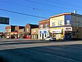
Downtown East Chicago
-
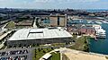
Ameristar Casino
-

Flag of East Chicago
-
Seal of East Chicago
-
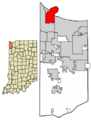
Location of East Chicago in Lake County, Indiana.
