
East Ellijay, Georgia facts for kids
Quick facts for kids
East Ellijay, Georgia
|
||
|---|---|---|

East Ellijay city hall
|
||
|
||

Location in Gilmer County and the state of Georgia
|
||
| Country | United States | |
| State | Georgia | |
| County | Gilmer | |
| Area | ||
| • Total | 3.41 sq mi (8.82 km2) | |
| • Land | 3.40 sq mi (8.81 km2) | |
| • Water | 0.00 sq mi (0.01 km2) | |
| Elevation | 1,273 ft (388 m) | |
| Population
(2020)
|
||
| • Total | 650 | |
| • Density | 191.06/sq mi (73.77/km2) | |
| Time zone | UTC-5 (Eastern (EST)) | |
| • Summer (DST) | UTC-4 (EDT) | |
| ZIP codes |
30539-30540
|
|
| Area code(s) | 706/762 | |
| FIPS code | 13-25356 | |
| GNIS feature ID | 0331619 | |
| Website | https://www.eastellijay.org/ | |

East Ellijay is a city located in Gilmer County, Georgia, in the United States. In 2020, about 650 people lived there.
This city has an important past. It was once the site of Fort Hetzel. This fort was built in 1838. It was used to house the Cherokee people before they were moved from their homes. This difficult journey is known as the "Trail of Tears".
Contents
Geography of East Ellijay
East Ellijay is located in the northern part of Georgia. It shares its northern and western borders with the city of Ellijay.
Land Area and Roads
According to official records, East Ellijay covers an area of about 8.8 square kilometers (3.4 square miles). Almost all of this area is land.
Major roads run through the city. Georgia State Route 5 and Georgia State Route 515 are four-lane highways. They help drivers bypass the main part of Ellijay. These routes go through East Ellijay from north to south. U.S. Route 76 also joins these routes in the northern part of the city.
Nearby Cities and Natural Features
East Ellijay is connected to several other towns. Blue Ridge is about 24 kilometers (15 miles) to the northeast. Jasper is about 31 kilometers (19 miles) to the south. Chatsworth is about 40 kilometers (25 miles) to the west. You can also take Georgia State Route 52 southeast for about 61 kilometers (38 miles) to reach Dahlonega.
The city is also close to nature. It sits on the southern edge of the Chattahoochee National Forest. The Cartecay River flows through East Ellijay. This river is a branch of the Coosawattee River.
Population Changes Over Time
| Historical population | |||
|---|---|---|---|
| Census | Pop. | %± | |
| 1910 | 291 | — | |
| 1920 | 285 | −2.1% | |
| 1930 | 298 | 4.6% | |
| 1940 | 460 | 54.4% | |
| 1950 | 549 | 19.3% | |
| 1960 | 501 | −8.7% | |
| 1970 | 488 | −2.6% | |
| 1980 | 469 | −3.9% | |
| 1990 | 303 | −35.4% | |
| 2000 | 707 | 133.3% | |
| 2010 | 546 | −22.8% | |
| 2020 | 650 | 19.0% | |
| 2023 (est.) | 1,394 | 155.3% | |
| U.S. Decennial Census | |||
The number of people living in East Ellijay has changed over the years. In 1910, there were 291 residents. The population grew to 707 people by 2000. However, it decreased to 546 by 2010. By 2020, the population had risen again to 650 people.
Who Lives in East Ellijay?
In 2000, there were 707 people living in East Ellijay. People from different backgrounds make up the community. Most residents were White. There were also groups of Native American, Pacific Islander, and people from other races. Some residents identified with two or more races. A significant portion of the population was of Hispanic or Latino background.
Families and individuals live in the city. Many households included children under 18. There were also married couples and single-parent families. Some people lived alone, including those aged 65 or older.
Age Groups in the City
The population of East Ellijay includes people of all ages. In 2000, about a quarter of the residents were under 18 years old. A good number were young adults between 18 and 24. The largest group was adults aged 25 to 44. There were also many residents aged 45 to 64, and those 65 or older. The average age in the city was 30 years old.
Images for kids
-
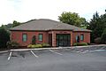
East Ellijay city hall
-
Seal of East Ellijay, Georgia
-
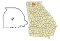
Location in Gilmer County and the state of Georgia
See also
 In Spanish: East Ellijay para niños
