East Thurlow Island facts for kids

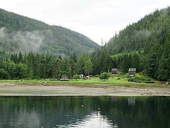
Shoal Bay cabins on East Thurlow Island
|
|

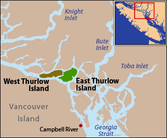
East and West Thurlow Islands are located on Johnstone Strait just north of Discovery Passage.
|
|
| Geography | |
|---|---|
| Coordinates | 50°24′25″N 125°25′44″W / 50.407°N 125.429°W |
| Archipelago | Discovery Islands |
| Administration | |
| Province | British Columbia |
| Regional district | Strathcona |
East Thurlow Island is a beautiful island located in British Columbia, Canada. It's part of a group of islands called the Discovery Islands. These islands are found between a larger island called Vancouver Island and the mainland of Canada. The waters around these islands connect important waterways like the Strait of Georgia, Johnstone Strait, and Queen Charlotte Strait.
East Thurlow Island is situated north of Vancouver Island and south of the mainland. It is also northwest of Sonora Island and east of West Thurlow Island. The island is part of the Strathcona Regional District, which helps manage the area.
Where is East Thurlow Island Located?
East Thurlow Island is surrounded by several channels. The Cordero Channel separates it from the mainland. The Johnstone Strait lies between East Thurlow Island and Vancouver Island. The Nodales Channel separates it from Sonora Island.
Interestingly, East and West Thurlow Islands are very close. They are separated by a narrow passage called Mayne Passage. Just south of East Thurlow Island, the Johnstone Strait meets Discovery Passage. This area is an important spot for boats and ships.
How Did East Thurlow Island Get Its Name?
The island received its current name in 1792. It was named after Edward Thurlow, 1st Baron Thurlow. He was a very important person in England at the time, serving as the Lord Chancellor.
Later, explorers realized that what they thought was one island was actually two! A narrow passage divided them. This passage was first called Blind Channel. It was thought that Captain Vancouver, who explored the area, might have missed it. Many sailors have also missed this turn-off over the years. The channel was later renamed Mayne Passage. However, a small community that grew on the east side of West Thurlow Island kept the name Blind Channel.
A Look Back at Island Life
Life on the islands changed a lot over time. By 1910, a sawmill called Thurlow Island Lumber Company was built at Blind Channel. Many people worked there, including lumbermen, woodsmen, and a blacksmith. You can still see old tree stumps with notches today. These notches show where workers used bucksaws to cut down trees. Wide horse shoes found in the area also show how horses helped move the logs to the mill.
By 1918, the community at Blind Channel had grown to 120 people. Steamships regularly stopped there, bringing supplies and passengers. For many years, the area was very busy. Blind Channel had a cannery, which processed fish, and a shingle mill for making roof tiles. There were even two large dance halls! People came to the area looking for new chances and a way to live independently. The population was at its highest in the 1940s.
 | Kyle Baker |
 | Joseph Yoakum |
 | Laura Wheeler Waring |
 | Henry Ossawa Tanner |

