West Thurlow Island facts for kids

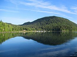
West Thurlow as viewed from Blind Channel
|
|

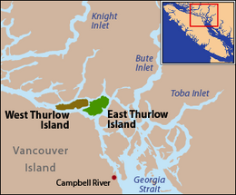
East and West Thurlow islands are located along Johnstone Strait
|
|
| Geography | |
|---|---|
| Coordinates | 50°24′18″N 125°36′58″W / 50.405°N 125.616°W |
| Archipelago | Discovery Islands |
| Administration | |
| Province | British Columbia |
| Regional district | Strathcona |
West Thurlow Island is a beautiful island in British Columbia, Canada. It is part of the Discovery Islands. These islands are a group of islands located between Vancouver Island and the mainland of British Columbia. The waters around them connect the Strait of Georgia with Johnstone Strait and Queen Charlotte Strait.
West Thurlow Island is on the traditional lands of the Kwakwaka'wakw First Nations people. They have lived in this area for a very long time.
Contents
What is the History Behind the Name of West Thurlow Island?
The island was named after Edward Thurlow, 1st Baron Thurlow. He was a very important judge in England called the Lord Chancellor. Captain George Vancouver gave the island its name in July 1792. This happened during his journey through the Johnstone Strait.
Where is West Thurlow Island Located?
West Thurlow Island is found north of Vancouver Island. It is south of the mainland of British Columbia. To its southeast is Hardwicke Island. To its west is East Thurlow Island. A narrow waterway called Blind Channel separates West Thurlow from East Thurlow Island. The island is part of the Strathcona Regional District.
What Waterways Surround West Thurlow Island?
Just north of West Thurlow Island, a long, narrow arm of the sea called Loughborough Inlet stretches into the mainland. The strait that separates West Thurlow Island from the mainland has two names. To the east of Loughborough Inlet, it is called Cordero Channel. To the west, it is known as Chancellor Channel. Another strait, Beauty Cat Strait, separates West Thurlow Island from Vancouver Island.
What Kind of Places Can You Find on the Island?
There are a few private properties on the eastern side of the island. Many of these are near Blind Channel Resort. This resort has a marina where boats can dock. It also has a place to refuel boats, a general store, and a post office. During certain times of the year, it also offers a restaurant and places to stay.
What is the History of Forestry on West Thurlow Island?
Logging, which is cutting down trees for wood, started on the island a long time ago. The Thurlow Island Lumber Company built a sawmill in 1918. This sawmill was located where Blind Channel Resort is today.
How Did Logging Affect the Island's Population?
Small communities grew around the sawmill. By the 1940s, several hundred people lived there. However, there are no permanent logging camps on the island anymore.
Who Manages the Forests on West Thurlow Island Today?
Today, parts of West Thurlow Island are managed under two special agreements called tree farm licenses. These are licenses 45 and 47. International Forest Products Ltd. (Interfor) holds one, and Timberwest holds the other.
Workers can access these areas using two dry-land timber sorts. These are places where logs are collected and sorted. They are located at Knox Bay and Butterfly Bay, both on the southern shore of the island.
What Types of Trees Grow on West Thurlow Island?
West Thurlow Island is in a special forest area known as the Coastal Western Hemlock biogeoclimatic zone. The forests here are mostly made up of three types of trees:
- Western hemlock
- Douglas fir
- Western red cedar
 | Selma Burke |
 | Pauline Powell Burns |
 | Frederick J. Brown |
 | Robert Blackburn |

