
East Turkestan facts for kids

East Turkistan, also known as Uyghuristan or Uyghurstan, is a name for the eastern part of the larger Turkestan region in Central Asia. In the Uyghur language, it is called Sherqiy Türkistan or Uyghuriye. This area covers about 1,664,900 square kilometers and had a population of around 21.8 million people in 2010. It is a land of diverse landscapes, from high mountains to vast deserts.
Contents
What is East Turkistan?
East Turkistan refers to a specific region in Central Asia. It is often linked to the Xinjiang Uyghur Autonomous Region in China. The name "East Turkistan" is mainly used by Uyghur people living outside the region, especially those who want to see it as an independent country.
Geography and Landscape
East Turkistan has a very interesting geography. It includes the Tarim Basin, which is a large area surrounded by mountains.
- To the north, the Tian Shan mountain range separates it from another region called Dzungaria.
- The Kunlun Mountains are to the south.
- The Taklamakan Desert, one of the largest sandy deserts in the world, is located in the center of the Tarim Basin.
Despite the desert, there are oases (fertile spots with water) where people live and farm.
People and Culture
The main group of people living in this region are the Uyghur people. They are a Turkic ethnic group with a rich history and culture.
- Uyghurs have their own language, which is related to other Turkic languages.
- Their culture includes unique music, dances, and traditional crafts.
- Most Uyghurs practice Islam.
Historical Roots of the Name
The term "East Turkistan" has been used for a long time. It helps to describe the eastern part of a much larger historical region called Turkestan. This bigger region stretches across Central Asia and was historically home to many Turkic-speaking peoples.
A Look at History
The history of East Turkistan is long and complex, with many different groups living there over thousands of years.
Ancient Times and the Silk Road
For a very long time, the Tarim Basin was an important part of the Silk Road. This was a network of ancient trade routes connecting the East and West.
- Many city-states grew up in the oases along the Silk Road.
- These cities were important stops for traders, travelers, and cultural exchange.
- Different empires and kingdoms controlled parts of the region throughout history.
Modern History and Political Changes
In more recent times, the region has seen many changes.
- In the 1800s, there were conflicts and campaigns involving Chinese forces and local leaders.
- Maps from the late 1800s and early 1900s often showed this area as "Chinese Turkistan" or "Sin-Kiang."
- There were also times when local people tried to form their own independent states, like the East Turkestan Republic in the 1930s and 1940s. They even had their own money, like the $1000 East Turkistan Dollar Note from 1945.
The Name Today
Today, the name "East Turkistan" is mostly used by Uyghur groups outside of China. They use it to talk about their homeland and their desire for self-determination. Inside China, the region is officially known as the Xinjiang Uyghur Autonomous Region.
Images for kids
-
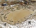
Cities of the Tarim Basin region, 1 BC
-
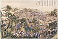
Qing-era painting depicting a Chinese campaign against Jahangir Khoja's forces in Xinjiang, 1828
-
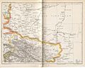
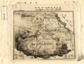
Map including part of Chinese Turkistan (1893)
-
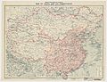
Map including Sin-Kiang and other territories of China (NGS, 1912)
-
Political map of East Turkestan Republic in 1947
-
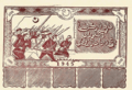
$1000 East Turkistan Dollar Note, 1945
-

The term "East Turkestan" is primarily used by, and is associated with, Uyghur separatists (diasporic protest in Washington, D.C. shown)
.jpg)


See also
 In Spanish: Turquestán Oriental para niños
