
Dzungaria facts for kids
Quick facts for kids Dzungaria |
|||||||||||
|---|---|---|---|---|---|---|---|---|---|---|---|

Dzungaria (Junggar Basin) Southern Xinjiang (Tarim Basin)
|
|||||||||||
| Chinese name | |||||||||||
| Simplified Chinese | 准噶尔 | ||||||||||
| Traditional Chinese | 準噶爾 | ||||||||||
|
|||||||||||
| Beijiang | |||||||||||
| Chinese | 北疆 | ||||||||||
| Literal meaning | Northern Xinjiang | ||||||||||
|
|||||||||||
| Mongolian name | |||||||||||
| Mongolian Cyrillic | Зүүнгар нутаг | ||||||||||
| Uyghur name | |||||||||||
| Uyghur | جوڭغار | ||||||||||
|
|||||||||||
Dzungaria (pronounced like "zung-GAIR-ee-uh") is a special area in Northwest China. It's also known as Northern Xinjiang or Beijiang. This region is the northern part of Xinjiang, a large province in China.
Dzungaria is bordered by the Altai Mountains in the north and the Tian Shan mountains in the south. It covers a huge area of about 777,000 square kilometers (which is roughly the size of Texas!). To its west is Kazakhstan, and to its east is Mongolia.
Even though Dzungaria has its own unique history and people, it was joined with another area called the Tarim Basin (or Southern Xinjiang) by the Qing dynasty a long time ago. Together, they formed the province of Xinjiang. Today, Dzungaria is a very important part of Xinjiang. It's a hub for big industries and creates most of the region's wealth. The capital city of Xinjiang, Ürümqi, which means 'beautiful pasture' in the Oirat language, is located here. Because of its importance, many people move to Dzungaria's cities from other parts of Xinjiang and China to find work. It's also well-connected to the rest of China by trains and trade routes.
Contents
Understanding Dzungaria's Past
Xinjiang has always been seen as two different areas: Dzungaria in the north (above the Tian Shan mountains) and the Tarim Basin in the south (below the mountains).
When the Qing dynasty took control of Xinjiang in 1759, Dzungaria was mostly home to the Dzungars. These were nomadic people who lived on the open grasslands and followed Tibetan Buddhism. The Tarim Basin, on the other hand, had people who lived in oasis towns. They were farmers, mostly Turkic and Muslim, and are now known as the Uyghurs.
The Qing government knew these two groups were different. At first, they ruled them separately. But after taking full control of the Tarim Basin in 1760, the Qing government started calling both areas "Xinjiang," which means "new frontier."
In 1884, the Qing government officially made Dzungaria and the Tarim Basin one province called Xinjiang Province. Some officials thought it was better to keep them separate, but the government decided to unite them. The idea of "Xinjiang" as one place was created by the Qing government. By the time the Qing dynasty ended in 1912, the local people of Xinjiang still didn't feel like they had one shared identity. However, the Qing government's policies, like keeping Xinjiang somewhat separate from the rest of Central Asia and bringing in new settlers from China, slowly helped create a unique culture in Xinjiang.
A Look at Dzungaria's History
Dzungaria has a very long and interesting history! Over many centuries, different empires and groups have ruled or influenced this region.
Here are some of the groups that have been in charge of Dzungaria or parts of it:
- The Xiongnu Empire
- The Han dynasty
- The Tang dynasty
- The Mongol Empire
- The Dzungar Khanate
- The Qing dynasty
- The Republic of China
- And since 1950, it has been controlled by the People's Republic of China.
What Does "Dzungaria" Mean?
The name Dzungaria comes from the Dzungar Khanate, a powerful kingdom that existed in Central Asia in the 1600s and 1700s.
The word "Dzungar" comes from the Mongolian words Zűn Gar or Jüün Gar. Zűn (or Jüün) means 'left', and Gar means 'hand'. This name came about because the Western Mongols (Oirats) were seen as being on the "left-hand side" when the huge Mongol Empire started to split into Eastern and Western parts. After this split, the western Mongolian nation was called Zuun Gar.
Early History of Dzungaria

Some of the first people to live in this area spoke Indo-European languages. For example, the Tocharians lived here long ago, and the Jushi Kingdom was present around 1000 BC.
One of the earliest mentions of Dzungaria comes from the Han dynasty. They sent an explorer to the lands to the west. This explorer used the northern part of the Silk Road, a famous ancient trade route. This path was about 2,600 kilometers long and connected the old Chinese capital of Xi'an to places like Kashgar.
Later, in the 500s AD, a leader named Istämi of the Göktürks took control of Dzungaria after his father passed away.
The Dzungar power was strongest in the late 1600s. Their leader, Galdan Boshugtu Khan, often got involved in the affairs of the Kazakhs to the west. However, the Dzungar power was completely defeated by the Qing Empire around 1757–1759. This event was a big part of the history of Mongolia and the movement of Mongolian groups westward. At its largest, the Dzungar territory included places like Kashgar, Yarkand, and Khotan, covering most of the Tian Shan region and a large part of Central Asia.
After 1761, most of this land became part of the Qing dynasty (which became Xinjiang and north-western Mongolia). Some parts also went to Russian Turkestan.
Dzungaria and the Silk Road
If you were traveling west from China a long time ago, you had two main choices: go north of the Tian Shan mountains through Dzungaria, or go south through the Tarim Basin. Usually, trade caravans took the southern route, while large groups of people (migrations) used the northern route.
Why? The Tarim Basin route led to the Fergana Valley and then to Iran. The problem was the very high mountains between the Tarim and Ferghana. Also, the Taklamakan Desert in the Tarim Basin is too dry for much grass, so nomads couldn't easily live there unless they were raiding trade caravans. The people living there were mostly farmers and merchants in oasis towns, who wanted trade to be safe and smooth.
Dzungaria, however, had more grass and fewer towns. It also had no major mountain barriers to the west. This made it easier for large groups of people to move through. Today, most trade goes north of the mountains, through places like the Dzungarian Gate and Khorgas. This avoids the difficult mountains west of the Tarim Basin and connects to more developed areas like Russia.
Dzungaria in Modern Times
After the Dzungars were defeated by the Qing, the Qing government started to bring in new people, including Han Chinese and Hui people, to live in the area.
Today, in the 21st century, the people living in Dzungaria include Kazakhs, Kyrgyz, Mongols, Uyghurs, and Han Chinese. Since 1953, many skilled workers, mostly Han Chinese, have moved to northern Xinjiang. They came to work on projects like water conservation and in industries, especially the Karamay oil fields. Many people from the poorer Uyghur areas of southern Xinjiang have also moved to the capital city of Ürümqi in Dzungaria to find jobs.
The name "Dzungaria" isn't used as much on maps today for the whole region. But a mountain range stretching northeast along the border of Zhetysu is still called the Dzungarian Alatau. It also gave its name to the cute Djungarian hamsters!
Exploring Dzungaria's Geography


In Dzungaria, farmers grow crops like wheat, barley, oats, and sugar beets. People also raise cattle, sheep, and horses. The fields get water from melted snow that comes from the tall, snow-capped mountains. Dzungaria is also rich in natural resources. It has deposits of coal, gold, and iron, as well as large oil fields.
The Dzungarian Basin
The main part of Dzungaria is a bowl-shaped area called the Dzungarian Basin, also known as Junggar Basin. In its center is the Gurbantünggüt Desert. This basin is surrounded by mountains: the Tarbagatai Mountains to the northwest, the Altai Mountains to the northeast, and the Tian Shan mountains to the south.
The basin has three corners that are somewhat open. The northern corner is the valley of the upper Irtysh River. The western corner is the Dzungarian Gate, which has been an important path between Dzungaria and the Kazakh Steppe for a long time. Today, a highway and a railway (opened in 1990) run through it, connecting China with Kazakhstan. The eastern corner leads to Gansu and the rest of China. In the south, an easy path connects Ürümqi to the Turfan Depression. To the southwest, the tall Borohoro Mountains (a branch of the Tian Shan) separate the basin from the upper Ili River.
The Dzungarian Basin is similar to the larger Tarim Basin, which is on the southern side of the Tian Shan Range. However, a gap in the mountains to the north allows moist air to enter the Dzungarian Basin. This makes it a semi-desert instead of a true desert like most of the Tarim Basin. This moisture allows a thin layer of plants to grow, which supports wild animals like camels and jerboas.
Geologists have found that the Dzungarian Basin has very old rocks and large amounts of oil reserves. The Gurbantunggut Desert, which is China's second largest desert, is right in the middle of the basin.
The Dzungarian Basin doesn't have one single river system that drains to the ocean. The northernmost part drains into the Irtysh River, which eventually flows to the Arctic Ocean. But most of the region has rivers that flow into lakes that don't connect to the ocean (these are called endorheic basins). For example, the Ulungur River flows into Lake Ulungur. The southwestern part of the basin drains into Aibi Lake. In the west-central area, streams flow into a group of lakes, including Lake Manas and Lake Ailik. Long ago, there was a much larger lake called the "Old Manas Lake" in this area. It was fed by the Irtysh and Ulungur rivers, which flowed into it at that time.
The climate in the Dzungarian Basin is influenced by the cold weather from nearby Siberia. This makes temperatures colder, sometimes as low as -4°F (-20°C), and brings more rain and snow (from 3 to 10 inches) compared to the warmer, drier basins to the south. Water from the surrounding mountains flows into the basin, feeding several lakes. This area used to have rich habitats with meadows, marshlands, and rivers. However, much of the land is now used for farming.
The basin is mostly steppe (grassland) and semi-desert, surrounded by high mountains: the Tian Shan in the south and the Altai in the north. Geologically, it's an extension of an ancient landmass called the Paleozoic Kazakhstan Block.
The main cities in Dzungaria are Ürümqi, Yining, and Karamai. There are also smaller oasis towns scattered around the edges of the mountains.
Dzungaria's Amazing Wildlife
Dzungaria is home to a special semi-desert ecoregion called the Dzungarian Basin semi-desert. The plants here are mostly low shrubs like Anabasis brevifolia. Taller shrubs like saxaul bush (Haloxylon ammodendron) and Ephedra przewalskii can be found near the edges of the basin. Rivers flowing down from the Tian Shan and Altai mountains support stands of poplar trees (Populus diversifolia) along with other plants like Nitraria roborovsky, N. sibirica, Neotrinia splendens, tamarisk (Tamarix sibirimosissima), and willow (Salix ledebouriana).
The northeastern part of the Dzungarian Basin semi-desert is part of the Great Gobi National Park. This park is home to herds of Onagers (wild donkeys), goitered gazelles, and Wild Bactrian camels.
The basin was also one of the last places where Przewalski's horse (also known as the Dzungarian horse) lived in the wild. This horse was once extinct in the wild, but it has since been brought back to areas in Mongolia and China.
Ancient Animals of Dzungaria
Scientists have found fossils of many ancient animals in the rocky areas of the Dzungar Basin. Some of these animals are even named after Dzungaria!
- Dsungaripterus weii (a flying reptile called a pterosaur)
- Junggarsuchus sloani (a type of ancient crocodile-like creature)
A very exciting discovery was made in February 2006. A team of scientists found the oldest tyrannosaur fossil ever in the Dzungarian Basin. This new species was named Guanlong. It lived 160 million years ago, which is more than 90 million years before the famous Tyrannosaurus rex walked the Earth!
Images for kids
-
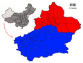
Dzungaria (Junggar Basin) Southern Xinjiang (Tarim Basin)
-
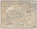
A map of the Dzungar Khanate, by a Swedish officer in captivity there in 1716–1733, which include the region known today as Zhetysu
-
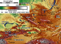
Physical map showing the separation of Dzungaria and the Tarim Basin (Taklamakan) by the Tian Shan Mountains
-
Heaven Lake of Tian Shan
-
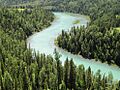
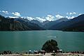
Kanas Lake
-
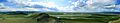
Bayanbulak Grassland
See Also
- Shishugou Formation dinosaur traps
- Junggar Basin
- Southern Xinjiang
- Chinese Turkestan
