Edmore, Michigan facts for kids
Quick facts for kids
Edmore, Michigan
|
|
|---|---|
|
Village
|
|

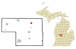
Location of Edmore in Montcalm County and the state of Michigan
|
|
| Country | United States |
| State | Michigan |
| County | Montcalm |
| Township | Home |
| Area | |
| • Total | 1.52 sq mi (3.94 km2) |
| • Land | 1.52 sq mi (3.94 km2) |
| • Water | 0.00 sq mi (0.00 km2) |
| Elevation | 968 ft (295 m) |
| Population
(2020)
|
|
| • Total | 1,210 |
| • Density | 795.01/sq mi (306.94/km2) |
| Time zone | UTC-5 (Eastern (EST)) |
| • Summer (DST) | UTC-4 (EDT) |
| ZIP code |
48829
|
| Area code(s) | 989 |
| FIPS code | 26-25000 |
| GNIS feature ID | 2398789 |
Edmore is a small village located in Montcalm County, in the state of Michigan, USA. In 2020, about 1,210 people lived there.
Contents
History of Edmore
Edmore was started in 1878 by a man named Edwin B. Moore. He was a real estate agent and planned out the village, giving it a name that was a shorter version of his own.
A post office opened in Edmore on July 22, 1878. Abraham West was the first postmaster. The village also had a train station called "Edmore Junction" on the Detroit, Lansing and Northern Railroad line. Edmore officially became a village in 1879, and Edwin B. Moore was its first leader.
The Edmore post office, with ZIP code 48829, serves the village and parts of several nearby areas. These include Home Township, Belvidere Township, Douglass Township, Day Township, Ferris Township, and Rolland Township.
The Edmore Meteorite
In 2018, a special rock called the Edmore meteorite was found near the village. It was discovered on a farm and had reportedly fallen to Earth way back in the 1930s. For many years, it was simply used as a doorstop on another farm before people realized it was a valuable meteorite!
Geography of Edmore
Edmore is located in the northeastern part of Montcalm County. It is about 10 miles (16 km) north-northeast of Stanton, which is the main town of the county. The village covers a total area of about 1.52 square miles (3.94 square kilometers), and all of it is land.
Main Roads in Edmore
- M-46 is an important highway that runs through Edmore. This road goes almost all the way across the lower part of Michigan. If you head east on M-46, you'll reach St. Louis in about 21 miles (34 km). If you go west, you'll get to Lakeview in about 12 miles (19 km).
Population of Edmore
| Historical population | |||
|---|---|---|---|
| Census | Pop. | %± | |
| 1880 | 704 | — | |
| 1890 | 735 | 4.4% | |
| 1900 | 642 | −12.7% | |
| 1910 | 752 | 17.1% | |
| 1920 | 772 | 2.7% | |
| 1930 | 897 | 16.2% | |
| 1940 | 825 | −8.0% | |
| 1950 | 971 | 17.7% | |
| 1960 | 1,234 | 27.1% | |
| 1970 | 1,149 | −6.9% | |
| 1980 | 1,176 | 2.3% | |
| 1990 | 1,126 | −4.3% | |
| 2000 | 1,244 | 10.5% | |
| 2010 | 1,201 | −3.5% | |
| 2020 | 1,210 | 0.7% | |
| U.S. Decennial Census | |||
The population of Edmore has changed over the years, as shown in the table above. In 2010, there were 1,201 people living in the village. The population density was about 795 people per square mile (307 people per square kilometer).
Most of the people living in Edmore are White. A small percentage of residents are African American, Native American, or Asian. Some people also identify as Hispanic or Latino.
In 2010, about 24.6% of the people in Edmore were under 18 years old. About 16.6% were 65 years old or older. The average age in the village was 38.8 years. There were slightly more females than males living in Edmore.
See also
 In Spanish: Edmore (Míchigan) para niños
 | Tommie Smith |
 | Simone Manuel |
 | Shani Davis |
 | Simone Biles |
 | Alice Coachman |

