Eklutna Glacier facts for kids
Quick facts for kids Eklutna Glacier |
|
|---|---|

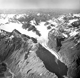
Eklutna Glacier, valley glacier, August 25, 1964
|
|
| Coordinates | 61°15′51″N 148°59′18″W / 61.264137°N 148.988343°W |
| Area | 11.5 square miles (30 km2) |
| Length | 6 miles (9.7 km) |
The Eklutna Glacier is a large glacier found in Chugach State Park in Alaska. It is part of the Chugach Mountains, close to the city of Anchorage, Alaska. This glacier is super important because its melting ice helps fill Eklutna Lake. This lake provides most of the drinking water for Anchorage. It also helps make electricity through the Eklutna Hydroelectric Project. Sadly, the Eklutna Glacier is getting smaller because of climate change. This will affect the water supply in the future. The local Dena'ina people call this glacier Idlu Bena Li'a.
Contents
About the Glacier
Eklutna Glacier is a type of valley glacier. It is about 10 kilometers (6 miles) long and covers 29 square kilometers (11.5 square miles). This glacier has been around since a very long time ago, during the Pleistocene Ice Age.
The glacier has two main parts, or "branches." These branches join together about 2.7 kilometers (1.7 miles) before the end of the glacier. The "Main Branch" is wide and not very steep. The "West Branch" is smaller and steeper.
The glacier's height changes a lot. At its lowest point, where it ends, it's about 580 meters (1,900 feet) above sea level. Its highest point is around 2,100 meters (6,900 feet). The mountains around the glacier are very tall, with some peaks over 2,500 meters (8,200 feet) high. Another glacier, Whiteout Glacier, is next to Eklutna Glacier.
Meltwater from the glacier forms the West Fork Eklutna River. This river flows north into Eklutna Lake. The lake itself was formed naturally when a pile of rocks and dirt, left by the glacier, blocked the valley.
Why the Glacier is Shrinking
Like many glaciers in Alaska, Eklutna Glacier is getting smaller. This is happening because the climate is getting warmer. Eklutna Glacier is in a coastal area where the weather is often mild. Glaciers in these areas, especially those at lower heights, are melting faster than others.
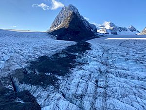
Scientists have been watching Eklutna Glacier closely. Between 1975 and 2015, the end of the glacier moved back by 1.6 kilometers (1 mile). This means it got shorter. But most of the ice loss is from the glacier getting thinner. From 2010 to 2015, the glacier's surface dropped by about 0.85 meters (2.8 feet) each year. This is faster than the period from 1957 to 2010, when it dropped by 0.6 meters (2 feet) per year.
The glacier has a "negative mass balance." This means more ice is melting than new snow is falling and turning into ice. As the climate keeps warming, the glacier will continue to shrink. Eventually, it might not release much meltwater anymore. This would cause big problems for Eklutna Lake, which relies on the glacier's water.
Glacier History
Eklutna Glacier and its neighbor, Whiteout Glacier, were once used for military training. From the 1950s to the mid-1970s, soldiers from Fort Richardson practiced special skills here. They learned how to ski across snow, climb down ropes into deep cracks in the ice called crevasses, and travel safely on glaciers. Training in Alaska's tough winters helped prepare them for cold weather battles in other parts of the world.
Studying the Glacier
People have been watching how Eklutna Glacier changes since the early 1900s. Over time, the research on the glacier has become much more detailed.
From 1985 to 1988, the USGS worked with Anchorage to study the glacier. They looked at how much water and sediment (like dirt and rocks) the glacier added to Eklutna Lake. Since the late 1980s, different groups have done field work on the glacier. They measure how much snow builds up (accumulation) and how much ice melts away (ablation).
This research involves digging snow pits and putting stakes into the ice. They also set up weather stations and use lasers to measure the glacier's height. In 2017, new research on the glacier's mass and height was published. This study used both remote sensing (like satellites) and field measurements. You can find this research in the Journal of Glaciology.
Fun Activities
The Eklutna Traverse is a popular route for mountaineers. It connects Eklutna Glacier, Whiteout Glacier, and Eagle Glacier. However, as Eklutna Glacier gets smaller and thinner, walking on it has become more dangerous. It's now a technical route, meaning you need special skills and experience to cross it safely.
The Mountaineering Club of Alaska takes care of three old huts along the Eklutna Traverse. These huts can be used by people traveling the route. One of them is Pichler's Perch, built in 1964. It's located on the northeast side of Eklutna Glacier, near its end.
 | Sharif Bey |
 | Hale Woodruff |
 | Richmond Barthé |
 | Purvis Young |


