Elim, Alaska facts for kids
Quick facts for kids
Elim
|
|
|---|---|

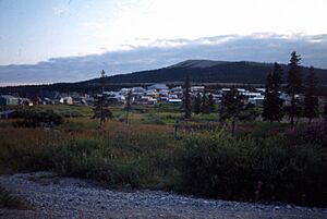
View of Elim in August 1993
|
|
| Country | United States |
| State | Alaska |
| Census Area | Nome |
| Incorporated | October 17, 1970 |
| Area | |
| • Total | 2.66 sq mi (6.89 km2) |
| • Land | 2.66 sq mi (6.89 km2) |
| • Water | 0.00 sq mi (0.00 km2) |
| Elevation | 36 ft (11 m) |
| Population
(2020)
|
|
| • Total | 366 |
| • Density | 137.65/sq mi (53.14/km2) |
| Time zone | UTC-9 (Alaska (AKST)) |
| • Summer (DST) | UTC-8 (AKDT) |
| ZIP code |
99739
|
| Area code | 907 |
| FIPS code | 02-22250 |
| GNIS feature ID | 1401788 |
Elim is a small city in Nome Census Area, Alaska, United States. Its native names are Central Yupik: Neviarcaurluq and Inupiaq: Nivviaqhchauġluq. In 2020, about 366 people lived there.
Contents
Geography and Climate in Elim
Elim is located in Alaska at coordinates 64.617734 degrees North and -162.256705 degrees West. The city covers about 2.4 square miles (6.2 square kilometers) of land. There is no water area within the city limits.
What is Elim's Climate Like?
Elim has a subarctic climate. This means winters are very cold and long. Summers are usually warm but short.
| Climate data for Moses Point Airport, Alaska | |||||||||||||
|---|---|---|---|---|---|---|---|---|---|---|---|---|---|
| Month | Jan | Feb | Mar | Apr | May | Jun | Jul | Aug | Sep | Oct | Nov | Dec | Year |
| Record high °F (°C) | 42 (6) |
45 (7) |
44 (7) |
49 (9) |
75 (24) |
87 (31) |
84 (29) |
80 (27) |
69 (21) |
59 (15) |
39 (4) |
36 (2) |
87 (31) |
| Mean maximum °F (°C) | 31.5 (−0.3) |
29.4 (−1.4) |
33.0 (0.6) |
41.0 (5.0) |
62.4 (16.9) |
73.8 (23.2) |
75.8 (24.3) |
69.5 (20.8) |
59.1 (15.1) |
45.6 (7.6) |
33.9 (1.1) |
30.1 (−1.1) |
79.3 (26.3) |
| Mean daily maximum °F (°C) | 8.8 (−12.9) |
8.0 (−13.3) |
14.7 (−9.6) |
26.2 (−3.2) |
43.5 (6.4) |
57.6 (14.2) |
61.2 (16.2) |
57.9 (14.4) |
49.0 (9.4) |
31.7 (−0.2) |
19.2 (−7.1) |
6.0 (−14.4) |
32.0 (0.0) |
| Daily mean °F (°C) | 1.7 (−16.8) |
0.8 (−17.3) |
6.1 (−14.4) |
18.1 (−7.7) |
36.3 (2.4) |
50.0 (10.0) |
54.1 (12.3) |
51.9 (11.1) |
42.9 (6.1) |
26.1 (−3.3) |
13.1 (−10.5) |
−0.6 (−18.1) |
25.0 (−3.9) |
| Mean daily minimum °F (°C) | −5.4 (−20.8) |
−6.5 (−21.4) |
−2.4 (−19.1) |
10.1 (−12.2) |
29.1 (−1.6) |
42.4 (5.8) |
47.1 (8.4) |
46.0 (7.8) |
36.8 (2.7) |
20.5 (−6.4) |
7.0 (−13.9) |
−7.2 (−21.8) |
18.1 (−7.7) |
| Mean minimum °F (°C) | −36.0 (−37.8) |
−34.9 (−37.2) |
−29.2 (−34.0) |
−18.6 (−28.1) |
11.1 (−11.6) |
33.1 (0.6) |
37.6 (3.1) |
33.6 (0.9) |
22.9 (−5.1) |
1.6 (−16.9) |
−18.5 (−28.1) |
−34.0 (−36.7) |
−42.5 (−41.4) |
| Record low °F (°C) | −48 (−44) |
−49 (−45) |
−43 (−42) |
−39 (−39) |
−7 (−22) |
26 (−3) |
32 (0) |
28 (−2) |
16 (−9) |
−14 (−26) |
−42 (−41) |
−54 (−48) |
−54 (−48) |
| Average precipitation inches (mm) | 1.15 (29) |
0.92 (23) |
1.07 (27) |
0.91 (23) |
0.59 (15) |
0.73 (19) |
1.85 (47) |
4.20 (107) |
3.07 (78) |
1.21 (31) |
1.51 (38) |
1.04 (26) |
18.26 (464) |
| Average snowfall inches (cm) | 10.1 (26) |
9.2 (23) |
10.3 (26) |
7.4 (19) |
0.8 (2.0) |
0.0 (0.0) |
0.0 (0.0) |
0.0 (0.0) |
0.3 (0.76) |
4.8 (12) |
13.1 (33) |
9.8 (25) |
65.8 (167) |
| Source: WRCC | |||||||||||||
Nature and Wildlife in Elim
The area around Elim is home to many different plants and animals. One special plant found here is the Black Spruce tree. This is the farthest west you can find this type of tree.
People and Population in Elim
| Historical population | |||
|---|---|---|---|
| Census | Pop. | %± | |
| 1920 | 162 | — | |
| 1930 | 97 | −40.1% | |
| 1940 | 100 | 3.1% | |
| 1950 | 154 | 54.0% | |
| 1960 | 145 | −5.8% | |
| 1970 | 174 | 20.0% | |
| 1980 | 211 | 21.3% | |
| 1990 | 264 | 25.1% | |
| 2000 | 313 | 18.6% | |
| 2010 | 330 | 5.4% | |
| 2020 | 366 | 10.9% | |
| U.S. Decennial Census | |||
Elim first appeared in the U.S. Census in 1920. It officially became a city in 1970.
Who Lives in Elim?
Based on the 2000 census, there were 313 people living in Elim. Most of the people living there were Native American (about 92.65%). A smaller number were White (about 5.11%).
There were 84 households in the city. Many households (60.7%) had children under 18 living with them. The average household had about 3.73 people.
Age Groups in Elim
The population in Elim is quite young. About 41.9% of the people were under 18 years old. The average age was 24 years. For every 100 females, there were about 131.9 males.
Getting Around Elim
Airports in Elim
Elim has two airports. The Elim Airport is owned by the state and has regular passenger flights. The other airport, Moses Point Airport, is privately owned by the Elim Native Corporation.
Education in Elim
Students in Elim attend schools run by the Bering Strait School District. The local school, Aniguiin School, teaches students from Pre-Kindergarten all the way through 12th grade.
See also
 In Spanish: Elim (Alaska) para niños
 | Percy Lavon Julian |
 | Katherine Johnson |
 | George Washington Carver |
 | Annie Easley |


