Ellicott's Stone facts for kids
Quick facts for kids |
|
|
Ellicott Stone
|
|

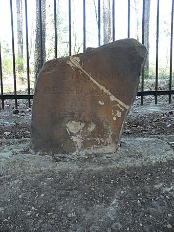
The south side of the stone. It reads: Dominio De S.M. Carlos IV, Lat. 31, 1799.
|
|
| Nearest city | Bucks, Alabama |
|---|---|
| Area | less than one acre |
| Built | 1799 |
| NRHP reference No. | 73000359 |
| Added to NRHP | April 11, 1973 |
The Ellicott Stone, also called Ellicott's Stone, is a special boundary marker in northern Mobile County, Alabama. It was put in place on April 10, 1799. This was done by a team of surveyors from the U.S. and Spain. The team was led by Andrew Ellicott. This important stone was added to the National Register of Historic Places on April 11, 1973.
The Ellicott Stone is the only known stone marker placed by Andrew Ellicott. He was surveying the 31st parallel north latitude. This line was chosen as the border between the Mississippi Territory (part of the United States) and Spanish West Florida. The border stretched along the 31st parallel from the Mississippi River all the way east to the Chattahoochee River. This boundary was agreed upon in the 1795 Pinckney Treaty, also known as the Treaty of San Lorenzo.
The Ellicott Stone is very important for how land is measured in the southern parts of Alabama and Mississippi. It is the starting point for all Public Land surveys in this area. It marks where the St. Stephens meridian and the St. Stephens baseline cross each other. All the land sections, called townships, in this region are numbered starting from this stone.
You can find the marker stone east of U.S. Route 43. It is located in Ellicott Stone Historical Park, about 1 mile (1.6 km) south of Bucks, Alabama. The park was created in 1917. Today, it is close to the James M. Barry Electric Generating Plant, which is west of the Mobile River.
What the Stone Looks Like
The Ellicott Stone is a block of rusty-colored sandstone. It stands about two feet (0.6 meters) tall and is eight inches (203 mm) thick. It is located near the west bank of the Mobile River.
Messages on the Stone
On the northern side of the stone, you can read the words "U.S. Lat. 31, 1799." This means "United States, Latitude 31, 1799."
The southern side of the stone has a message in Spanish. It says "Dominio De S.M. Carlos IV, Lat. 31, 1799." This translates to "Dominion of his majesty King Charles IV, Latitude 31, 1799." These inscriptions show that the stone marked the border for both countries.
 | William M. Jackson |
 | Juan E. Gilbert |
 | Neil deGrasse Tyson |


