
Emery, Ohio facts for kids
Quick facts for kids
Emery, Ohio
|
|
|---|---|

Location of Emery, Ohio
|
|
| Country | United States |
| State | Ohio |
| County | Fulton |
| Township | Dover |
Emery is a ghost town located in Dover Township, Fulton County, Ohio. It is near the modern-day town of Tedrow, Ohio. A ghost town is a place where people once lived and worked, but now it is mostly empty, and often its buildings are gone.
What Happened to Emery?
Emery once had its own post office. This post office first opened on July 11, 1846. A person named Amos Gay was the very first postmaster, which is the person in charge of a post office.
The post office closed for a while on January 23, 1861. But it reopened later that same year, on May 23. This time, William Waid became the new postmaster. The post office stayed open for many years after that. It finally closed for good on August 31, 1903.
A special letter from the time of the American Civil War (around 1861) was sent to the Emery Post Office. This letter is still kept safe today at Bowling Green State University. It is part of the Searls Family Papers, which are old family documents.
Emery was also listed in old books. It appeared in a business directory from 1860 and a Post Office directory from 1870. This shows that it was an active place back then. We even know that Will and Emma Knapp were residents of Emery, Ohio, thanks to old family records.
Emery even showed up on an Ohio railroad map from 1898. However, the mapmaker made a small mistake. They drew Emery in the spot where Spring Hill should have been. Also, a new railroad line on the map was drawn incorrectly. It was supposed to go north from Wauseon towards Oakshade. But on the map, it mistakenly turned east towards a station at Ottokee, which was actually the location of Winameg.
Where Was Emery?
Emery was located only a short distance from a place called Spring Hill. It was about 1.5 miles southwest of Spring Hill. Today, there are no buildings left from the old town of Emery.
According to some old records, Emery was located near County Road H. This road used to be called West Unity-Swanton Road. It was between County Road 17 (which was Hartman-Inlet Road) and County Road 16 (which was Lena-Morenci Road). This means Emery might have been located where the Ohio Turnpike is now, or just north of it.
Gallery
-
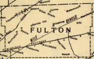
This is a 1890 railroad map. Emery would be located near the "U" in "Fulton," just southwest of "Spring Hill." Notice that Beta, another town that no longer exists in Fulton County, is also shown on this map.
-
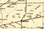
This is a 1898 railroad map. Emery is on this map, but it was mistakenly labeled in the place of Spring Hill. Emery would actually have been located closer to the top of the "L" in "Fulton."


