
Encinal, Texas facts for kids
Quick facts for kids
Encinal, Texas
|
|
|---|---|

Encinal water tower
|
|

Location of Encinal, Texas
|
|
 |
|
| Country | United States |
| State | Texas |
| County | La Salle |
| Area | |
| • Total | 0.43 sq mi (1.12 km2) |
| • Land | 0.43 sq mi (1.12 km2) |
| • Water | 0.00 sq mi (0.00 km2) |
| Elevation | 558 ft (170 m) |
| Population
(2020)
|
|
| • Total | 540 |
| • Density | 1,256/sq mi (482/km2) |
| Time zone | UTC-6 (Central (CST)) |
| • Summer (DST) | UTC-5 (CDT) |
| ZIP code |
78019
|
| Area code(s) | 956 |
| FIPS code | 48-24240 |
| GNIS feature ID | 2410439 |
| Website | https://www.cityofencinal.com/ |
Encinal is a small city in La Salle County, Texas, United States. In 2020, about 540 people lived there. A major road, Interstate 35 Business, goes right through the city. There aren't many businesses in Encinal anymore; most have closed down.
The town's name, Encinal, comes from a Spanish word meaning 'oak grove'. The most people who ever lived here at one time was about 800, back in 1937.
Contents
History of Encinal
The name Encinal comes from a Spanish word for a type of oak tree grove. Long ago, Encinal was planned to be the main town (the county seat) for a new area called Encinal County. This county was created in 1856 from part of Webb County.
But this new county never really got started. It was officially ended in 1899. The land that was supposed to be Encinal County became part of Webb County. Later, Encinal itself became part of La Salle County.
Where is Encinal?
Encinal is located in Texas at these coordinates: 28°2′28″N 99°21′17″W / 28.04111°N 99.35472°W.
The United States Census Bureau says the city covers about 0.4 square miles (1.1 square kilometers). All of this area is land.
What's the Weather Like?
The weather in Encinal has hot and humid summers. Winters are usually mild to cool. According to the Köppen Climate Classification system, Encinal has a humid subtropical climate. This means it has warm temperatures and plenty of rain throughout the year.
| Climate data for Encinal, Texas (1991–2020 normals, extremes 1907–2020) | |||||||||||||
|---|---|---|---|---|---|---|---|---|---|---|---|---|---|
| Month | Jan | Feb | Mar | Apr | May | Jun | Jul | Aug | Sep | Oct | Nov | Dec | Year |
| Record high °F (°C) | 96 (36) |
101 (38) |
105 (41) |
110 (43) |
115 (46) |
116 (47) |
114 (46) |
112 (44) |
111 (44) |
105 (41) |
98 (37) |
98 (37) |
116 (47) |
| Mean daily maximum °F (°C) | 67.6 (19.8) |
72.4 (22.4) |
79.1 (26.2) |
86.6 (30.3) |
92.4 (33.6) |
97.9 (36.6) |
98.4 (36.9) |
99.7 (37.6) |
92.6 (33.7) |
86.1 (30.1) |
76.0 (24.4) |
67.6 (19.8) |
84.7 (29.3) |
| Daily mean °F (°C) | 55.2 (12.9) |
59.2 (15.1) |
65.2 (18.4) |
72.6 (22.6) |
79.3 (26.3) |
84.8 (29.3) |
85.7 (29.8) |
86.2 (30.1) |
81.0 (27.2) |
73.0 (22.8) |
63.5 (17.5) |
55.3 (12.9) |
71.8 (22.1) |
| Mean daily minimum °F (°C) | 42.9 (6.1) |
46.0 (7.8) |
51.3 (10.7) |
58.5 (14.7) |
66.3 (19.1) |
71.7 (22.1) |
73.0 (22.8) |
72.8 (22.7) |
69.5 (20.8) |
60.0 (15.6) |
51.0 (10.6) |
42.9 (6.1) |
58.8 (14.9) |
| Record low °F (°C) | 8 (−13) |
15 (−9) |
23 (−5) |
29 (−2) |
40 (4) |
51 (11) |
57 (14) |
60 (16) |
44 (7) |
31 (−1) |
21 (−6) |
11 (−12) |
8 (−13) |
| Average precipitation inches (mm) | 1.03 (26) |
1.08 (27) |
2.24 (57) |
1.93 (49) |
2.63 (67) |
2.38 (60) |
2.66 (68) |
1.63 (41) |
3.18 (81) |
2.45 (62) |
1.20 (30) |
1.13 (29) |
23.54 (598) |
| Average snowfall inches (cm) | 0.0 (0.0) |
0.0 (0.0) |
0.0 (0.0) |
0.0 (0.0) |
0.0 (0.0) |
0.0 (0.0) |
0.0 (0.0) |
0.0 (0.0) |
0.0 (0.0) |
0.0 (0.0) |
0.0 (0.0) |
0.3 (0.76) |
0.3 (0.76) |
| Average precipitation days (≥ 0.01 in) | 2.6 | 2.4 | 2.8 | 2.4 | 4.1 | 3.3 | 3.3 | 2.3 | 4.8 | 2.5 | 2.3 | 1.7 | 34.5 |
| Average snowy days (≥ 0.1 in) | 0.0 | 0.0 | 0.0 | 0.0 | 0.0 | 0.0 | 0.0 | 0.0 | 0.0 | 0.0 | 0.0 | 0.1 | 0.1 |
| Source: NOAA | |||||||||||||
Getting Around Encinal
Roads and Highways
 Interstate Highway 35: This major highway has an exit (Exit 38) that leads right into Encinal.
 Texas State Highway 44: This state highway also runs through Encinal. It ends far west of town at US 83.
 US 83: This highway goes around Encinal, to the far west side of town.
Airports Nearby
- Laredo International Airport: The closest airport is in Laredo, which is a larger city nearby.
People of Encinal
| Historical population | |||
|---|---|---|---|
| Census | Pop. | %± | |
| 1890 | 562 | — | |
| 1980 | 704 | — | |
| 1990 | 620 | −11.9% | |
| 2000 | 629 | 1.5% | |
| 2010 | 559 | −11.1% | |
| 2020 | 540 | −3.4% | |
| U.S. Decennial Census | |||
Who Lives in Encinal?
In 2020, there were 540 people living in Encinal. These people made up 380 households and 331 families.
| Race | Number of People | Percentage of Total |
|---|---|---|
| White (NH) | 29 | 5.37% |
| Native American or Alaska Native (NH) | 1 | 0.19% |
| Mixed/Multi-Racial (NH) | 4 | 0.74% |
| Hispanic or Latino | 506 | 93.7% |
| Total | 540 |
Schools in Encinal
Students in Encinal attend schools that are part of the Cotulla Independent School District.
Famous People Connected to Encinal
- Rodney Lewis: He is the CEO of a company called Lewis Energy. He owns a ranch near Encinal.
- George Strait: This famous country music singer lives on his very large ranch, which is also near Encinal.
Images for kids
-
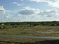
A glimpse of Encinal from Interstate 35.
-
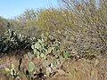
Cactus around Encinal & La Salle County
-
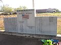
Veteran's Monument in Encinal


See also
 In Spanish: Encinal (Texas) para niños
