
Epes, Alabama facts for kids
Quick facts for kids
Epes, Alabama
|
|
|---|---|

Location of Epes in Sumter County, Alabama.
|
|
| Country | United States |
| State | Alabama |
| County | Sumter |
| Area | |
| • Total | 6.60 sq mi (17.09 km2) |
| • Land | 6.59 sq mi (17.06 km2) |
| • Water | 0.01 sq mi (0.03 km2) |
| Elevation | 164 ft (50 m) |
| Population
(2020)
|
|
| • Total | 272 |
| • Density | 41.30/sq mi (15.95/km2) |
| Time zone | UTC-6 (Central (CST)) |
| • Summer (DST) | UTC-5 (CDT) |
| ZIP code |
35460
|
| Area code(s) | 205, 659 |
| FIPS code | 01-24256 |
| GNIS feature ID | 0118012 |
Epes is a small town in Sumter County, Alabama, United States. It is located near the Tombigbee River. The town was first called Epes Station. It became an official town in 1899. In 2020, about 272 people lived there.
Contents
Where is Epes Located?
Epes is found in Sumter County, Alabama. It is close to Jones Bluff, which looks over the Tombigbee River. The town covers about 1.9 square miles (4.9 square kilometers) of land.
A Look at Epes' Past
Early Forts and Trading Posts
Epes has a long history, starting with a fort built in the 1700s. This fort was called Fort de Tombecbé. It was built by the French in 1736. The fort was on a high bluff next to the Tombigbee River.
The French used the fort to stop the British from moving west. It was also a trading post. Here, the French traded with the Choctaw people, who were their allies.
Changes in Control
After 26 years, the French gave the fort to Great Britain in 1763. The British renamed it Fort York. They used it for a few years, mainly when there were fights between Native American groups. Supplying the fort was hard because it was so far away. The British left Fort York in 1768.
Later, in the 1790s, the Spanish took control of the land. They built a new fort called Fort Confederacion. This fort helped the Spanish work with Native American groups. It also helped them against the United States. In 1798, the land, including the fort, became part of the United States. This ended the time when European countries controlled Alabama.
Epes Becomes a Town
Epes became an official town in 1899. It was named after Dr. John W. Epes. He gave land for the Southern Railroad to pass through. The town grew because of its location on the high bluffs of the Tombigbee River. People could hear ferries and steamboats on the river.
Epes was an important center for transportation and business. It had many businesses, like cotton gins and a cotton seed oil mill. There were also hotels, grocery stores, and a drug store. In 1936, the second stockyard in Alabama opened in Epes.
Who Lives in Epes?
| Historical population | |||
|---|---|---|---|
| Census | Pop. | %± | |
| 1880 | 53 | — | |
| 1900 | 331 | — | |
| 1910 | 374 | 13.0% | |
| 1920 | 722 | 93.0% | |
| 1930 | 362 | −49.9% | |
| 1940 | 328 | −9.4% | |
| 1950 | 342 | 4.3% | |
| 1960 | 337 | −1.5% | |
| 1970 | 293 | −13.1% | |
| 1980 | 399 | 36.2% | |
| 1990 | 267 | −33.1% | |
| 2000 | 206 | −22.8% | |
| 2010 | 192 | −6.8% | |
| 2020 | 272 | 41.7% | |
| U.S. Decennial Census 2013 Estimate |
|||
In 2020, the town of Epes had 272 people. Most of the people living in Epes are Black or African American. A smaller number are White.
In 2000, there were 206 people living in Epes. About 30% of homes had children under 18. The average age of people in Epes was 38 years old.
People from Epes
- Carol Forman, an actress
- Bill Oliver, a former football player and coach for the University of Alabama and other teams.
What's the Weather Like?
Epes has a warm and humid climate. Summers are hot and humid. Winters are usually mild to cool. This type of weather is called a humid subtropical climate.
Images for kids
-
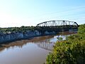
Crossing the Tenn-Tom Waterway at Epes, Alabama. You can see the railroad bridge from the U.S. Route 11 bridge.

See also
 In Spanish: Epes para niños
