Ephesus, Georgia facts for kids
Quick facts for kids
Ephesus, Georgia
|
|
|---|---|

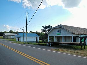
Ephesus in 2012
|
|

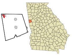
Location in Heard County and the state of Georgia
|
|
| Country | United States |
| State | Georgia |
| County | Heard |
| Area | |
| • Total | 3.69 sq mi (9.57 km2) |
| • Land | 3.69 sq mi (9.57 km2) |
| • Water | 0.00 sq mi (0.00 km2) |
| Elevation | 1,234 ft (376 m) |
| Population
(2020)
|
|
| • Total | 471 |
| • Density | 127.50/sq mi (49.22/km2) |
| Time zone | UTC-5 (Eastern (EST)) |
| • Summer (DST) | UTC-4 (EDT) |
| ZIP Code |
30170, 30108
|
| Area code(s) | 706 |
| FIPS code | 13-27708 |
| GNIS feature ID | 0355709 |
Ephesus is a small city in Heard County, Georgia, in the United States. It was first known as "Loftin". In 1964, it officially became a city and was named "Ephesus". This name came from a local church and school, which were named after the ancient biblical city of Ephesus in what is now Turkey.
In 2020, the city had a population of 471 people. Even though the city is called Ephesus, people who live there use the city names of Roopville and Bowdon for their postal addresses.
Geography of Ephesus
Ephesus is located in the northwest part of Heard County. You can find it at coordinates 33°24′18″N 85°15′35″W / 33.40500°N 85.25972°W. It is about 2 miles (3 km) east of the border with Alabama.
Georgia State Route 100 runs right through the middle of Ephesus. This road goes north for about 10 miles (16 km) to Bowdon. It also goes southeast for about 14 miles (23 km) to Franklin, which is the main town of Heard County. The closest larger city, Carrollton, is about 17 miles (27 km) to the northeast.
The United States Census Bureau says that Ephesus covers an area of about 3.0 square miles (7.8 km2). All of this area is land, with no water.
Population and People
This section tells us about the number of people living in Ephesus over time. This information comes from the census, which is an official count of the population.
| Historical population | |||
|---|---|---|---|
| Census | Pop. | %± | |
| 1970 | 212 | — | |
| 1980 | 184 | −13.2% | |
| 1990 | 324 | 76.1% | |
| 2000 | 388 | 19.8% | |
| 2010 | 427 | 10.1% | |
| 2020 | 471 | 10.3% | |
| U.S. Decennial Census | |||
In the year 2000, there were 388 people living in Ephesus. These people lived in 154 households, and 111 of those were families. By 2020, the population had grown to 471 people.
Images for kids
See also
 In Spanish: Ephesus (Georgia) para niños


