Ethel, Missouri facts for kids
Quick facts for kids
Ethel, Missouri
|
|
|---|---|

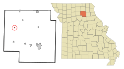
Location in Macon County and the state of Missouri
|
|
| Country | United States |
| State | Missouri |
| County | Macon |
| Area | |
| • Total | 0.23 sq mi (0.60 km2) |
| • Land | 0.23 sq mi (0.60 km2) |
| • Water | 0.00 sq mi (0.00 km2) |
| Elevation | 824 ft (251 m) |
| Population
(2020)
|
|
| • Total | 41 |
| • Density | 177.49/sq mi (68.59/km2) |
| Time zone | UTC-6 (Central (CST)) |
| • Summer (DST) | UTC-5 (CDT) |
| ZIP code |
63539
|
| Area code(s) | 660 |
| FIPS code | 29-22672 |
| GNIS feature ID | 2396929 |
Ethel is a small town located in Macon County, Missouri, in the United States. In 2020, the town had a population of 41 people. This was a decrease from 62 people counted in the 2010 census.
Contents
History of Ethel
Ethel began its story in 1888. This was when the Atchison, Topeka and Santa Fe Railway built its tracks through the area. For a short time, the town was also known by another name, "Ratliff."
A post office opened in Ethel in 1890, helping the community stay connected. However, in 2011, the U.S. Postal Service announced plans to close the Ethel post office permanently. This was part of a bigger plan to change how post offices worked across the country.
Geography of Ethel
Ethel is located in the western part of Macon County, Missouri. Missouri Route 149 is a main road that goes through the town. It is known as Oak Street and West Main Street within Ethel. If you travel south on Route 149, you will reach New Cambria about 9 miles away. Going north for about 17 miles will take you to Route 11. Macon, which is the main city of the county, is about 23 miles to the southeast.
The U.S. Census Bureau states that Ethel covers a total area of 0.23 square miles (0.60 square kilometers). All of this area is land. Water from the town flows into Little Turkey Creek, which then joins the Chariton River.
Population Changes in Ethel
| Historical population | |||
|---|---|---|---|
| Census | Pop. | %± | |
| 1900 | 397 | — | |
| 1910 | 423 | 6.5% | |
| 1920 | 329 | −22.2% | |
| 1930 | 359 | 9.1% | |
| 1940 | 317 | −11.7% | |
| 1950 | 226 | −28.7% | |
| 1960 | 149 | −34.1% | |
| 1970 | 162 | 8.7% | |
| 1980 | 145 | −10.5% | |
| 1990 | 71 | −51.0% | |
| 2000 | 100 | 40.8% | |
| 2010 | 62 | −38.0% | |
| 2020 | 41 | −33.9% | |
| U.S. Decennial Census | |||
Ethel's Population in 2010
According to the census from 2010, there were 62 people living in Ethel. These people lived in 36 different homes, and 17 of these were families. The town had 54 housing units in total.
Most of the people living in Ethel in 2010 were White, making up 98.4% of the population. A small number, 1.6%, were from two or more racial backgrounds. Also, 1.6% of the population identified as Hispanic or Latino.
Out of the 36 homes, a small number (8.3%) had children under 18 living there. About 44.4% of the homes were married couples living together. Many homes (50%) were made up of just one person. About 33.3% of all homes had someone living alone who was 65 years old or older. The average number of people in each home was about 1.72.
The average age of people in Ethel in 2010 was 60.5 years old. Only 6.5% of residents were under 18. Most residents were older adults, with 38.7% being 65 years or older. The town had slightly more males (56.5%) than females (43.5%).
See also
 In Spanish: Ethel (Misuri) para niños
 | John T. Biggers |
 | Thomas Blackshear |
 | Mark Bradford |
 | Beverly Buchanan |

