New Cambria, Missouri facts for kids
Quick facts for kids
New Cambria, Missouri
|
|
|---|---|

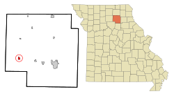
Location in Macon County and the state of Missouri
|
|
| Country | United States |
| State | Missouri |
| County | Macon |
| Area | |
| • Total | 0.68 sq mi (1.75 km2) |
| • Land | 0.67 sq mi (1.74 km2) |
| • Water | 0.00 sq mi (0.01 km2) |
| Elevation | 863 ft (263 m) |
| Population
(2020)
|
|
| • Total | 153 |
| • Density | 227.68/sq mi (87.86/km2) |
| Time zone | UTC-6 (Central (CST)) |
| • Summer (DST) | UTC-5 (CDT) |
| ZIP code |
63558
|
| Area code(s) | 660 |
| FIPS code | 29-51734 |
| GNIS feature ID | 2395188 |
New Cambria is a small city located in Macon County, Missouri, in the United States. In 2020, about 153 people lived there. This city is a quiet place in the heart of Missouri.
Contents
History of New Cambria
New Cambria was first called "Stockton" when it was founded in 1861. It was named after James Stocks, who worked for the railroad. Later, the name changed to New Cambria. "Cambria" is an old name for Wales, so "New Cambria" means "New Wales." A post office has been open in New Cambria since 1864.
A special building called the Gardner and Tinsley Filling Station was added to the National Register of Historic Places in 2002. This means it is an important historical site.
Geography and Location
New Cambria is in the southwestern part of Macon County. Missouri Route 149 goes through the city. It is known as Main Street and East Roberts Street. This route leads north about 9 miles (14 km) to Ethel.
U.S. Route 36 is just south of the city. It goes east about 15 miles (24 km) to Macon, which is the main city of the county. To the west, it goes about 18 miles (29 km) to Brookfield. The BNSF Railway also runs through the middle of the city.
Land and Water Area
The U.S. Census Bureau measures land and water areas. New Cambria has a total area of about 0.68 square miles (1.75 square kilometers). Most of this is land, about 0.67 square miles (1.74 square kilometers). Only a tiny part, about 0.003 square miles (0.01 square kilometers), is water.
The city is on a low ridge. Water from this ridge flows east towards the Chariton River. It also flows west to Puzzle Creek, which is a small stream that flows into the Chariton River.
Population and People
The population of New Cambria has changed over the years. Here is how many people have lived there during different census years:
| Historical population | |||
|---|---|---|---|
| Census | Pop. | %± | |
| 1880 | 275 | — | |
| 1890 | 410 | 49.1% | |
| 1900 | 352 | −14.1% | |
| 1910 | 387 | 9.9% | |
| 1920 | 313 | −19.1% | |
| 1930 | 360 | 15.0% | |
| 1940 | 318 | −11.7% | |
| 1950 | 295 | −7.2% | |
| 1960 | 270 | −8.5% | |
| 1970 | 260 | −3.7% | |
| 1980 | 246 | −5.4% | |
| 1990 | 223 | −9.3% | |
| 2000 | 222 | −0.4% | |
| 2010 | 195 | −12.2% | |
| 2020 | 153 | −21.5% | |
| U.S. Decennial Census | |||
2010 Census Details
In 2010, there were 195 people living in New Cambria. These people lived in 84 households, and 49 of these were families. The city had about 291 people per square mile (112 per square kilometer). There were 108 housing units in total.
Most of the people in New Cambria were White (94.4%). A small number were Native American (0.5%) or Asian (5.1%). About 3.1% of the population were Hispanic or Latino.
Households and Families
Out of the 84 households, 23.8% had children under 18 living with them. About 38.1% were married couples living together. Some households had a female head with no husband (13.1%), or a male head with no wife (7.1%). About 41.7% of households were not families.
Also, 34.5% of all households were made up of just one person. About 9.6% of households had someone living alone who was 65 years old or older. On average, there were 2.32 people in each household and 3.00 people in each family.
Age of Residents
The average age of people in the city was 37.5 years. About 21.5% of residents were under 18 years old. About 15.9% were between 18 and 24 years old. People aged 25 to 44 made up 23.6% of the population. Those aged 45 to 64 were 26.7%, and 12.3% were 65 years or older. The city had slightly more males (51.3%) than females (48.7%).
See also
 In Spanish: New Cambria (Misuri) para niños
 | Misty Copeland |
 | Raven Wilkinson |
 | Debra Austin |
 | Aesha Ash |

