Fairfield East facts for kids
Quick facts for kids Fairfield EastSydney, New South Wales |
|||||||||||||||
|---|---|---|---|---|---|---|---|---|---|---|---|---|---|---|---|

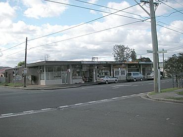
Shops in Tangerine Street
|
|||||||||||||||
| Population | 5,273 (2016 census) | ||||||||||||||
| Established | 1876 | ||||||||||||||
| Postcode(s) | 2165 | ||||||||||||||
| Elevation | 12 m (39 ft) | ||||||||||||||
| Location | 27 km (17 mi) west of Sydney CBD | ||||||||||||||
| LGA(s) | City of Fairfield | ||||||||||||||
| State electorate(s) | Fairfield | ||||||||||||||
| Federal Division(s) | Fowler | ||||||||||||||
|
|||||||||||||||
Fairfield East is a cool suburb located in Sydney, New South Wales, Australia. It's about 27 kilometers (or 17 miles) west of the main city center of Sydney. This area is part of the City of Fairfield local government area. Fairfield East is also a part of the bigger Greater Western Sydney region. It shares its postcode, 2165, with nearby suburbs like Fairfield, Fairfield Heights, and Fairfield West.
Contents
A Look Back in Time: How Fairfield East Began
Fairfield East got its name from its neighbor, Fairfield. Fairfield itself was named after the family home of Captain John Horsley, who was an early settler in the area.
The First People and Early Farms
Before European settlers arrived, the land around what is now Fairfield East was home to the Cabrogal clan. They were part of the Dharug people, who are the traditional owners of this land. In the early 1800s, British settlers moved into the area. They used the land mainly for farming.
From Farmland to a Suburb
By the 1870s, the area we know as Fairfield East was part of two large properties. The northern part was called Orchardleigh, and it stretched towards Guildford. The southern part was Mark Lodge, which also included areas like Villawood and Carramar.
In 1876, Orchardleigh was divided into smaller pieces for people to build houses. Then, in 1885, Mark Lodge was also divided up. This changed the area from farmland into a place where people lived. The name Mark Lodge was still used for a while. But by the 1950s, the area officially became known as Fairfield East.
Shops and Businesses in Fairfield East
A big part of Fairfield East, about one-fourth of it, is used for large industrial areas. These are places where factories and businesses operate. You can also find a few shops on Tangerine Street. There's also a BP petrol station on The Horsley Drive.
Right next door, in the suburb of Villawood, there are more places to visit. You can find a Bunnings Warehouse on Woodville Road. There's also a gym if you like to exercise, a McDonald's for a quick meal, and an auto repair shop for cars. These places are very close to the eastern part of Fairfield East.
Who Lives in Fairfield East?
The 2016 census counted 5,273 people living in Fairfield East. It's a very diverse place!
Where People Come From
- About 39.4% of the people were born in Australia.
- Many others came from different countries. The most common countries of birth after Australia were Vietnam (18.9%), Iraq (6.2%), Lebanon (3.6%), and China (3.3%).
Languages Spoken at Home
- Only 19.3% of people spoke only English at home.
- Many other languages are spoken, showing the suburb's rich culture. The most common languages spoken at home were Vietnamese (24.7%), Arabic (17.6%), Cantonese (4.6%), Mandarin (3.5%), and Spanish (2.5%).
Beliefs and Jobs
- The most common religions reported were Catholic (22.0%), Buddhism (20.1%), and Islam (18.0%). About 12.7% of people said they had no religion.
- People in Fairfield East work in many different jobs. The most common jobs included laborers (16.1%), professionals (14.5%), technicians and trades workers (14.2%), clerical and administrative workers (13.2%), and machinery operators and drivers (13.2%).
 | Mary Eliza Mahoney |
 | Susie King Taylor |
 | Ida Gray |
 | Eliza Ann Grier |

