Fairhaven, Minnesota facts for kids
Quick facts for kids
Fairhaven
|
|
|---|---|

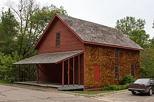
The 1867 Fair Haven Flour Mill
|
|
| Country | United States |
| State | Minnesota |
| County | Stearns |
| Township | Fair Haven Township |
| Area | |
| • Total | 2.05 sq mi (5.32 km2) |
| • Land | 1.91 sq mi (4.94 km2) |
| • Water | 0.15 sq mi (0.38 km2) |
| Elevation | 1,073 ft (327 m) |
| Population
(2020)
|
|
| • Total | 392 |
| • Density | 205.45/sq mi (79.32/km2) |
| Time zone | UTC-6 (Central (CST)) |
| • Summer (DST) | UTC-5 (CDT) |
| ZIP code |
55382
|
| Area code(s) | 320 |
| GNIS feature ID | 2628676 |
Fairhaven is a small community in Minnesota, United States. It is located in Stearns County and is known as an unincorporated community. This means it's a recognized area where people live, but it doesn't have its own separate city government. Fairhaven is also a census-designated place (CDP), which is a special area the government uses to count people for the census. In 2020, about 392 people lived in Fairhaven.
Where is Fairhaven?
Fairhaven is found in Fair Haven Township, which is part of Stearns County, Minnesota. You can find it near where Stearns County Roads 7 and 44 meet. Other towns close to Fairhaven include Kimball, South Haven, Clearwater, and St. Augusta. Stearns County Road 45 is also nearby.
A Glimpse into History
Fairhaven has an interesting historical building. The 1867 Fair Haven Flour Mill is a very old building in the community. It is so important that it is listed on the National Register of Historic Places. This list helps protect special places in the United States.
How Many People Live Here?
The number of people living in Fairhaven changes over time. Here's a quick look at its population:
- In 2010, there were 358 people.
- By 2020, the population grew to 392 people.
See also
 In Spanish: Fairhaven (Minnesota) para niños
 | Ernest Everett Just |
 | Mary Jackson |
 | Emmett Chappelle |
 | Marie Maynard Daly |


