
Falcon Heights, Minnesota facts for kids
Quick facts for kids
Falcon Heights, Minnesota
|
|
|---|---|

Falcon Heights City Hall
|
|
| Nickname(s):
"The City That Soars"
|
|
| Motto(s):
"Families, Fields and Fair"
|
|

Location of Falcon Heights in Ramsey County, Minnesota
|
|
.png)
Falcon Heights on The National Map
|
|
| Country | United States |
| State | Minnesota |
| County | Ramsey |
| Settled | 1843 |
| Incorporated (village) | April 1, 1949 |
| Incorporated (city) | 1973 |
| Area | |
| • Total | 2.240 sq mi (5.802 km2) |
| • Land | 2.233 sq mi (5.783 km2) |
| • Water | 0.007 sq mi (0.019 km2) |
| Elevation | 961 ft (293 m) |
| Population
(2020)
|
|
| • Total | 5,369 |
| • Estimate
(2023)
|
4,984 |
| • Density | 2,232/sq mi (861.8/km2) |
| Time zone | UTC–6 (Central (CST)) |
| • Summer (DST) | UTC–5 (CDT) |
| ZIP Codes |
55108, 55113
|
| Area code(s) | 651 612 (U of M campus only) |
| FIPS code | 27-20420 |
| GNIS feature ID | 2394738 |
| Sales tax | 8.375% |
Falcon Heights is a city in Ramsey County, Minnesota, United States. It's a suburb located near Saint Paul. In 2020, about 5,369 people lived there.
Falcon Heights started as a village on April 1, 1949. It officially became a city in 1973. It is home to the University of Minnesota's St. Paul Campus. This campus includes places like the Goldstein Museum of Design and the Gabbert Raptor Center. The city also hosts the famous Minnesota State Fairgrounds.
Contents
History of Falcon Heights
How Falcon Heights Began
A man named Heman Gibbs settled in this area in the 1850s. His old home is now a museum. It is also listed as a historic place.
In the 1930s, a real estate agent named Faulkner developed land here. He named the new area "Falcon Heights" after himself. The very first house was built in 1937.
Becoming a City
In 1949, the people living in Falcon Heights made a big decision. They voted to become their own village. They did not want to join nearby cities like Roseville or St. Paul.
When Falcon Heights grew, it included important public lands. These included the University of Minnesota Golf Course and the Minnesota State Fairgrounds. Today, about two-thirds of Falcon Heights is public land.
Early Aviation in the Area
Between the 1910s and 1930s, an airport called Curtiss Northwest Airport was in this area. It was located where Snelling and Larpenteur Avenues meet today. This airfield was very important for early aviation in Minnesota. Famous pilots like Charles Lindbergh flew from here. Part of the land is now a city park called Curtiss Field.
Parks and Recreation
Falcon Heights has several parks for everyone to enjoy.
- Falcon Heights Community Park: This park offers sports activities in the summer. In winter, it has an ice rink and a warming house. There's also a soccer field and a fitness course.
- Curtiss Field: This park is named after the old airport. It also offers recreational sports.
- Grove Park: Located in the University Grove neighborhood, this park has a temporary ice rink and warming house in the winter.
Geography and Climate
Where is Falcon Heights?
Falcon Heights is a small city. It covers about 2.24 square miles (5.8 square kilometers). Most of this area is land. Only a tiny part is water.
A main road in the city is Minnesota Highway 51, also known as Snelling Avenue. Falcon Heights is surrounded by other towns. Lauderdale is to the west. St. Paul is to the south and east. Roseville is to the north and east.
Weather in Falcon Heights
The weather in Falcon Heights changes a lot with the seasons. Summers are warm, and winters are cold and snowy.
| Climate data for University of Minnesota St. Paul (1991–2020 normals, extremes 1963–present) | |||||||||||||
|---|---|---|---|---|---|---|---|---|---|---|---|---|---|
| Month | Jan | Feb | Mar | Apr | May | Jun | Jul | Aug | Sep | Oct | Nov | Dec | Year |
| Record high °F (°C) | 55 (13) |
62 (17) |
82 (28) |
91 (33) |
100 (38) |
101 (38) |
105 (41) |
105 (41) |
95 (35) |
90 (32) |
77 (25) |
67 (19) |
105 (41) |
| Mean maximum °F (°C) | 42.0 (5.6) |
46.4 (8.0) |
63.0 (17.2) |
77.9 (25.5) |
87.5 (30.8) |
92.2 (33.4) |
92.8 (33.8) |
91.0 (32.8) |
87.4 (30.8) |
80.2 (26.8) |
61.9 (16.6) |
46.2 (7.9) |
95.1 (35.1) |
| Mean daily maximum °F (°C) | 21.2 (−6.0) |
26.5 (−3.1) |
39.4 (4.1) |
54.7 (12.6) |
67.1 (19.5) |
77.2 (25.1) |
81.4 (27.4) |
79.1 (26.2) |
71.3 (21.8) |
57.3 (14.1) |
40.1 (4.5) |
26.4 (−3.1) |
53.5 (11.9) |
| Daily mean °F (°C) | 13.3 (−10.4) |
17.9 (−7.8) |
30.9 (−0.6) |
45.2 (7.3) |
57.7 (14.3) |
67.9 (19.9) |
72.1 (22.3) |
69.8 (21.0) |
61.8 (16.6) |
48.1 (8.9) |
32.6 (0.3) |
19.5 (−6.9) |
44.7 (7.1) |
| Mean daily minimum °F (°C) | 5.5 (−14.7) |
9.4 (−12.6) |
22.3 (−5.4) |
35.6 (2.0) |
48.2 (9.0) |
58.5 (14.7) |
62.8 (17.1) |
60.5 (15.8) |
52.2 (11.2) |
38.9 (3.8) |
25.2 (−3.8) |
12.5 (−10.8) |
36.0 (2.2) |
| Mean minimum °F (°C) | −15.4 (−26.3) |
−10.2 (−23.4) |
0.9 (−17.3) |
20.9 (−6.2) |
34.4 (1.3) |
45.4 (7.4) |
52.4 (11.3) |
50.1 (10.1) |
36.2 (2.3) |
24.5 (−4.2) |
8.9 (−12.8) |
−8.2 (−22.3) |
−17.8 (−27.7) |
| Record low °F (°C) | −30 (−34) |
−32 (−36) |
−18 (−28) |
1 (−17) |
23 (−5) |
36 (2) |
44 (7) |
39 (4) |
26 (−3) |
15 (−9) |
−15 (−26) |
−27 (−33) |
−32 (−36) |
| Average precipitation inches (mm) | 0.68 (17) |
0.75 (19) |
1.61 (41) |
3.02 (77) |
4.23 (107) |
4.60 (117) |
4.55 (116) |
4.52 (115) |
3.29 (84) |
2.89 (73) |
1.53 (39) |
1.06 (27) |
32.73 (831) |
| Average snowfall inches (cm) | 8.3 (21) |
12.3 (31) |
4.0 (10) |
2.1 (5.3) |
0.0 (0.0) |
0.0 (0.0) |
0.0 (0.0) |
0.0 (0.0) |
0.0 (0.0) |
0.5 (1.3) |
3.0 (7.6) |
10.2 (26) |
40.4 (103) |
| Average precipitation days (≥ 0.01 in) | 7.0 | 5.8 | 8.5 | 10.4 | 13.1 | 12.7 | 11.3 | 10.8 | 10.9 | 10.4 | 7.1 | 7.5 | 115.5 |
| Average snowy days (≥ 0.1 in) | 4.2 | 3.6 | 2.2 | 1.1 | 0.1 | 0.0 | 0.0 | 0.0 | 0.0 | 0.4 | 1.8 | 4.2 | 17.6 |
| Source: NOAA | |||||||||||||
People of Falcon Heights
| Historical population | |||
|---|---|---|---|
| Census | Pop. | %± | |
| 1950 | 3,884 | — | |
| 1960 | 5,927 | 52.6% | |
| 1970 | 5,530 | −6.7% | |
| 1980 | 5,291 | −4.3% | |
| 1990 | 5,380 | 1.7% | |
| 2000 | 5,572 | 3.6% | |
| 2010 | 5,321 | −4.5% | |
| 2020 | 5,369 | 0.9% | |
| 2023 (est.) | 4,984 | −6.3% | |
| U.S. Decennial Census 2020 Census |
|||
In 2020, Falcon Heights had 5,369 people living there. There were 2,203 households. The city's population density was about 2,404 people per square mile.
Most people in Falcon Heights are White (68.4%). Other groups include African American (10.1%) and Asian (12.8%). About 3.4% of the population was Hispanic or Latino.
Education in Falcon Heights
The schools in Falcon Heights are part of the Roseville Area School District. Falcon Heights Elementary is the only school right inside the city. This elementary school has a park with two playgrounds. One of the playgrounds was built in 2006.
Images for kids
-
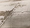
Snelling and Larpenteur Avenues in 1920
-
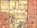
1951 map of Falcon Heights

.png)
See also
 In Spanish: Falcon Heights (Minnesota) para niños
