Farm River (Connecticut) facts for kids
Quick facts for kids Farm River |
|
|---|---|

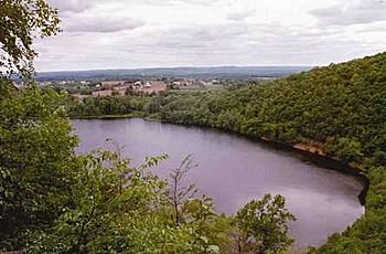
Pistapaug Pond,
one of the sources of the Farm River |
|
| Other name(s) | (Also called East Haven River and other names) |
| Country | United States |
| State | Connecticut |
| County | New Haven |
| Towns | East Haven, Branford, North Branford |
| Physical characteristics | |
| Main source | North Branford, Connecticut, United States 345 ft (105 m) (41°25′23″N 72°44′16″W / 41.4231531°N 72.7378745°W) |
| River mouth | Long Island Sound, New Haven County, Connecticut, United States 0 ft (0 m) (41°14′51″N 72°51′33″W / 41.2475970°N 72.8592667°W) |
| Length | 16.5 mi (26.6 km) |
The Farm River is a river in the state of Connecticut in the United States. It flows south and is about 16.5 miles (26.6 km) (26.6 km) long. The river starts as freshwater in the northern part of Connecticut. It then flows into Long Island Sound, which has salt water. Because it mixes fresh and salt water, the Farm River is called an estuary.
Where Does the Farm River Flow?
The Farm River begins in the northern part of North Branford. From there, it flows south. As it continues, the river becomes a natural border. It separates the towns of East Haven and Branford.
Along its path, the river helps supply water to Lake Saltonstall. This lake is an important source of public drinking water. It is managed by the South Central Connecticut Regional Water Authority. Near where the river meets the ocean, it flows past Farm River State Park. This park is a great place to visit.
Other Names for the Farm River
The Farm River has been known by many different names over time. The U.S. Geological Survey (USGS) lists several of these. Some of the other names include Beaver River, East Haven River, and Muddy River. People also called it Deborah River, Foxon River, and Great River. Other names were Ironworks River, Mainnuntaquck, Moe River, Scotch Cap River, Stony River, and Tapamshasick. The name "Farm River" was officially chosen in 1968.
 | Kyle Baker |
 | Joseph Yoakum |
 | Laura Wheeler Waring |
 | Henry Ossawa Tanner |


