
Faubourg Marigny facts for kids
Quick facts for kids
Marigny
|
|
|---|---|
|
New Orleans neighborhood
|
|

Residential architecture in Faubourg Marigny
|
|
| Country | United States |
| State | Louisiana |
| City | New Orleans |
| Planning District | District 7, Bywater District |
| Named for | Bernard de Marigny |
| Area | |
| • Total | 0.3378 sq mi (0.875 km2) |
| • Land | 0.31 sq mi (0.8 km2) |
| • Water | 0.02 sq mi (0.05 km2) |
| Elevation | 1 ft (0.3 m) |
| Population
(2010)
|
|
| • Total | 2,128 |
| • Density | 6,299.6/sq mi (2,432.3/km2) |
| Time zone | UTC-6 (CST) |
| • Summer (DST) | UTC-5 (CDT) |
| Area code(s) | 504 |

The Faubourg Marigny (pronounced FOH-burg MAYR-in-ee), often called The Marigny, is a vibrant neighborhood in the city of New Orleans, Louisiana, United States. It's known for its unique history, colorful buildings, and lively music scene.
The neighborhood's official borders are North Rampart Street and St. Claude Avenue to the north. To the east, you'll find the railroad tracks along Homer Plessy Way (which used to be called Press Street). The mighty Mississippi River forms its southern edge, and Esplanade Avenue is its western boundary.
Contents
Exploring Faubourg Marigny's Location
Faubourg Marigny is located at about 29°57′53″N 90°03′19″W. It sits just 1 foot (0.3 meters) above sea level. The neighborhood covers an area of about 0.33 square miles (0.85 square kilometers). Most of this area is land, with a small part (about 6%) being water.
Historic Divisions of Marigny
In the 1800s, Faubourg Marigny was part of the Third Municipality of New Orleans. A special triangular area between Esplanade and Elysian Fields Avenue is sometimes called the Marigny Triangle. This part is in the 7th Ward of New Orleans. The rest of the neighborhood is in the 8th and 9th wards of New Orleans.
Neighboring Communities
Faubourg Marigny is surrounded by other interesting neighborhoods:
- Seventh Ward (to the north)
- St. Roch (to the north)
- Bywater (to the east)
- French Quarter (to the west)
Understanding Marigny's Borders
The City Planning Commission officially defines the boundaries of Faubourg Marigny. These are North Rampart Street, St. Claude Avenue, the railroad tracks along Homer Plessy Way, the Mississippi River, and Esplanade Avenue.
The South 7th Ward Area
In 2013, a specific part of the neighborhood was named the South 7th Ward. This area is bordered by N. Claiborne Avenue, Elysian Fields Avenue, St. Claude Avenue, and St. Bernard Avenue. Residents voted to give it this name.
Discovering New Marigny
The area further away from the river, stretching towards I-10, is known as New Marigny. This name has been used since the early 1800s. The border with the Bywater neighborhood is usually considered to be Press Street (where the railroad tracks are) or Franklin Avenue.
The New Marigny Historic District was added to the National Register of Historic Places in 1994. This means it's a special area recognized for its important history and buildings. It includes parts of the 7th and 8th wards, as well as other historic areas like Faubourg Saint Roch and Faubourg Saint Claude.

A Look at Marigny's Past
Faubourg Marigny was once part of a large plantation. It was developed by a wealthy landowner named Bernard de Marigny. He started dividing his land and selling lots in 1806, creating the Faubourg Marigny. These lots sold so fast that he expanded the development just four years later. Sales became even faster in 1831 when the Pontchartrain Railroad, nicknamed “Smoky Mary,” started running on Elysian Fields Avenue. This made it easier for people to get around.
Development continued downriver from Elysian Fields Avenue when Faubourg Franklin was created in 1834. These neighborhoods, including parts of Faubourg Marigny across St. Claude Avenue, were mainly settled by Louisiana Creoles of color and German immigrants between the 1830s and 1880s.
Famous Musicians from Marigny
Many famous musicians either grew up in this neighborhood or moved here later in life.
- Ferdinand LaMothe, known as Jelly Roll Morton, would secretly play piano in Storyville.
- Sidney Bechet, Manny Perez, Danny Barker, and Paul Barbarin, all legends of New Orleans music, lived in the neighborhood.
Marigny Today: Culture and Community
In the 21st century, Faubourg Marigny is home to lively music spots like the Saturn Bar on St. Claude Avenue. It also has historic places like the St. Roch Market, which is one of the last public market buildings left in New Orleans. The independent Circle Market on St. Bernard Avenue is still doing well, even with big grocery stores nearby.
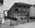
Beautiful old oak trees line St. Roch and Elysian Fields avenues. Many traditional Creole cottages and shotgun houses are being fixed up and painted, adding to the neighborhood's charm. A new public park is also being built in the area that used to be industrial, along the Press Street corridor.
Who Lives in Marigny?
In 2000, about 3,145 people lived in Faubourg Marigny, with 1,960 households. By 2010, the population was 2,973 people, living in 1,881 households.
Marigny's Rich History
How Marigny Began in the 1800s
Faubourg Marigny was created in the early 1800s by Creole real estate developer and politician Bernard de Marigny. It was built on land that used to be his family's plantation. This land was just downriver from the old city limits of New Orleans.
The part of Faubourg Marigny closer to the river was built first. The area on the other side of St. Claude Avenue (which was once called "Goodchildren Street") was sometimes known as New Marigny.
Elysian Fields Avenue is a wide street named after the Champs-Élysées in Paris. It was designed to be the main street of the faubourg. It was also the first street in New Orleans to go straight from the riverfront all the way to Lake Pontchartrain, about 8 kilometers (5 miles) away. In 1830-1831, the Pontchartrain Railroad was built with its tracks running down the middle of Elysian Fields.
Marigny in the 1900s and Beyond


The neighborhood saw some tough times in the mid-1900s. After Hurricane Betsy in 1965, many Filipino Americans who lost their homes moved to the neighborhood. Faubourg Marigny made a strong comeback in the late 1900s.
When the 1984 World's Fair happened, many people who had lived in the French Quarter for a long time moved to Marigny. Frenchmen Street became one of the city's best places for live music and restaurants. It's a popular spot for music lovers. The neighborhood is also home to the New Orleans Center for Creative Arts, a special school for young artists.
Faubourg Marigny is one of New Orleans' most colorful neighborhoods. Its buildings mix styles from French and Spanish colonial times with Caribbean influences. This blend of cultures has created a truly unique look. Marigny is also a key spot for local New Orleans Mardi Gras celebrations, known for its creative costumes.
Recovering After Hurricane Katrina
Hurricane Katrina hit New Orleans hard in August 2005. However, Faubourg Marigny was not as badly affected as other areas. The part of the neighborhood closer to the Mississippi River had some wind damage but was high enough to avoid the major flooding. The lower areas of New Marigny did flood, but not as deeply as other parts of the city. Many of the old 19th-century houses were built on raised foundations, which helped protect them from serious flood damage, even as far back as Claiborne Avenue.
After the storm, a free community kitchen and goods-exchange camp was set up in Washington Square for a few months. The official reopening of Marigny was delayed because areas were reopened by ZIP code, and Faubourg Marigny shared a ZIP code with more heavily damaged areas. Once it reopened, the neighborhood recovered quickly.
Learning in Marigny
The neighborhood is part of the New Orleans Public Schools district. The building that used to be Colton Middle School in Faubourg Marigny is now a Knowledge Is Power Program (KIPP) charter school, part of the KIPP New Orleans Schools network.
Notable People from Marigny
- Jelly Roll Morton (1890–1941), a famous jazz composer and musician.
- Lizzie Miles (1895–1963), a talented singer.
Images for kids
-
1979 photograph of 2519 Dauphine Street

