Ferndale, Michigan facts for kids
Quick facts for kids
Ferndale, Michigan
|
|
|---|---|
| City of Ferndale | |
|
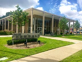
Top-to-bottom: Downtown Ferndale looking south toward Detroit, Ferndale City Hall
|
|

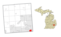
Location within Oakland County
|
|
| Country | United States |
| State | Michigan |
| County | Oakland |
| Incorporated | 1918 (village) 7 March 1927 (city) |
| Government | |
| • Type | Council–manager |
| Area | |
| • City | 3.88 sq mi (10.04 km2) |
| • Land | 3.88 sq mi (10.04 km2) |
| • Water | 0.00 sq mi (0.00 km2) |
| Elevation | 646 ft (197 m) |
| Population
(2020)
|
|
| • City | 19,190 |
| • Density | 4,949.70/sq mi (1,911.03/km2) |
| • Metro | 4,392,041 (Metro Detroit) |
| Time zone | UTC-5 (EST) |
| • Summer (DST) | UTC-4 (EDT) |
| ZIP code(s) |
48220
|
| Area code(s) | 248 |
| FIPS code | 26-27880 |
| GNIS feature ID | 0625911 |
Ferndale is a city in Michigan, located in Oakland County. It is a suburb of Detroit, about 10 miles (16 km) northwest of downtown Detroit. In 2020, about 19,190 people lived there.
Ferndale is known for its lively downtown area. It is also a place where many different people feel welcome and included.
Contents
Ferndale's History
Early Days and Growth
Long ago, Native American people lived in the area that is now Ferndale. In the 1800s, farmers started growing crops on the land.
When cars were invented and assembly lines made them quickly, more and more people moved to Ferndale. It became a village in 1918. Then, on March 7, 1927, the people voted for Ferndale to become a city.
A Home for Workers
Ferndale grew as a bedroom community for people working in Detroit. Most of its homes were built between 1920 and 1951.
In the early 1950s, trolley lines ran along Woodward Avenue. These trolleys helped the northern suburbs grow. People could easily travel to Detroit for shopping or work.
Family Life in the 1970s
In the 1970s, Ferndale was a popular place for families to raise children during the "Baby Boom" era. It had elementary schools, parks, churches, and community groups. Ferndale High School was finished in 1958.
Downtown Revival
Ferndale's main shopping area, 9 Mile Road, was very busy from the 1940s to the 1960s. Later, many businesses closed.
However, in recent years, the downtown area has become lively again. Ferndale's downtown is centered around Nine Mile Road and Woodward Avenue. Around 1997, the city made West Nine Mile Road more friendly for people walking. They made it one lane in each direction and added street parking. This brought more people and new stores and restaurants.
The city has also added bicycle lanes to Hilton Road and Pinecrest Road. This makes it easier for people to get around by bike.
Where is Ferndale?
Ferndale covers about 3.88 square miles (10.04 square kilometers) of land.
It is next to several other cities:
- Detroit to the south
- Oak Park to the west
- Hazel Park to the east
- Pleasant Ridge to the north
- Royal Oak Township to the southwest
- Royal Oak to the north
Ferndale's borders include:
- 8 Mile Road to the south
- Oakridge Street (west of Woodward Avenue) and 10 Mile Road and I-696 (east of Woodward Avenue) to the north
- Republic Street (south of Nine Mile Road) and Hyland Street (north of Nine Mile) to the west
- West End, Pilgrim Street, and Lennox Street to the east
People of Ferndale
| Historical population | |||
|---|---|---|---|
| Census | Pop. | %± | |
| 1920 | 2,640 | — | |
| 1930 | 20,855 | 690.0% | |
| 1940 | 22,523 | 8.0% | |
| 1950 | 29,675 | 31.8% | |
| 1960 | 31,347 | 5.6% | |
| 1970 | 30,850 | −1.6% | |
| 1980 | 26,227 | −15.0% | |
| 1990 | 25,084 | −4.4% | |
| 2000 | 22,105 | −11.9% | |
| 2010 | 19,900 | −10.0% | |
| 2020 | 19,190 | −3.6% | |
| U.S. Decennial Census | |||
Population in 2010
In 2010, there were 19,900 people living in Ferndale. There were 9,559 households. The city had about 5,129 people per square mile (1,980 per square kilometer).
Most residents (84.7%) were White. About 9.6% were African American, and 1.3% were Asian. People of Hispanic or Latino background made up 2.8% of the population.
The average age in Ferndale was 35.6 years old. About 16.5% of residents were under 18. About 41.2% were between 25 and 44 years old.
A Welcoming Community
In the 1980s and 1990s, more people from diverse backgrounds moved to Ferndale. They came from Detroit and other nearby towns like Royal Oak and Pleasant Ridge.
In 2006, Ferndale passed a rule to protect people from unfair treatment in public places, housing, and businesses. This rule was supported by 70% of the voters.
Affirmations is a large community center in downtown Ferndale. It opened its new building in 2007. That same year, Ferndale elected the first openly gay mayor in Michigan.
The Motor City Pride festival moved to Ferndale in 2001. In 2011, it moved to Detroit. That year, the Ferndale Pride festival started in Ferndale.
Education in Ferndale
Ferndale has its own school district called Ferndale Public Schools. This includes elementary, middle, and high schools. Ferndale High School and University High School are part of this district. A small part of Ferndale is in the Hazel Park Schools district instead.
Famous People from Ferndale
Many notable people have connections to Ferndale:
- James Blanchard: Former Governor of Michigan and U.S. Ambassador to Canada.
- Joseph Bruce (a.k.a. Violent J): A member of the music group Insane Clown Posse.
- Ron Carter: A famous jazz musician.
- Dana Elcar: An actor known for the movie The Sting and the TV show MacGyver.
- Elena Ford: An heiress.
- Frank Hagel: A painter and sculptor.
- Josh Malerman: A novelist and singer-songwriter.
- Rashad Phillips: A professional basketball player who played for Ferndale High School.
- Ken Rowe: A former MLB pitcher and coach, born in Ferndale.
- The Spinners: An American R&B music group that formed in Ferndale.
- Bob Welch: A former MLB pitcher who won the Cy Young Award in 1990. He lived in Ferndale.
See also
In Spanish: Ferndale (Míchigan) para niños


