
Finedon Top Lodge Quarry facts for kids
| Site of Special Scientific Interest | |
 |
|
| Area of Search | Northamptonshire |
|---|---|
| Interest | Geological 168.1–166.1Ma |
| Area | 0.9 hectares |
| Notification | 1986 |
| Location map | Magic Map |
Finedon Top Lodge Quarry, also known as Finedon Gullet, is a special place in Northamptonshire, England. It's a 0.9-hectare area that's important for geology, which is the study of Earth's rocks and history. This site is officially called a Site of Special Scientific Interest (SSSI) because it shows amazing rock layers from the Middle Jurassic period.
The quarry was created by digging for ironstone, a type of rock used to make iron and steel. This ironstone was sent to steelworks in nearby Wellingborough and Corby using a special narrow-gauge railway called the Wellingborough Tramway.
Contents
Understanding the Rocks at Finedon Gullet
Finedon Top Lodge Quarry is like a giant history book made of rock. It shows us layers of rock that formed between 168 and 166 million years ago, during the Middle Jurassic period. This was a time when dinosaurs roamed the Earth!
The rocks here are mostly limestones, sandstones, and ironstones. They tell us about ancient seas and landscapes that once covered this area.
What is a Type Section?
Finedon Gullet is the "type section" for a group of rocks called the 'Wellingborough Member'. This means it's the best place to see and study these specific rock layers, and geologists use it as a reference point.
Layers of Time: The Geology of the Quarry
The rock face at Finedon Gullet shows different layers, each telling a story about the past. Here are some of the main rock units you can find:
- Blisworth Limestone Formation: This is a widespread limestone layer found across Northamptonshire. It formed in a fully marine (saltwater) sea.
- Rutland Formation: This includes various layers of limestones, sands, silts, and clays.
- Wellingborough Limestone Member: This is a series of mud and limestone beds. It's special because Finedon Gullet is its 'type section'. These rocks often contain lots of fossilized oyster shells.
- Stamford Member: This layer consists of muddy clays and sandy silts, sometimes with ironstone lumps.
- Northampton Sand Formation: This is where the ironstone comes from. It's the oldest rock layer visible at the quarry.
Missing Time: The Unconformity
Between some of the rock layers, like the Bajocian and Aalenian ages, there's a big gap. This is called an unconformity. It means that for several million years, either no new rocks were laid down, or existing rocks were worn away by erosion. It's like pages are missing from our rock history book!
The Oldest Rocks: Ironstone
The lowest and oldest rocks at Finedon Gullet are part of the Northampton Sand Formation. These rocks are a deep brown color and were formed in shallow seas during the Aalenian Age, about 174 to 170 million years ago.
This ironstone was too deep to be used for building houses, but it was perfect for making iron and steel. That's why this quarry was dug – to get to these valuable iron-rich rocks.
The Wellingborough Limestone Story
The Stamford Member, Wellingborough Member, and Cranford rhythm layers sit right on top of the ironstone, even though there's a 2-million-year gap in time between them!
During the Aalenian Age, the area was covered by shallow seas. But then, during the Bajocian Age, the sea disappeared, and the land became dry. No new sediments were laid down.
When the sea returned in the Early Bathonian Age, new sediments started to form. The Stamford Member, for example, formed in a freshwater lake on a coastal plain. Later, the Finedon Quarry area became a brackish lagoon (a mix of fresh and saltwater). Sometimes the lagoon was deeper, forming marine limestone, and sometimes it was shallower, allowing plants to grow. This created the rhythmic layers of limestone and rootlet beds seen in the Wellingborough Member.
The Blisworth Limestone: A Widespread Layer
The Blisworth Limestone Formation is a thick series of limestone beds found all across Northamptonshire. It formed in a fully marine saltwater sea at the end of the Bathonian Age. At this time, the lagoons were once again covered by the sea.
This limestone has been widely used for building stone in the area. It's usually cream or beige, unlike the dark brown ironstone.
The Finedon Gullet rock face shows two parts of the Blisworth Limestone:
- Sharpi Beds: These lower beds have lots of shells and fossils, including oysters and a special fossil called Sharpirhynchia sharpi. This fossil is named after Samuel Sharp (geologist), a geologist who studied these quarries in the 1800s.
- Digonoides Beds: Above the Sharpi beds, there are about 4 meters of limestone. The lower part has fossils, but the upper part has fewer or no fossils.
Above the limestone, there's a layer of Blisworth Clay Formation. After this, there are no more rock layers preserved for the next 166 million years!
How the Quarry Was Dug
Finedon Gullet is a long, cliff-like feature created by digging out the ironstone and the rocks above it. Since digging stopped, the bottom of the cliff has filled with debris, and a long pond has formed.
Quarrying for ironstone in the Finedon area began in the 1860s and continued for 100 years. By the mid-1960s, Finedon Top Lodge Quarry was being worked by a company called Stewarts & Lloyds Ltd. They used the ironstone for their steelworks in Corby. The Wellingborough Tramway carried the iron ore from this and other nearby quarries to the steelworks.
Digging Methods
Early quarries moved all the rock by hand, using wheelbarrows and planks. But by the 1920s, when Finedon Top Lodge Quarry was likely opened, machines were used. Quarries started using huge dragline excavators to dig out the rock faster and with fewer workers. In fact, in 1940, Finedon Top Lodge Quarry was the first place in Britain to use a special type of machine called a walking dragline excavator!
Visiting Finedon Gullet
The quarry face itself is on private land, so you can't go right up to it. However, a public footpath runs by the eastern end of the site, allowing you to see parts of this interesting geological area.
Images for kids
-

This diagram shows the main rock formations across Northamptonshire. The grey box shows where Finedon Top Lodge Quarry fits in.
-
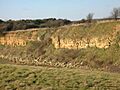
The Finedon Gullet cliff face in 2006. The lower rock layers are now covered by debris.

