Fir Clump Stone Circle facts for kids

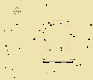
Diagram of Fir Clump Stone Circle, based on Richard Reiss's 1965 measurements. The black marks represent stones recorded in the vicinity; the red lines demarcate the concentric rings of the putative circle.
|
|
| Location | Near Wroughton |
|---|---|
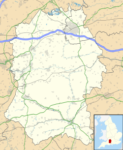
| Coordinates | 51°31′57″N 01°45′59″W / 51.53250°N 1.76639°W |
| Type | Stone circle |
| History | |
| Periods | Neolithic / Bronze Age |
The Fir Clump Stone Circle was an ancient stone circle located in Burderop Wood near Wroughton, Wiltshire, in South West England. This circle was part of a widespread tradition of building stone circles. These circles were built across much of Britain, Ireland, and Brittany (in France). This happened during the late Neolithic (Stone Age) and early Bronze Age, from about 3300 to 900 BCE.
We don't know exactly why these ancient monuments were built. Some archaeologists think the stones might have represented special spirits or gods to the people who built them.
Fir Clump Stone Circle was made of large sarsen stones arranged in two oval-shaped rings, one inside the other. The outer ring was about 107 meters (351 feet) long and 86.5 meters (284 feet) wide. The inner ring was 86.5 meters (284 feet) long and 73.7 meters (242 feet) wide. It was one of at least seven stone circles built in the area south of Swindon in northern Wiltshire.
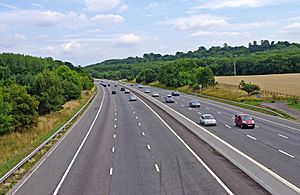
Sadly, around the 1860s, the stones of Fir Clump Stone Circle were knocked down. By the 1890s, an expert named A. D. Passmore noted that the circle could no longer be seen. In 1965, some of the fallen stones were found again by archaeologist Richard Reiss. He drew maps and measured the site. However, in 1969, these stones were removed when the M4 motorway was being built.
What are Stone Circles?
During the fourth and third millennia BCE, there were big changes in the types of monuments people built in southern and eastern England. By 3000 BCE, older monuments like long barrows (long burial mounds) were no longer being constructed. Instead, people started building circular monuments. These included earthen henges, timber circles (made of wood), and stone circles.
Stone circles can be found in most parts of Britain where there was enough stone. They are especially common in south-western Britain and north-eastern Scotland. People built these circles for a very long time, possibly for 2,400 years. The main period of building was between 3000 and 1300 BCE.
Historian Ronald Hutton observed that these stone circles often show little sign of people visiting them right after they were built. This suggests they might not have been places for noisy rituals. Instead, they might have been left as "silent and empty monuments."
Archaeologist Mike Parker Pearson believes that in ancient Britain, stone was linked to the dead, while wood was linked to the living. Other archaeologists think the stones might have represented not just ancestors, but also other powerful beings, like gods.
Many stone circles were built in the area of modern Wiltshire. The most famous ones are Avebury and Stonehenge. Many other circles in Wiltshire are now ruined or have been completely destroyed. As archaeologist Aubrey Burl noted, these lost circles leave behind "only frustrating descriptions and vague positions." Most known Wiltshire circles were built in low-lying areas.
In the area south of Swindon, there might have been as many as seven stone circles. These include Fir Clump Stone Circle, Swindon Old Church Stone Circle, Broome Stone Circle, Day House Lane Stone Circle, Coate Reservoir Stone Circle, Hodson Stone Circle, and Winterbourne Bassett Stone Circle. These circles were often quite close to each other. For example, Fir Clump Stone Circle was only about a mile south of the Broome Stone Circle. All of these northern Wiltshire circles have been destroyed. However, some fallen stones from the Day House Lane Stone Circle in Coate can still be seen.
What Did Fir Clump Stone Circle Look Like?
Fir Clump Stone Circle was made of rough sarsen stones. These stones were arranged to form two concentric (one inside the other) circles. Archaeologists David Field and David McOmish noted that the circle seemed "slightly oval in outline."
The outer ring was partly broken. It measured about 107 meters (351 feet) by 86.5 meters (284 feet) across. The inner ring measured 86.5 meters (284 feet) by 73.7 meters (242 feet). This inner ring was flatter on its northern side.
About 125 meters (410 feet) to the west of the circle, there was a line of stones. This stone row was 102 meters (335 feet) long. It ran from the north/north-west to the south/south-east. The fact that Fir Clump Stone Circle had two concentric rings is similar to the Winterbourne Bassett Stone Circle. The Coate Reservoir Stone Circle might also have had a double ring.
How Was Fir Clump Stone Circle Found and Lost?
In the late 1800s, an antiquarian (someone who studies old things) named A. D. Passmore wrote two notebooks. In these notebooks, he described archaeological sites in Wiltshire. He wrote about a local story that there was a large stone circle near the railway bridge outside Swindon Old Town. This was also near the old Marlborough road to Ladder Hill.
Passmore noted that the circle had been broken up about 30 years before he wrote about it. So, he didn't know how many stones it originally had. He also mentioned that many small pieces of sarsen stone could be found at the site. Passmore's notebooks were not published until 2004. The Wiltshire Archaeological and Natural History Society bought them.
In an article from 1894, Passmore briefly mentioned "a number of sarsens" at Hodson, which is next to Burderop Wood. He thought these might have been part of a circle. He also said a line of stones seemed to go from this circle towards Coate. In 2000, Aubrey Burl thought this description referred to the Fir Clump ring. However, Passmore's notebooks, published later, showed that he saw Fir Clump and Hodson as separate circles.
Fir Clump Stone Circle was rediscovered in 1965 by a surveyor named Richard Reiss. He saw that the sarsen stones were all fallen over. He then created a map of the site as it was at that time. Sadly, in 1969, these stones were removed. This happened during the construction of the M4 motorway. Aubrey Burl called this destruction "a megalithic tragedy."


