Fircrest, Washington facts for kids
Quick facts for kids
Fircrest, Washington
|
|
|---|---|

Location of Fircrest, Washington
|
|
| Country | United States |
| State | Washington |
| County | Pierce |
| Government | |
| • Type | Council–manager |
| Area | |
| • Total | 1.58 sq mi (4.10 km2) |
| • Land | 1.58 sq mi (4.10 km2) |
| • Water | 0.00 sq mi (0.00 km2) |
| Elevation | 276 ft (84 m) |
| Population
(2020)
|
|
| • Total | 7,156 |
| • Density | 4,317.75/sq mi (1,666.63/km2) |
| Time zone | UTC-8 (Pacific (PST)) |
| • Summer (DST) | UTC-7 (PDT) |
| ZIP code |
98466
|
| Area code(s) | 253 |
| FIPS code | 53-23970 |
| GNIS feature ID | 1512209 |
Fircrest is a city located in Pierce County, Washington, United States. In 2020, the city had a population of 7,156 people. It is a community known for its friendly atmosphere and green spaces.
Contents
Discovering Fircrest's Past
Fircrest officially became a city on September 19, 1925. It is a residential area, or "suburb," located close to the larger city of Tacoma. Many people who live in Fircrest work or go to school in Tacoma.
How Fircrest Got Its Name
The community was first developed by Edward Bowes. He later became famous as the host of a popular radio show called Major Bowes Amateur Hour. Edward Bowes wanted the town to feel like a place of learning. He named many streets after famous universities, such as Princeton, Dartmouth, and Yale. Because of this, the area was first known as Regents Park. This name was a nod to the "regents" who govern universities.
A Unique Rule in Fircrest's History
For a long time, Fircrest had a special rule. It was the last place in Washington state where certain sales were not allowed. This rule changed in November 2015, when voters decided to allow these sales.
Exploring Fircrest's Location
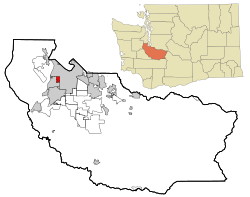
Fircrest is located at 47°13′54″N 122°30′51″W. The city shares its borders with Tacoma to the north and east. To the west and south, it borders University Place. Interestingly, a small part of Tacoma is completely surrounded by Fircrest. This is called an "enclave."
Size and Area of Fircrest
According to the United States Census Bureau, Fircrest covers a total area of about 1.58 square miles (4.10 square kilometers). All of this area is land, meaning there are no large lakes or rivers within the city limits.
People and Population of Fircrest
Fircrest has grown steadily over the years. Here's how the population has changed:
| Historical population | |||
|---|---|---|---|
| Census | Pop. | %± | |
| 1930 | 441 | — | |
| 1940 | 486 | 10.2% | |
| 1950 | 1,459 | 200.2% | |
| 1960 | 3,565 | 144.3% | |
| 1970 | 5,651 | 58.5% | |
| 1980 | 5,477 | −3.1% | |
| 1990 | 5,258 | −4.0% | |
| 2000 | 5,868 | 11.6% | |
| 2010 | 6,497 | 10.7% | |
| 2020 | 7,156 | 10.1% | |
| U.S. Decennial Census 2020 Census |
|||
A Look at the 2010 Population
In 2010, there were 6,497 people living in Fircrest. These people lived in 2,705 households, which are like homes or apartments. About 1,773 of these households were families. The average number of people living in each household was about 2.39.
The average age of people in Fircrest in 2010 was 41.2 years old. About 23.3% of the residents were under 18 years old. This means many young people and families call Fircrest home.
Education in Fircrest
Most students living in Fircrest attend schools within the Tacoma Public Schools district. However, a small part of the city is served by the University Place School District. This ensures that children in Fircrest have access to local public education.
See also
 In Spanish: Fircrest (Washington) para niños
 | Laphonza Butler |
 | Daisy Bates |
 | Elizabeth Piper Ensley |

