Fisher, Minnesota facts for kids
Quick facts for kids
Fisher, Minnesota
|
|
|---|---|

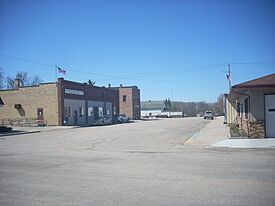
Downtown Fisher
|
|

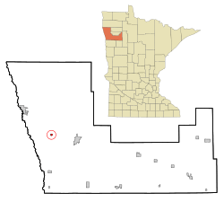
Location of Fisher in Polk County, Minnesota
|
|
| Country | United States |
| State | Minnesota |
| County | Polk |
| Metro | Greater Grand Forks |
| Founded | 1875 |
| Organized | 1876 |
| Incorporated | February 9, 1881 |
| Area | |
| • Total | 0.426 sq mi (1.103 km2) |
| • Land | 0.426 sq mi (1.103 km2) |
| • Water | 0.000 sq mi (0.000 km2) |
| Elevation | 853 ft (260 m) |
| Population
(2020)
|
|
| • Total | 422 |
| • Estimate
(2023)
|
404 |
| • Density | 948.45/sq mi (366.19/km2) |
| Time zone | UTC−6 (Central (CST)) |
| • Summer (DST) | UTC−5 (CDT) |
| ZIP Code |
56723
|
| Area code(s) | 218 |
| FIPS code | 27-21158 |
| GNIS feature ID | 2394767 |
| Sales tax | 7.375% |
Fisher is a small town in Polk County, Minnesota, United States. It's part of the larger Grand Forks area, which includes parts of both North Dakota and Minnesota. In 2020, about 422 people lived here. Fisher is often called a "bedroom community" because many people who live there work in the nearby Greater Grand Forks area.
Contents
History of Fisher
Fisher is one of the oldest towns in Polk County. It was first called "Shirt-Tail Bend." This unusual name came from a story about a shirt tied to a stick. This shirt was used to warn steamboats about a tricky bend in the river.
Later, the town was renamed 'Fisher's Landing,' and then simply 'Fisher.' These names honor William H. Fisher. He was born in New Jersey in 1844. William H. Fisher worked in the railroad business for many years. He helped manage and lead several railroad companies, including the St. Paul and Pacific railroad.
Geography of Fisher
Fisher is a small town when it comes to its size. According to the United States Census Bureau, the city covers about 0.426 square miles (1.103 square kilometers). All of this area is land, with no large bodies of water inside the city limits.
People of Fisher
| Historical population | |||
|---|---|---|---|
| Census | Pop. | %± | |
| 1880 | 239 | — | |
| 1890 | 481 | 101.3% | |
| 1900 | 410 | −14.8% | |
| 1910 | 328 | −20.0% | |
| 1920 | 305 | −7.0% | |
| 1930 | 297 | −2.6% | |
| 1940 | 333 | 12.1% | |
| 1950 | 302 | −9.3% | |
| 1960 | 326 | 7.9% | |
| 1970 | 383 | 17.5% | |
| 1980 | 453 | 18.3% | |
| 1990 | 395 | −12.8% | |
| 2000 | 435 | 10.1% | |
| 2010 | 435 | 0.0% | |
| 2020 | 422 | −3.0% | |
| 2023 (est.) | 404 | −7.1% | |
| U.S. Decennial Census 2020 Census |
|||
In 2022, there were about 159 homes in Fisher. On average, about 2.41 people lived in each home. The average yearly income for a household in Fisher was about $88,393.
Most people in Fisher have a good education. About 97.1% of adults have a high school diploma. Also, about 25.8% have a college degree or higher. About 71.7% of the people in Fisher have jobs.
The median age in Fisher was about 31.6 years old. This means half the people were younger than 31.6, and half were older.
Population in 2020
According to the 2020 United States census, 422 people lived in Fisher. There were 171 households and 99 families. Most of the people (91.00%) were White. About 4.50% of the population identified as Hispanic or Latino.
About 24.0% of the residents were under 18 years old. About 13.3% were 65 years old or older.
Population in 2010
In the 2010 United States census, there were 435 people living in Fisher. There were 180 households. About 35.6% of these homes had children under 18 living there.
The median age in 2010 was 32.2 years. About 25.7% of the people were under 18. The population was almost evenly split between males (50.3%) and females (49.7%).
See also
 In Spanish: Fisher (Minnesota) para niños
 | James B. Knighten |
 | Azellia White |
 | Willa Brown |

