Flaming Gorge-Uintas Scenic Byway facts for kids
Quick facts for kids
[[File:|x70px|alt= marker]] |
|
|---|---|
| Lua error in Module:Infobox_road/map at line 15: attempt to index field 'wikibase' (a nil value). | |
| Route information | |
| Maintained by UDOT | |
| Length | 79.558 mi (128.036 km) |
| Existed | 1988–present |
| Component highways |
|
| Major junctions | |
| South end | |
| North end | Wyoming state line SR-43 in Manila |
| Location | |
| Counties: | Uintah Daggett |
| Highway system | |
| State highways in Utah Interstate • US • State |
|
The Flaming Gorge - Uintas Scenic Byway is a special road in Utah. It's called a National Scenic Byway, which means it's recognized for its amazing views and interesting history. This road is about 80 miles (130 km) long. It takes you on a journey from Vernal, Utah up north. You'll drive through the beautiful Ashley National Forest and past the tall Uinta Mountains. The byway ends near the exciting Flaming Gorge National Recreation Area in the northeast part of Utah.
Contents
Exploring the Byway

This exciting road trip begins in Vernal, Utah. Vernal is a town in Uintah County. The byway starts where two main roads, US-40 and US-191, meet.
As you head north on US-191, you'll soon enter the Ashley National Forest. Along the way, you'll pass two cool places: Steinaker State Park and Red Fleet State Park. The road then starts to climb higher into the Uinta Mountains. It gets pretty steep in some places, with lots of turns called "switchbacks." These turns help cars climb up the mountain safely. The road reaches a high point of about 8,400 feet (2,600 m)!
After reaching the top, the road slowly starts to go downhill. You'll then enter Daggett County. Soon after, you'll arrive at the Flaming Gorge National Recreation Area. Right inside this area, the scenic byway splits into two different paths.
The Northeast Path (US-191)
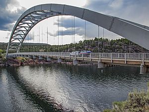
If you take the path to the right, you'll stay on US-191. This part of the road goes northeast. You'll drive over a part of Flaming Gorge Reservoir on a cool suspension bridge. Then, you'll cross the huge Flaming Gorge Dam. After that, you'll pass by the town of Dutch John.
The road then curves around the southwest side of Flaming Gorge Reservoir. It travels northwest through a spot called Dutch John Gap. Finally, it turns north through the gap and then northeast again. This path continues until it reaches the border of Wyoming.
The Northwest Path (SR-44)

If you choose the path to the left, you'll follow SR-44 heading west. This road runs along the southern edge of the recreation area. It roughly follows the southern rim of Flaming Gorge Reservoir. You'll pass a turnoff that leads to the Red Canyon Overlook and Visitors Center, which has amazing views!
As SR-44 gets closer to the western side of the recreation area, it starts to turn more to the north. The road goes down a series of turns as it approaches the southwest tip of Flaming Gorge Reservoir. It also passes through Sheep Creek Gap. From this point, the road turns north and leaves the recreation area. It continues for a few more miles before ending in the town of Manila, at the intersection with SR-43.
History of the Byway
The Flaming Gorge - Uintas Scenic Byway was first created in 1988. It was Utah's very first Forest Service Byway. This means it was recognized by the U.S. Forest Service for its special beauty and importance.
Later, on June 9, 1998, this byway became part of the National Scenic Byways system. This is a special list of roads across the United States that are known for their natural beauty, history, culture, or other unique features.
 | John T. Biggers |
 | Thomas Blackshear |
 | Mark Bradford |
 | Beverly Buchanan |

