Sagola Township, Michigan facts for kids
Quick facts for kids
Sagola Township, Michigan
|
|
|---|---|

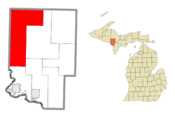
Location within Dickinson County
|
|
| Country | United States |
| State | Michigan |
| County | Dickinson |
| Established | 1887 |
| Area | |
| • Total | 162.75 sq mi (421.52 km2) |
| • Land | 159.71 sq mi (413.65 km2) |
| • Water | 3.04 sq mi (7.87 km2) |
| Elevation | 1,355 ft (413 m) |
| Population
(2020)
|
|
| • Total | 1,066 |
| • Density | 6.67/sq mi (2.58/km2) |
| Time zone | UTC-6 (Central (CST)) |
| • Summer (DST) | UTC-5 (CDT) |
| ZIP code(s) | |
| Area code(s) | 906 |
| FIPS code | 26-70600 |
| GNIS feature ID | 1627022 |
Sagola Township is a community located in Dickinson County, in the state of Michigan, USA. It's a type of local government area called a township. In 2020, about 1,066 people lived here.
Contents
Exploring Sagola Township's Geography
Sagola Township is a large area, and much of it is covered by the beautiful Copper Country State Forest. Several rivers flow through the township. The Michigamme River drains the northwest part. A small section in the northeast is drained by smaller streams that flow into the Escanaba River.
The central part of the township is drained by the Ford River. The southern area is drained by the Sturgeon River.
How Big is Sagola Township?
The United States Census Bureau tells us the total area of the township. It covers about 162.8 square miles (421.5 square kilometers). Most of this area, about 160.3 square miles (415.2 square kilometers), is land. The rest, about 2.5 square miles (6.5 square kilometers), is water.
Communities in Sagola Township
Sagola Township does not have any big cities or towns with their own governments. Instead, it has a few smaller, unincorporated communities. These are places where people live, but they are not officially separate towns.
- Channing is located on M-95. It's about 24 miles (39 km) north of Iron Mountain. This community started as a railroad stop called "Ford Siding." In 1892, a post office opened and was named Channing. It was named after John Parke Channing, a mining engineer who studied the area. The Channing post office still serves the ZIP code 49815 today.
- Floodwood is also on M-95, about five miles (8 km) north of Channing. It's close to the border of Marquette County. Floodwood began as a place where lumber was harvested. It was on the Milwaukee and Northern Railroad. There was a post office here from 1887 until 1905.
- Randville is found on M-95, about 14 miles (23 km) north of Iron Mountain. It's just south of where M-95 meets M-69. This community grew because of the nearby Groveland Mine. Randville was a train station on the Milwaukee and Northern Railroad in 1880. It had a post office from 1891 until 1932.
- Sagola is located right on M-95, where M-69 splits off to the west. Crystal Falls is about 13 miles (21 km) west on M-69. The M-69 highway runs along with M-95 for about six miles (10 km) south of Sagola. Sagola was formed around 1885 when five men from Chicago started the Sagola Lumber Company. They wanted to cut down pine trees in the area. The name "Sagola" comes from a local Native American word meaning "welcome." The first post office in Sagola opened in 1889, and it still serves the ZIP code 49881.
Population of Sagola Township
In the year 2000, a census showed that 1,169 people lived in Sagola Township. There were 475 households and 323 families. By the year 2020, the population had changed slightly to 1,066 people.
See also
 In Spanish: Municipio de Sagola para niños


