
Republic, Michigan facts for kids
Quick facts for kids
Republic, Michigan
|
|
|---|---|

Location within Marquette County
|
|

Republic, Michigan
Location in Michigan

Republic, Michigan
Location in the United States
|
|
| Country | United States |
| State | Michigan |
| County | Marquette |
| Townships | Republic and Humboldt |
| Area | |
| • Total | 3.94 sq mi (10.21 km2) |
| • Land | 3.62 sq mi (9.37 km2) |
| • Water | 0.33 sq mi (0.85 km2) |
| Elevation | 1,522 ft (464 m) |
| Population
(2020)
|
|
| • Total | 470 |
| • Density | 129.91/sq mi (50.16/km2) |
| Time zone | UTC-5 (Eastern (EST)) |
| • Summer (DST) | UTC-4 (EDT) |
| ZIP Code |
49879
|
| Area code(s) | 906 |
| FIPS code | 26-67980 |
| GNIS feature ID | 634306 |
Republic is a small community in Marquette County, which is part of the U.S. state of Michigan. It is known as an "unincorporated community." This means it doesn't have its own local government like a city or town.
For counting purposes, Republic is also a census-designated place (CDP). This helps the government collect information about the population. In 2020, about 470 people lived there. Most of Republic is located in Republic Township. A small part of it extends north into Humboldt Township.
The ZIP Code for Republic is 49879. This ZIP Code covers a much larger area than just the community itself. It includes most of Republic Township and parts of other nearby townships.
Contents
History of Republic
The community of Republic got its name from the Republic Iron Company. A post office has been open in Republic since 1873.
From 1980 to 2004, the U.S. Navy had a special site near Republic. This site was part of something called Project ELF. ELF stands for "extremely low frequency." It was used to send messages to submarines deep underwater.
Where is Republic Located?
Republic is in the western part of Marquette County. It is about 20 miles southwest of Ishpeming. It is also about 34 miles west-southwest of Marquette, which is the main city of the county.
Most of the Republic CDP is within Republic Township. A very small part, with only a few residents, is in Humboldt Township.
The Michigamme River forms most of the eastern edge of the community. State Highway M-95 runs along the entire western edge. M-95 goes north to connect with other major highways. It also goes south to Iron Mountain.
The Republic CDP covers a total area of about 3.94 square miles. Most of this area, about 3.62 square miles, is land. The rest, about 0.33 square miles, is water.
People in Republic
The number of people living in Republic has changed over the years.
| Historical population | |||
|---|---|---|---|
| Census | Pop. | %± | |
| 2000 | 614 | — | |
| 2010 | 570 | −7.2% | |
| 2020 | 470 | −17.5% | |
| U.S. Decennial Census | |||
In 2000, there were 614 people living in Republic. Most of the people were White (98.05%). A small number were Native American (1.63%) or from two or more racial backgrounds (0.33%).
There were 276 households in 2000. A household is a group of people living together. About 26.4% of these households had children under 18. Many households were married couples living together. Some people lived alone, especially those aged 65 or older.
The average age of people in Republic in 2000 was 45 years old.
Education in Republic
Students in Republic attend schools operated by the Republic-Michigamme School District. This district includes the Republic-Michigamme High School.
Images for kids
-
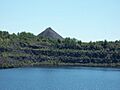
Remains of the Republic Mine in Republic, now filled with water.

See also
 In Spanish: Republic (Míchigan) para niños
