Fort Benson facts for kids
Quick facts for kids Fort Benson |
|
|---|---|

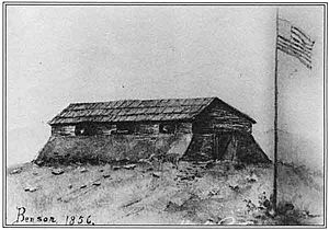
Fort Benson in 1856
|
|
| Location | 2194 E Oliver Holmes Rd, Colton, California |
| Built | 1856 |
| Architect | US Army |
| Designated | September 11, 1957 |
| Reference no. | 617 |
| Lua error in Module:Location_map at line 420: attempt to index field 'wikibase' (a nil value). | |
Fort Benson was a small fort built in 1856 in what is now Colton, California. It was located in San Bernardino County, California. The fort was named after its builder, Jerome Benson. He built it because he was worried about land arguments. The fort was made of earth and wood. It was even defended by a brass cannon!
Fort Benson was only used for about a year. Many Mormons living near Benson's land were asked to return to Utah during a conflict called the Utah War. The fort was abandoned in 1857. Today, Fort Benson is gone, but a special marker shows where it once stood. On September 11, 1957, Fort Benson was recognized as a California Historical Landmark (No. 617).
In December 1858, the US Army came to San Bernardino. Colonel William Hoffman led the Mojave Expedition. He placed soldiers in San Bernardino and Cajon Pass to help with issues involving Native Americans and land.
The Utah War
The Utah War was a conflict that happened between 1857 and 1858. It was a disagreement between Mormon settlers in the Utah Territory and the United States government.
The conflict lasted from May 1857 to July 1858. There were some injuries and deaths, mostly among non-Mormon civilians. However, there were no big military battles.
In 1857, President James Buchanan sent US forces to the Utah Territory. This was known as the Utah Expedition. The Mormons were afraid that this large army was sent to destroy them. They had faced unfair treatment in other places before. So, they got ready to defend themselves. They fixed firearms and even turned farm tools into weapons.
Both sides hoped to avoid bloodshed, but they also prepared for war. In the end, the United States and the Latter-day Saints talked things out. The Mormons received a full pardon. The governor of Utah changed from church President Brigham Young to a non-Mormon named Alfred Cumming. The US Army then entered Utah peacefully.
Jedediah Smith's Visit
Long before Fort Benson was built, a famous explorer named Jedediah Smith camped at this very spot. This happened in January 1827. He was on his first trip to California. Smith had just left San Diego after meeting the Mexican Governor. He was told to leave California and was heading towards the Central Valley.
Jumuba Native American Village
The area where Fort Benson was built was also home to the Jumuba Native American people. The Jumuba lived in three groups of huts. These huts were near fresh water springs. This spot is close to Hunts Lane today, just south of Interstate 10.
The first written record of the Jumuba people came from a Spanish missionary named José Bernardo Sánchez. In September 1821, he found the tribe living in huts and taking care of cattle. This place was called the Jumuba rancheria. A rancheria is a small Native American settlement. The Jumuba rancheria was a few miles west of the Guachama Mission Station. This station was also known as Guachama Rancheria. It was built in 1810 in what is now Bunker Hill, Politana, California.
Historical Markers
There are several markers in the area that tell us about the history of this important spot.
- The main marker at the Fort Benson site reads:
* NO. 617 FORT BENSON – This is the site of an adobe fortification erected about 1856–57 by the 'Independent' faction in a dispute with the Mormons over a land title. The fort was maintained for about a year. This also is the site of the Indian village of Jumuba, and Jedediah Smith camped here in January 1827. * This marker was put up in 1935 by Lugonia Parlor No. 241, N.D.G.W and Arrowhead Parlor No. 110, N.S.G.W. (Marker Number 617.)
- North of the Fort, there is another marker about Jedediah Smith. It is called "Pathfinder of the Southern Sierras" and reads:
* Born at Brambridge in Northern N.Y. January 6, 1799 he discovered south pass of the Rocky Mts. the great gateway through which passed nearly all subsequent migration west and northwest from the Atlantic to the Pacific. He was the first American to enter California by the overland route through Cajon Pass in November 1826. Jedediah Smith stands peerless among the pathfinders of California's epic past. * This marker was put up in 1951 by Lugonia Parlor 241 Native Daughters of Golden West.
- To the south, there is a marker for the nearby Guachama Rancheria. It reads:
* Guachama Rancheria, lying along this road, was named San Bernardino May 20, 1810, by Francisco Dumetz. In 1819 it became the San Bernardino Rancho of Mission San Gabriel. The adobe administration building stood about 70 yds. north of this spot, an enramada serving as chapel. The Zanja was constructed to convey water from the mountains for irrigation. Control by mission fathers ended in 1834. * This marker was put up in 1932 by Arrowhead Chapter Daughters of the American Revolution. (Marker Number 95.)

