Fort Dick, California facts for kids
Quick facts for kids
Fort Dick, California
|
|
|---|---|

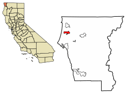
Location of Fort Dick in Del Norte County, California.
|
|
| Country | United States |
| State | California |
| County | Del Norte |
| Elevation | 52 ft (16 m) |
| Population
(2020)
|
|
| • Total | 912 |
| Time zone | UTC-8 (Pacific (PST)) |
| • Summer (DST) | UTC-7 (PDT) |
| ZIP codes |
95538 (homes - 95531)
|
| Area code(s) | 707 |
| GNIS feature ID | 223696 |
Fort Dick (Tolowa: Mvn-des-chuu-dvn) is a small community in Del Norte County, California. It is not a city, but an "unincorporated community." This means it does not have its own local government. It is also a "census-designated place" (CDP), which is an area the government defines for counting people.
Fort Dick is about five miles (eight kilometers) north of Crescent City, California. It is also about 15 miles (24 kilometers) south of the California–Oregon state line. In 2020, 912 people lived there, which was more than the 588 people in 2010. The community is located along U.S. Route 101, a major highway, on the beautiful Redwood Coast. A post office was first opened in Fort Dick in 1917.
Contents
What's in a Name?
The name "Fort Dick Landing" goes back to the time of the American Civil War. It was named after a log house that settlers built. This house was called a "fort" and was used for protection.
In 1888, a mill that made wooden shakes and shingles moved to the area. The Bertsch brothers, who owned the mill, renamed the place "Newburg." However, when a post office was set up in 1896, the original name, Fort Dick, was brought back.
A Look at Fort Dick's Past
Early Native American Life
The thick forests around Fort Dick were once home to the Tolowa and Yurok tribes. These Native American groups lived on and used this land for many years.
Jedediah Smith's Journey (1828)
Historical records show that Jedediah Smith and his group explored the Fort Dick area. They traveled along the eastern side of Lake Earl from June 14 to 16, 1828. During this time, they met and traded with the Tolowa people. This visit happened about 25 to 30 years before the land became known as "Russell's Prairie" or Fort Dick.
On June 14, the group camped near Elk Creek. They had to walk through the ocean at times, with waves as high as their horses. The next day, Tolowa people brought them fish, clams, and berries to trade. On June 16, the group moved north. They had some trouble getting their horses across Elk Creek. They camped south of Lake Earl and explored its eastern edge.
About a month later, on July 14, 1828, Jedediah's group was attacked. Most of his party died in the ambush. Jedediah and two others escaped and went to Fort Vancouver.
Dangerous Waters: Shipwrecks Near Fort Dick
The ocean waters near Crescent City and Fort Dick are known for being very dangerous. Many ships have sunk in this area over the years.
- In 1850, the ship Paragon sank.
- In 1851, the Tarquin was lost.
- In 1855, the Steamer America caught fire in Crescent City harbor.
- In 1865, the Steamer Brother Jonathan hit a hidden reef.
- In 1941, the SS Emidio, an oil tanker, was attacked by a Japanese submarine. This was the first American ship sunk by Japan off the Pacific coast during World War II.
The Fort Dick Road (1862)
During the Civil War, there were several roads leading to Crescent City. A letter from 1862 mentions a "Fort Dicks Road" as a good path for travel. Other roads were risky when rivers were high.
The Fort Dick Road started at Camp Lincoln. Camp Lincoln was important because it was where two main pioneer roads met. One road, Fort Dick Road, went up the coast. The other, Crescent City Plank Road, went inland to mining towns in Southern Oregon.
Even in 1948, maps still showed parts of the old Fort Dick Road. This road followed high ground and crossed Younkers Creek. It then connected to what are now Lower Lake Road, Sarina Road, and Oceanview Drive.
When the Roosevelt Highway was built in the 1920s, the original Fort Dick settlement moved. It moved from the west end of Moorehead Road to the east end. This way, the community stayed on the main route north.
Fort Dick During the Civil War
The area of Fort Dick was used by Native American tribes for a long time. When white settlers arrived, there were conflicts with tribes like the Tolowa. These groups often had small battles with the new settlers.
Because of this ongoing unrest, the military was called in. In 1862, the Department of Indian Affairs asked for a military presence. The goal was to keep peace between settlers in Crescent City and Native Americans on a nearby reservation.
However, the military chose a different spot for their camp. They picked a place now known as Camp Lincoln. Camp Lincoln is about 3.5 miles (5 kilometers) south of Fort Dick. It is also about six miles north of Crescent City. The first buildings at Camp Lincoln were still standing in the 1950s and 1960s.
Native American Land Claims
Today, the Tolowa and Yurok Nations are the closest Native American groups to Fort Dick. In 1855, the U.S. government forced many Yurok people onto a reservation. They were moved several times. After a flood in 1862, the Yurok moved to the Smith River Reservation. But this reservation closed in 1867.
At that time, several coastal tribes, including the Tolowa and Yurok, moved to the Hoopa Valley Reservation. Today, the Tolowa are the only tribe with their main ceremonial center in Fort Dick. However, the Yurok Nation's website shows that their traditional lands covered a very large area. This area included many cities along the California coast.
Fort Dick's Weather
Fort Dick has mild and dry summers. The average monthly temperature never goes above 71.6°F (22°C). This type of weather is called a "warm-summer Mediterranean climate." It means the area has warm, dry summers and mild, wet winters.
| Climate data for Fort Dick, California 141ft(43m) (1981-2010) | |||||||||||||
|---|---|---|---|---|---|---|---|---|---|---|---|---|---|
| Month | Jan | Feb | Mar | Apr | May | Jun | Jul | Aug | Sep | Oct | Nov | Dec | Year |
| Mean daily maximum °F (°C) | 53.7 (12.1) |
55.4 (13.0) |
56.5 (13.6) |
58.4 (14.7) |
61.4 (16.3) |
63.8 (17.7) |
65.8 (18.8) |
66.2 (19.0) |
66.2 (19.0) |
63.4 (17.4) |
57.1 (13.9) |
53.3 (11.8) |
60.1 (15.6) |
| Daily mean °F (°C) | 47.5 (8.6) |
48.7 (9.3) |
49.3 (9.6) |
50.9 (10.5) |
53.9 (12.2) |
58.4 (14.7) |
58.6 (14.8) |
59.0 (15.0) |
57.9 (14.4) |
55.2 (12.9) |
50.7 (10.4) |
47.2 (8.4) |
53.1 (11.7) |
| Mean daily minimum °F (°C) | 41.2 (5.1) |
41.9 (5.5) |
42.2 (5.7) |
43.4 (6.3) |
46.3 (7.9) |
49.0 (9.4) |
51.4 (10.8) |
51.9 (11.1) |
49.7 (9.8) |
47.0 (8.3) |
44.2 (6.8) |
41.1 (5.1) |
45.8 (7.7) |
| Average precipitation inches (mm) | 11.84 (301) |
9.59 (244) |
10.44 (265) |
7.04 (179) |
3.71 (94) |
2.03 (52) |
0.35 (8.9) |
0.56 (14) |
1.35 (34) |
5.16 (131) |
10.23 (260) |
14.16 (360) |
76.46 (1,942.9) |
| Average relative humidity (%) | 78.7 | 77.0 | 78.8 | 78.3 | 78.3 | 78.0 | 81.9 | 82.3 | 77.2 | 76.1 | 79.5 | 78.6 | 78.7 |
| Average dew point °F (°C) | 41.2 (5.1) |
41.8 (5.4) |
43.0 (6.1) |
44.4 (6.9) |
47.3 (8.5) |
50.3 (10.2) |
53.1 (11.7) |
53.6 (12.0) |
50.8 (10.4) |
47.8 (8.8) |
44.6 (7.0) |
40.9 (4.9) |
46.6 (8.1) |
Population Changes Over Time
The population of Fort Dick has changed over the years. Here is a look at how many people have lived there during different census counts:
| Historical population | |||
|---|---|---|---|
| Census | Pop. | %± | |
| U.S. Decennial Census | |||
 | Aurelia Browder |
 | Nannie Helen Burroughs |
 | Michelle Alexander |


