Fort Rock facts for kids
Quick facts for kids Fort Rock |
|
|---|---|

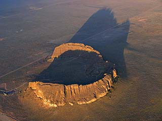
Aerial view of Fort Rock from the northeast.
|
|
| Highest point | |
| Elevation | 4,699 ft (1,432 m) NAVD 88 |
| Prominence | 345 ft (105 m) |
| Geography | |
| Location | Lake County, Oregon, U.S. |
| Parent range | Basin and Range |
| Geology | |
| Age of rock | 50,000 to 100,000 years |
| Mountain type | Tuff ring |
| Climbing | |
| Easiest route | Trail |
| Designated: | 1976 |
Fort Rock is an amazing natural landmark in Oregon, United States. It's a special kind of volcano shape called a tuff ring. This ring sits on what used to be a huge lake bed during the Ice Age.
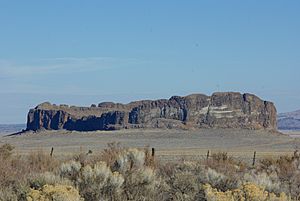
The Fort Rock ring is really big, about 4,460 feet (1,360 meters) wide. It stands about 200 feet (61 meters) tall above the flat land around it. Its name comes from its tall, straight sides, which look like the strong walls of a fort. The area around Fort Rock has about 40 similar volcano shapes. An early settler named William Sullivan discovered Fort Rock in 1873 while looking for his lost cattle.
Contents
How Fort Rock Was Formed
Fort Rock was created when hot, melted rock, called basalt magma, rose to the surface. This magma met the wet mud at the bottom of a large lake. When the hot magma hit the water, it caused huge steam explosions!
These explosions blew molten basalt into the air, creating a fountain of hot lava pieces and frothy ash. These hot pieces rained down around the volcano's opening. They formed a saucer-shaped ring of tuff and volcanic ash that looked like an island in the lake.
The lake's waves slowly wore away the outside of the ring. This erosion created steep cliffs and terraces about 66 feet (20 meters) above the valley floor. The strong winds from the south, which still blow today, pushed waves against the south side of the ring. This caused a large opening to form on that side.
How Old Is Fort Rock?
Scientists believe Fort Rock is between 50,000 and 100,000 years old. This was a time when large lakes filled many valleys in central Oregon and other parts of the western United States.
At its biggest, the lake around Fort Rock was huge. It covered almost 900 square miles (2,300 square kilometers). The water was about 150 feet (46 meters) deep where Fort Rock formed.
A large terrace on the side of Fort Rock shows where the lake's edge was about 14,000 years ago. Even higher water levels are seen on the cliffs. At one point, only the very tops of the tuff ring stuck out of the water like rocky islands. The highest lake level happened about 21,000 years ago.
Fort Rock State Natural Area
Today, Fort Rock is a protected area called the Fort Rock State Natural Area. It's a great place to visit and learn about geology.
Other Cool Nearby Places
There are many other interesting geological spots near Fort Rock:
- Fort Rock Cave: This cave was formed by water in another nearby tuff ring. In 1938, scientists found ancient sagebrush sandals and human tools here. These items are about 9,000 to 10,000 years old!
- Hole-in-the-Ground and Big Hole: These are two large holes, almost a mile wide, formed by steam explosions. They look like craters made by meteorites, but they don't have the special metals found in space rocks.
- Crack in the Ground: This is a long, deep crack in the earth.
- Fossil Lake: This area has many fossils from the Ice Age.
- South Ice Cave: This is a lava tube, which is like a tunnel formed by flowing lava.
- Derrick Cave: This lava tube is estimated to be 1,200 feet (366 meters) long.
- Devil's Garden Lava Field and East Lava Field: These areas have strange lava formations, including inflated lava, and different types of lava flows like ʻaʻā and pāhoehoe.
The small community of Fort Rock and the Fort Rock Valley Historical Homestead Museum are located about one mile south of the Fort Rock State Natural Area.
See also
 In Spanish: Fort Rock para niños
 | George Robert Carruthers |
 | Patricia Bath |
 | Jan Ernst Matzeliger |
 | Alexander Miles |


