
Fort Sumner, New Mexico facts for kids
Quick facts for kids
Fort Sumner, New Mexico
|
|
|---|---|
|
Village
|
|

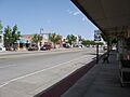
Downtown Fort Sumner in 2003
|
|

Location of Fort Sumner, New Mexico
|
|

Fort Sumner, New Mexico
Location in the United States
|
|
| Country | United States |
| State | New Mexico |
| County | De Baca |
| Area | |
| • Total | 3.35 sq mi (8.66 km2) |
| • Land | 3.31 sq mi (8.58 km2) |
| • Water | 0.03 sq mi (0.08 km2) |
| Elevation | 4,045 ft (1,233 m) |
| Population
(2020)
|
|
| • Total | 889 |
| • Estimate
(2023)
|
863 |
| • Density | 268.17/sq mi (103.56/km2) |
| Time zone | UTC−7 (Mountain (MST)) |
| • Summer (DST) | UTC−6 (MDT) |
| ZIP code |
88119
|
| Area code(s) | 575 |
| FIPS code | 35-27340 |
| GNIS feature ID | 2413553 |
Fort Sumner is a small village in De Baca County, New Mexico, in the United States. It is also the main town, or county seat, of De Baca County. In 2020, about 889 people lived there. Fort Sumner is also known as a key location for the Columbia Scientific Balloon Facility, which launches large scientific balloons.
Contents
History of Fort Sumner
Early Days and the Military Fort
Fort Sumner got its name from Edwin Vose Sumner, who was a military governor of the New Mexico Territory. The military fort was built in 1862. From 1863 to 1868, it was used to house Navajo and Mescalero Apache people.
In 1868, the government closed the fort. Its buildings were sold to Lucien Maxwell, a rich landowner in New Mexico. Years later, Maxwell's son, Pete, became friends with the famous outlaw Billy the Kid. Billy the Kid was later killed in Pete Maxwell's house by Pat Garrett. Both Billy the Kid and Lucien Maxwell are buried in the old military cemetery in Fort Sumner.
Cattle Trails and Railways
In 1866, the U.S. government needed food for the many Native American people living at Fort Sumner. Two businessmen, Charles Goodnight and Oliver Loving, saw a chance to help. They decided to sell beef to the government. This led to the creation of the famous Goodnight-Loving Trail, which was used to move cattle.
In March 1908, a railway line called the Eastern Railway of New Mexico reached Fort Sumner. This was part of a larger railway system, the Atchison, Topeka and Santa Fe Railway. The railway helped the village grow and connect with other places.
Airfield and Space Science
In the 1920s, an airline called Transcontinental Air Transport built an airfield in Fort Sumner. This was part of their plan for air travel across the country. However, their plans stopped during the Great Depression.
The airfield was used again during World War II by the United States Army Air Forces for training. After the war, it became the Fort Sumner Municipal Airport. Today, it is an important place for NASA's high-altitude balloon program, where large balloons are launched for scientific research. This is why the Columbia Scientific Balloon Facility is located here.
Geography and Climate
Where is Fort Sumner?
Fort Sumner is located in the northeastern part of De Baca County. It sits on the north side of the Pecos River.
Two main roads pass through the village. U.S. Route 60 goes through Fort Sumner as Sumner Avenue. It connects the village to Clovis to the east and Vaughn to the west. U.S. Route 84 comes from the north as 4th Street, leading to Santa Rosa. US 84 also runs east with US 60 towards Clovis.
Weather in Fort Sumner
Fort Sumner has a climate with warm summers and mild winters. The village gets some rain, especially in the summer months. It also sees a small amount of snow during winter.
| Climate data for Fort Sumner, New Mexico (1981–2010) | |||||||||||||
|---|---|---|---|---|---|---|---|---|---|---|---|---|---|
| Month | Jan | Feb | Mar | Apr | May | Jun | Jul | Aug | Sep | Oct | Nov | Dec | Year |
| Mean daily maximum °F (°C) | 56.3 (13.5) |
60.8 (16.0) |
68.5 (20.3) |
77.5 (25.3) |
85.7 (29.8) |
95.3 (35.2) |
94.4 (34.7) |
92.4 (33.6) |
86.4 (30.2) |
76.1 (24.5) |
64.6 (18.1) |
55.7 (13.2) |
76.1 (24.5) |
| Mean daily minimum °F (°C) | 22.3 (−5.4) |
26.2 (−3.2) |
33.7 (0.9) |
39.7 (4.3) |
50.7 (10.4) |
60.5 (15.8) |
64.3 (17.9) |
62.9 (17.2) |
55.3 (12.9) |
42.7 (5.9) |
29.1 (−1.6) |
23.0 (−5.0) |
42.5 (5.8) |
| Average precipitation inches (mm) | 0.42 (11) |
0.41 (10) |
0.70 (18) |
0.86 (22) |
1.30 (33) |
1.60 (41) |
2.18 (55) |
3.22 (82) |
1.74 (44) |
1.57 (40) |
0.66 (17) |
0.60 (15) |
15.25 (387) |
| Average snowfall inches (cm) | 4.1 (10) |
2.9 (7.4) |
1.0 (2.5) |
0.5 (1.3) |
0.0 (0.0) |
0.0 (0.0) |
0.0 (0.0) |
0.0 (0.0) |
0.0 (0.0) |
0.1 (0.25) |
1.5 (3.8) |
4.9 (12) |
15.0 (38) |
| Source: NOAA | |||||||||||||
People of Fort Sumner
Population Changes Over Time
The number of people living in Fort Sumner has changed over the years.
| Historical population | |||
|---|---|---|---|
| Census | Pop. | %± | |
| 1920 | 777 | — | |
| 1930 | 839 | 8.0% | |
| 1940 | 1,669 | 98.9% | |
| 1950 | 1,982 | 18.8% | |
| 1960 | 1,809 | −8.7% | |
| 1970 | 1,615 | −10.7% | |
| 1980 | 1,421 | −12.0% | |
| 1990 | 1,269 | −10.7% | |
| 2000 | 1,249 | −1.6% | |
| 2010 | 1,031 | −17.5% | |
| 2020 | 889 | −13.8% | |
| U.S. Decennial Census | |||
In 2000, there were 1,249 people living in Fort Sumner. About half of the people identified as Hispanic or Latino. The village had many different types of families and households.
Education
The schools in Fort Sumner are part of the Fort Sumner Municipal Schools district. This district serves all of De Baca County.
Images for kids
-
A view along U.S. Route 84 in Fort Sumner

See also
 In Spanish: Fort Sumner para niños
