Fort Valley (Virginia) facts for kids
Quick facts for kids Fort Valley |
|
|---|---|

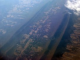
Air photo of Fort Valley, facing south, with the North (right) and South (left) Forks of the Shenandoah River visible. February 2009.
|
|
| Length | 23 miles (37 km) North to south |
| Geography | |
| Location | Shenandoah County, Virginia |
| Borders on | Massanutten Mountain (all sides) |
| Traversed by | S.R. 678 |
Fort Valley is a special mountain valley mostly found in Shenandoah County, Virginia. People often call it a "valley within a valley." This is because it sits right between two parts of the Blue Ridge Mountains. It's part of the bigger Shenandoah Valley in the Ridge-and-Valley Appalachians area.
The eastern side of Fort Valley is called Massanutten Mountain. The western side has mountains like Three Top Mountain, Powell Mountain, and Short Mountain. There's also Green Mountain, which is even taller. Two high points in the valley are Duncan's Knob (2,800 feet) and Strickler's Knob (over 2,700 feet).
Fort Valley is almost completely surrounded by mountains. At its south end, you can enter through Moreland Gap. In the north, it's very narrow, with Passage Creek flowing out towards Front Royal. Passage Creek runs through the middle of the valley from south to north. It gets water from other streams along the way. The valley is about 3 miles wide at its widest point. The very southern tip of the valley is in Page County. The rest of Fort Valley is in Shenandoah County. The valley is about 23 miles long in total.
Fort Valley is a quiet, rural area. Most of it is private farmland. It's surrounded by the George Washington National Forest (GWNF). This forest covers the mountain slopes and offers many fun outdoor activities. About 1,259 people live here, and the valley covers about 70 square miles. The Elizabeth Furnace and Camp Roosevelt Recreation Area of the GWNF are both located inside Fort Valley.
Contents
How Fort Valley Was Formed (Geology)
The mountains and valleys here, including Fort Valley and the Massanutten range, were formed by a huge geological event. This event is called the Alleghanian orogeny. It's when Earth's plates push together, making the land crumple and rise into mountains. Fort Valley is like a big, downward fold in the Massanutten range.
Over millions of years, the softer rocks in the valley wore away. These rocks were mostly limestone and a mix called flysch. The harder rocks, like the tough quartz sandstone of the Massanutten mountains, resisted erosion. This is why you see mountains and valleys in this area. The floor of Fort Valley is mostly limestone. Passage Creek, though small now, was once a much larger river. It helped carve out the valley we see today.
Hiking Trails and Fun Places
Fort Valley is a great place for outdoor adventures, especially hiking and camping.
Long Hiking Trails
The Tuscarora Trail is a long hiking path, 252 miles in total. It goes through Virginia, West Virginia, Maryland, and Pennsylvania. Part of this trail runs along the northeast side of Fort Valley. It passes through the Elizabeth Furnace Recreation Area. It then goes up Green Mountain and leaves the valley near Tom's Brook.
The Massanutten Trail is a 71-mile loop that goes all the way around Fort Valley. The Potomac Appalachian Trail Club finished building it in 2001. Before that, different parts of the trail had different names. Now, the whole loop is called the Massanutten Trail and has orange markers.
Woodstock Tower
The Woodstock Tower was built in 1935 by the Civilian Conservation Corps. It sits on Powell Mountain, about 2,000 feet above the town of Woodstock. You can reach the tower by driving on State Route 758, a gravel road with winding turns. You can also hike to it on the Massanutten Trail. The tower is a popular spot because it offers amazing views. You can see the Shenandoah Valley and the winding Shenandoah River to the west. To the east, you can see other Massanutten ridges and Page Valley.
Forest Service Recreation Areas
Fort Valley has two main recreation areas run by the U.S. Forest Service. These are the Elizabeth Furnace Recreation Area and the Camp Roosevelt Recreation Area. Both were built in the 1930s by the Civilian Conservation Corps.
- Camp Roosevelt is in the southeast part of the valley. It has a place for hang gliding nearby, a picnic shelter, and campsites. You can also get on the Massanutten Trail from here.
- Elizabeth Furnace is in the northern part of the valley. It has a picnic shelter and many camping spots. You can learn about the old iron industry that used to be there. Both the Massanutten and Tuscarora trails can be accessed from Elizabeth Furnace.
Swimming Holes and Other Camping Spots
Near Elizabeth Furnace, there are two popular swimming spots in Passage Creek. They are called Blue Hole and Buzzards Rock Hole (or Red Hole). These are natural areas, so swimming there is at your own risk.
The Little Fort Recreation Area has 10 campsites. It's located off Route 758, near Woodstock Tower. Campers often use this area to access Peter's Mill Run Road. This road is used for ATVs and 4-wheel drive vehicles.
Crisman's Hollow Road (Forest Road 274) is in the southern part of Fort Valley in Page County. It's a popular spot for camping right by the road in the George Washington National Forest. You can also find trails here that lead to several mountains and the Massanutten Trail.
Special Nature Areas
The U.S. Forest Service manages several Special Biological Areas (SBAs) on the ridges of Fort Valley. These are places with unique plants and animals. They include:
- Mudhole Gap SBA
- Peters Mill Run Bog SBA
- Signal Knob SBA
- Edinburg Gap Shale Barrens SBA
- Scothorn Gap SBA
Waterfall Mountain Cliffs, at the very southern end of the Massanutten Mountain ridgeline, is also important. It has been suggested to become a Special Biological Area because of its untouched natural beauty.
History of Fort Valley
Fort Valley was once a hunting ground for Native Americans. The name Massanutten is thought to mean "Indian Basket." This might be because the valley is shaped like a basket and used to be full of wild game. While no permanent Native American villages were here, tools and other items have been found. In the 1740s, Massanutten Mountain was called Peaked Mountain, and later Buffalo Mountain. George Washington surveyed Fort Valley for Lord Fairfax in 1748.
Early Settlers
Before Washington's survey, a man named Powell, who was said to be running from the law, hid in the valley. This area became known as Powell's Fort Mountain or Powell's Fort Valley, and later just "The Fort." Powell's Mountain is named after him. Around 1733, a few hunters settled in "The Fort," and more people soon followed.
Revolutionary War Connection
Legend says that Daniel Morgan built the first road into Fort Valley. He did this on the orders of George Washington. Washington thought Fort Valley could be a safe place for the Continental Army to hide if they were losing the American Revolution. Washington had surveyed the valley before and knew it was naturally protected by mountains. After a very hard winter at Valley Forge, Washington said that if the war didn't go well, he would move the army south to the Shenandoah and make a stand in "The Fort." Morgan supposedly started building a road, but the work stopped when the army began winning. This route became known as Morgan's Road. Parts of it can still be seen today as a hiking trail. The Continental Army's victory at Yorktown meant Washington's plans were not needed.
The Daniel Munch House is a historic home and farm built in 1834. It overlooks Passage Creek in Fort Valley. It was added to the National Register of Historic Places in 2002. Daniel Munch was a successful farmer and distiller. His family were early German settlers who moved to Fort Valley in 1779. The house shows great examples of German-style architecture. It was the only brick house in Fort Valley as late as 1937.
Iron Industry
Fort Valley had a busy iron industry in its early days. This was because it had lots of iron ore, limestone (needed for iron-making), and timber for fuel. Blast furnaces used charcoal to melt the iron ore. The melted iron was then shaped into "pigs" and hammered into bars.
Elizabeth Furnace was a very important blast furnace. It made iron from 1836 to 1888. It used Passage Creek for water power. The iron was taken over Massanutten Mountain to the Shenandoah River. From there, it went to other places for shaping. The road used to transport the iron is now a hiking trail. Elizabeth Furnace had a whole community living around it. Union troops destroyed it in October 1864 during the Battle of Cedar Creek. The furnace reopened in 1883 but closed for good in 1888. The Elizabeth Furnace Cabin is one of the few old wooden buildings left from that time. In 1936, the Civilian Conservation Corps built the Elizabeth Furnace Recreation Area on the site.
Further south in Fort Valley, another iron furnace called Caroline Furnace was built around 1835. It had 35 buildings and about 120 workers. It made iron for railroads. During the Civil War, both Elizabeth and Caroline furnaces made iron for the Confederacy. This iron was sent to Richmond. Union troops also destroyed Caroline Furnace in 1864. This was part of Sheridan's campaign to destroy anything useful to the Confederacy. Unlike Elizabeth Furnace, Caroline Furnace was never rebuilt. Today, the old site of Caroline Furnace is a Lutheran camp.
Civil War Signal Post
Signal Knob is a high point (2,111 feet) at the very northern end of Fort Valley. It offers wide views of the Shenandoah Valley. During the Civil War, it was an important observation and signal post for the Confederate army. Some Confederate soldiers died fighting for control of Signal Knob. One is still buried there, and his grave inspired a poem called "The Georgia Volunteer." From Signal Knob, you can see the areas where battles like Cedar Creek, Fisher's Hill, and Tom's Brook took place. You can reach Signal Knob by an 11.5-mile round-trip hike from Elizabeth Furnace. No major battles were fought inside Fort Valley itself. However, Confederate cavalry led by General John Imboden sometimes camped there.


