
Four Peaks facts for kids
Quick facts for kids Browns Peak |
|
|---|---|
| Yavapai: Wikopa | |

View of Four Peaks with some snow
|
|
| Highest point | |
| Elevation | 7,659 ft (2,334 m) |
| Prominence | 3,297 ft (1,005 m) |
| Listing | Arizona county high point |
| Geography | |

Browns Peak
Location in Arizona
|
|
| Location | Gila/Maricopa counties, Arizona, U.S. |
| Parent range | Mazatzal Mountains |
| Topo map | USGS Four Peaks |
| Climbing | |
| Easiest route | Scramble |
Four Peaks (also called Yavapai: Wi:khoba) is a famous group of mountains in Arizona. You can see them clearly from Phoenix, especially to the east. These peaks are part of the Mazatzal Mountains. They are located inside the Four Peaks Wilderness area. This wilderness is part of the Tonto National Forest. It is about 40 miles (64 km) east-northeast of Phoenix.
When winter comes, the Four Peaks often get covered in snow. This makes a beautiful sight for people living in the Phoenix area. Four Peaks is also special because it has an amethyst mine. This mine produces very high-quality amethyst, which is a beautiful purple gemstone.
The name "Four Peaks" comes from the four distinct mountain tops. These peaks form a line from north to south. The tallest peak is called Brown's Peak. It stands at 7,659 feet (2,334 meters) high. Brown's Peak is the highest point in Maricopa County. The other three peaks do not have official names. From north to south, their heights are 7,644 feet (2,330 meters), 7,574 feet (2,308 meters), and 7,526 feet (2,294 meters).
-
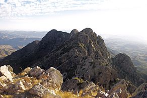
View of other three peaks from Browns Peak
-
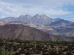
View from desert floor of Four Peaks


Four Peaks Wilderness Area
The Four Peaks Wilderness was created in 1984. It covers a large area of 60,740 acres (24,580 hectares). This wilderness is home to many different kinds of plants and animals. This is because the elevation changes quickly across the area.
Wildlife and Trails
Brown's Trail is a path found in the Four Peaks Wilderness. This trail leads to the tallest peak, Brown's Peak. Along this trail, you might see various animals. These include black bears, ring-tailed cats, skunks, and coyotes.
A part of the Arizona Trail also runs through the Four Peaks Wilderness. This section is known for being one of the most challenging parts of the trail. It is not often maintained, making it a rugged adventure for hikers.
The Lone Fire
On April 27, 1996, a large wildfire started in the Four Peaks Wilderness. Two campers left a campfire burning without watching it. This caused the fire, which was named the Lone Fire. It burned over 61,000 acres (24,685 hectares) of land. The fire lasted for 11 days. Before the Rodeo–Chediski Fire in 2002, the Lone Fire was the largest wildfire ever recorded in Arizona.
