Franktown, Colorado facts for kids
Quick facts for kids
Franktown, Colorado
|
|
|---|---|

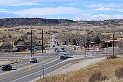
Franktown and the intersection of state highways 83 and 86.
|
|

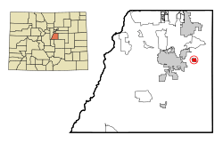
Location of the Franktown CDP in Douglas County, Colorado. Colorado
|
|
| Country | |
| State | |
| County | Douglas County |
| Government | |
| • Type | unincorporated community |
| Area | |
| • Total | 2.958 sq mi (7.661 km2) |
| • Land | 2.944 sq mi (7.625 km2) |
| • Water | 0.014 sq mi (0.036 km2) |
| Elevation | 6,197 ft (1,889 m) |
| Population
(2020)
|
|
| • Total | 409 |
| • Density | 138.27/sq mi (53.39/km2) |
| Time zone | UTC-7 (MST) |
| • Summer (DST) | UTC-6 (MDT) |
| ZIP Code |
80116
|
| Area codes | 303 & 720 |
| GNIS feature | Franktown CDP |
| Primary Highways | |
Franktown is a small community in Douglas County, Colorado, United States. It's considered an unincorporated town, which means it doesn't have its own city government like a big city would. It also has a post office and is known as a CDP, which is a special area defined for counting people.
Franktown is part of the larger Denver metropolitan area. The local post office uses the ZIP Code 80116. In 2020, about 409 people lived in Franktown.
Contents
History of Franktown
Franktown got its name from James Frank Gardner. He was a prospector who built a cabin in 1859, a few miles north of where Franktown is today. This area was first called Frankstown.
In 1861, the Territory of Colorado was created. Douglas County was formed, and Frankstown became its first county seat (the main town for county government). The post office from nearby Russellville moved to Frankstown in 1862.
Later, in 1864, the county seat moved to a place called California Ranch. This spot was a popular resting place on the busy Jimmy Camp Trail, which led north to Denver. People and the post office from Frankstown soon followed, and California Ranch became known as Franktown.
When the Denver & Rio Grande Railroad reached Colorado Springs in 1871, fewer people used the Jimmy Camp Trail. In 1874, Douglas County moved its county seat again, this time to Castle Rock, which was on the railroad.
Even though it lost the county seat, Franktown stayed an important place for ranching and farming. It had a church, a school, a grange (a farmers' group), and a few businesses. Franktown never officially became a city. For a long time, only about a hundred people lived there. Even as bigger towns grew around it, Franktown has kept its quiet, rural feel.
The Grange Movement
Franktown has always been a farming community, so it was a perfect fit for The Grange. This was a group for farmers that became popular across America in the 1870s. Many Grange chapters started in Colorado, including the Fonder Grange (1875) and later Pikes Peak Grange No. 163 (1908) in Franktown.
The Grange helped farmers by setting up things like credit unions and insurance. Local chapters held fun events like dances and picnics, and also town meetings. These activities helped people in spread-out communities feel more connected. Pikes Peak Grange No. 163 in Franktown is still active today and is listed on the National Register of Historic Places.
Castlewood Dam Collapse
The Castlewood Dam was built in 1890, about five miles south of Franktown on Cherry Creek. It held a lot of water to help water 30,000 acres of farmland. The dam started leaking the same year it was finished, and a large part of it even broke in 1897.
Even though people said the dam was strong, it kept leaking for many years. Finally, on August 3, 1933, the Castlewood Dam completely broke. A huge amount of water, like a billion gallons, rushed towards Denver. Only two people drowned because a phone operator made many calls to warn people. However, the flood destroyed farms in the area and washed away six bridges in Denver, which was thirty miles away. You can still visit the remains of the dam in nearby Castlewood Canyon State Park.
Timber Industry in the Pinery
Early travelers were happy when they reached the wooded area just south of Franktown. It was the first forest they saw after traveling hundreds of miles across the prairies. Settlers in Colorado also valued this forest as a source of wood for building.
This area was known as "the Pinery." It provided most of the lumber for fast-growing Denver and other towns in the 1860s. Many sawmills worked non-stop in and around Franktown, trying to keep up with the high demand for wood.
In the early 1870s, the Pinery also supplied wood for railroad ties to the Kansas Pacific and Denver & Rio Grande railroads. These railroads were building tracks within twenty-five miles of Franktown. These new rail lines eventually made it easier to get wood from larger forests, which led to the decline of the timber industry in this region. By 1880, Franktown's sawmills were quiet. However, the lumber from the Pinery had already helped build much of early Colorado.
Franktown Geography
Colorado State Highways 83 and 86 meet in the middle of Franktown. Highway 83 goes north about 9 miles to Parker and south about 45 miles to Colorado Springs. Highway 86 goes east about 9 miles to Elizabeth and west about 7 miles to Castle Rock, which is the main town for Douglas County.
The Franktown CDP covers an area of about 7.661 square kilometers (or 1,893 acres). A very small part of this area, about 0.036 square kilometers (9 acres), is water.
Population Changes
The United States Census Bureau first officially defined Franktown as a CDP for the United States Census 2000. Here's how the population has changed over the years:
- 2000: 99 people
- 2010: 395 people
- 2020: 409 people
Education
The Douglas County School District is responsible for the schools that serve the Franktown area.
See also
 In Spanish: Franktown (Colorado) para niños
 | Aurelia Browder |
 | Nannie Helen Burroughs |
 | Michelle Alexander |


