Fregata Island facts for kids

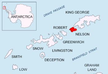
Location of Nelson Island in the South Shetland Islands
|
|
| Geography | |
|---|---|
| Location | Antarctica |
| Coordinates | 62°13′50″S 59°05′54″W / 62.23056°S 59.09833°W |
| Archipelago | South Shetland Islands |
| Length | 480 m (1,570 ft) |
| Width | 230 m (750 ft) |
| Administration | |
| Administered under the Antarctic Treaty System | |
| Demographics | |
| Population | uninhabited |
Fregata Island (which means "Frigate Island" in Bulgarian) is a small, rocky island found near the huge continent of Antarctica. It's located off the north coast of Nelson Island, which is part of the South Shetland Islands. These islands are a group of landmasses in the icy waters of the Southern Ocean.
This island is about 480 meters (1,575 feet) long from southeast to northwest. It's also about 230 meters (755 feet) wide. To give you an idea, that's roughly the length of five football fields! Fregata Island is not home to any people; it is completely uninhabited.
The island was named after a special ship. This ship was an ocean fishing trawler called Fregata. It belonged to a Bulgarian company named Ocean Fisheries – Burgas. Ships from this company were very active in the waters around South Georgia, Kerguelen, the South Orkney Islands, the South Shetland Islands, and the Antarctic Peninsula. They operated there from the 1970s until the early 1990s. These Bulgarian fishermen, along with those from the Soviet Union, Poland, and East Germany, were among the first to develop modern fishing in Antarctica.
Where is Fregata Island?
Fregata Island is located at 62°13′50″S 59°05′54″W / 62.23056°S 59.09833°W. It sits very close to other small islands and points of land. For example, it is:
- 2.29 kilometers (about 1.4 miles) west-northwest of Cariz Point
- 1.7 kilometers (about 1.05 miles) north-northeast of Baklan Point
- 1.93 kilometers (about 1.2 miles) east-northeast of Withem Island
- Only 110 meters (about 360 feet) northeast of Kondor Island
- Just 100 meters (about 328 feet) south-southwest of Akin Island
British explorers mapped this area in 1968, helping us understand where these small islands are.
 | James Van Der Zee |
 | Alma Thomas |
 | Ellis Wilson |
 | Margaret Taylor-Burroughs |


