Quick facts for kids
Kondor Island

|
Location in Antarctica
Show map of Antarctica
Location in Antarctic Peninsula
Show map of Antarctic Peninsula
|
| Geography |
| Location |
Antarctica |
| Coordinates |
62°13′58.4″S 59°06′02″W / 62.232889°S 59.10056°W / -62.232889; -59.10056 |
| Archipelago |
South Shetland Islands |
| Length |
320 m (1,050 ft) |
| Width |
140 m (460 ft) |
| Administration |
|
|
| Administered under the Antarctic Treaty System |
| Demographics |
| Population |
uninhabited |
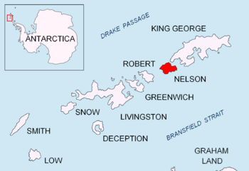
Kondor Island (Bulgarian: остров Кондор, romanized: ostrov Kondor) is a small, rocky island located just off the north coast of Nelson Island. It is part of the South Shetland Islands in Antarctica. This island is about 320 meters (1,050 feet) long from west to east and 140 meters (460 feet) wide.
Kondor Island gets its name from a special ship called the Kondor. This ship was a large fishing boat (a 'trawler') owned by a Bulgarian company. From the 1970s to the early 1990s, ships like the Kondor fished in the cold waters around places like South Georgia, Kerguelen, the South Orkney Islands, and the South Shetland Islands, including near the Antarctic Peninsula. Bulgarian fishermen, along with those from the Soviet Union, Poland, and East Germany, were among the first to develop modern fishing in Antarctica.
Where is Kondor Island?
Kondor Island is found at coordinates 62°13′58.4″S 59°06′02″W / 62.232889°S 59.10056°W / -62.232889; -59.10056. It is located about 2.45 kilometers (1.52 miles) west of Cariz Point. It is also 1.41 kilometers (0.88 miles) north-northeast of Baklan Point. Another nearby island is Withem Island, which is 1.73 kilometers (1.07 miles) to the east-northeast. Kondor Island is very close to Fregata Island, only about 110 meters (360 feet) to its southwest. The area around Kondor Island was mapped by British explorers in 1968.


