
Fremington Edge facts for kids


Fremington Edge is a long, rocky ridge in the Yorkshire Dales National Park in England. It's like a natural wall, about 3-mile (5 km) long, made of steep cliffs (called crags) and slopes covered in loose rocks (called scree). You can find it just north of the village of Reeth in an area known as Swaledale.
This impressive ridge marks the south-eastern edge of Arkengarthdale, stretching all the way to where Arkengarthdale meets Swaledale. Fremington Edge is always high up, staying above 1,300 feet (400 m) along its whole length. Its very highest point is 1,552 feet (473 m) at the northern end of the ridge.
Contents
What is Fremington Edge?
Fremington Edge is a striking natural feature. It's a long, steep slope or cliff that stands out in the landscape. The word "edge" here means a ridge or a high, sharp line of land. It's a popular spot for people who enjoy walking and exploring the outdoors.
How Fremington Edge Was Formed
Fremington Edge was created a very long time ago, after the last Ice age. During this time, huge sheets of ice called glaciers covered much of the land. As the climate warmed, these glaciers began to melt. The melting water caused a large landslip, which is when a mass of earth or rock slides down a slope. This landslip uncovered the rocky parts of the ridge that we see today.
Ancient History and Mining
People have lived near Fremington Edge for a very long time. There is proof of an Iron Age fort on the ridge, which means people lived there even before the 8th century when the Anglo-Saxons arrived.
The area around Fremington Edge was also important for mining. You can still see signs of old lead and chert mines scattered across the ridge. There are many old mine shafts (holes going into the ground) and piles of waste rock (called spoil heaps). The chert, a type of hard rock, was taken by trucks to Staffordshire. It was used there to make china and porcelain, which are materials for dishes and decorative items.
Exploring Fremington Edge
A walking path and a strong dry stone wall run along the entire length of Fremington Edge. To the east, you can see the wide, open land of Marrick Moor, covered in purple heather. About halfway along the ridge, you might notice the remains of an old radio mast that is no longer used.
How to Climb the Edge
You can start your climb up Fremington Edge from a few different places:
- From Reeth
- From Langthwaite
- From Fremington
Climbing from Langthwaite
If you start from Langthwaite, you'll follow an old lane. This lane passes a small group of houses called Booze and an old farmhouse called Storthwaite Hall. The path then winds steeply upwards through the old workings of the Fell End Lead Mine. This route takes you right to the highest point of the ridge.
Climbing from Fremington
From Fremington, you can use an old road that is now a stony track. This track is not too steep and leads towards Hurst. Along the way, you'll pass a white farmhouse called the White House. This house is easy to spot from Reeth and is a well-known landmark.
Climbing from Reeth
The climb from the popular village of Reeth can be quite challenging because it's very steep. A path goes directly up the escarpment from Arkle Beck to reach the top of the Edge.
Amazing Views from the Top
When you reach the top of Fremington Edge, you'll be rewarded with fantastic views.
- From the stone pile (cairn) at the northern end, you get an excellent view of Arkengarthdale. You can also clearly see Calver Hill from here.
- From the southern end of the Edge, you'll have an impressive view looking down over the village of Reeth.
Images for kids
-
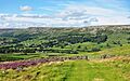
Fremington Edge as seen from Cogden Moor
-
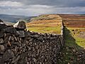
View from the eastern summit of Fremington Edge to the north-west into Arkengarthdale
