
Arkengarthdale facts for kids

Arkengarthdale is a beautiful valley, or "dale," located in North Yorkshire, England. It's on the eastern side of the Pennines mountains. The valley follows the Arkle Beck river and is the most northern of the famous Yorkshire Dales. Arkengarthdale joins a larger valley called Swaledale at a village called Reeth. You can learn all about the history of the dale, its people, farming, lead mining, and local crafts at the Swaledale Museum in Reeth.
As you travel up the dale from Reeth, the road crosses many small streams. You'll pass through tiny villages like Raw, Arkle Town, Langthwaite, Eskeleth, and Whaw. From Langthwaite, a small road leads to a village called Booze.
Near Eskeleth Bridge, another road branches off towards Barnard Castle. This road also connects to a smaller road along the northern side of the dale, leading to Whaw. Beyond Whaw, the valley becomes very quiet and wild. This area is one of the most northern parts of the Yorkshire Dales National Park. Eventually, the road reaches the Tan Hill Inn, which is the highest pub in England! It's just outside the National Park, close to the main watershed of the Pennines.
From Tan Hill, roads lead to other places like Brough, Keld, and Kirkby Stephen.
The open moorlands on both sides of Arkengarthdale are used for the annual Scott Trial. This is a challenging cross-country motorcycle race.
This valley sits in a major lead mining area. People dug for lead here for over a thousand years! Most of the old mining buildings are gone now. You can still see the piles of waste rock (called spoil heaps) and the path of a long chimney. This chimney, about 1,100 meters (3,600 feet) long, carried smoke from the old smelting mill.
Today, the main ways people make a living in Arkengarthdale are hill farming, grouse shooting, and tourism. In 1989, Arkengarthdale (and Swaledale) became a special "Barns and Walls Conservation Area." This means the traditional stone barns and walls are protected.
Contents
A Look at the Past: People and Land
Early Settlers and Roman Times
In the 1800s, a lead block with the name Hadrian stamped on it was found near Hurst, east of the dale. This block has since been lost from the British Museum. However, old records show that the Romans used slaves from the Brigantes tribe to dig for lead near Richmond. This makes people think the Romans were mining lead in Arkengarthdale as far back as the 2nd century.
Many place names in the dale, like Fagger Gill, Kitley Hill, Langthwaite, and Whaw, sound like Viking names. This suggests that Vikings settled here in the 10th century, probably coming from the west. The name "Arkil" is a Viking name, which makes some people wonder if he was an important local leader.
Norman Conquest and Royal Forests
After the Normans took over England in the 11th century, a large part of North Yorkshire was given to Count Alan. He was related to William the Conqueror. Count Alan kept Arkengarthdale and nearby New Forest as a special hunting "forest." This area was protected by forest rangers. In the 1300s, there were eight gamekeepers working to stop people from hunting game in the dale without permission.
By the late 1200s, there were about 30 small homes in the area. But then, for over a hundred years, the population dropped. This was due to tough times, including the plague and wars with France.
Changing Owners and New Roads
By the end of the 1500s, the Earls of Richmond no longer existed, and Arkengarthdale went back to being owned by the King or Queen. The Crown tried to change the agreements for the 55 small farm tenants, which led to many arguments. In 1628, the Crown sold Arkengarthdale to the City of London to help pay off its debts. Then, in 1656, a man named Charles Bathurst bought the valley. He was Oliver Cromwell's doctor.
The Bathurst family owned the estate for four generations. In 1740, it was inherited by Charles's three great-granddaughters. Back then, married women couldn't own property, so the estate belonged to their husbands.
In 1770, a new main road, called a turnpike road, was opened. It went from Reeth to Brough via Tan Hill. This road made it much cheaper to move lead and coal from the mines. Carts could be used instead of pack-horses, which were much slower.
Between 1808 and 1811, a banker from London named George Brown bought all three parts of the estate. Before he died in 1814, Brown had rebuilt the local school and planned a new church. His sister and his second sister's husband, Rev John Gilpin, inherited the estate.
Growth and Decline in the 1800s
The early 1800s were a time of growth for Arkengarthdale. In 1801, 1186 people lived there. By 1811, the population had grown to 1529. In 1798, there were 34 miners and only 1 farmer. By 1820, there were 9 farmers, 5 innkeepers, 4 mining agents, 2 flour dealers, a church leader, a schoolmaster, a clog maker, a shoemaker, and a shopkeeper. In 1831, 285 men over 25 worked as miners.
However, the price of lead dropped a lot, from £33 a ton in 1801 to £13 10s in 1831. This led to hard times, and many people left the dale to find work. Some went to factories in Derbyshire and Lancashire, others to mines in County Durham. Many also moved to America.
Between 1835 and 1841, the average age of death for miners was 54 years and 5 months. A disease called Typhus was also common in the dale.
Life in 1851
The 1851 census counted 1283 people living in Arkengarthdale. For 1073 of them, it was their birthplace. There were 659 males, and 254 of them were lead miners. Another 42 men worked in smelting (processing lead), construction, and transport. 18 women and children helped wash the lead ore. There were 7 coal miners living in William Gill. 49 farms employed 64 men and women. Among the many jobs listed, there were four dressmakers, one knitter, and one tailor. 51 out of 294 boys under 15, and 40 out of 247 girls, were attending school.
After the main mining company, CB Mining, closed in 1883, most miners left to find work. By 1891, the population of the dale had fallen to 761.
Modern Times
37 men from Arkengarthdale fought in the First World War, and three of them sadly died.
In 1921, someone in the dale owned a car for the first time. It was a Ford.
The estate stayed in the Brown-Gilpin family until it was sold to Tommy Sopwith after the First World War. Today, the shooting estate is shared between the Duke of Norfolk and a group from the Netherlands.
Lead Mining in Arkengarthdale
Lead is found in veins (cracks) that run through the large layers of limestone and chert rock in the area.
Old Mining Methods
One of the oldest ways to get lead ore was called "hushing". This involved building a dam to collect water. Then, the water was suddenly released along a vein where lead was thought to be. The powerful rush of water would wash away the topsoil, making the lead vein easier to dig. The Roman historian Pliny wrote about this method being used in Britain to get lead. You can still see good examples of these "hushes" in Arkengarthdale, along with signs of old dams and water channels.
Another early method was digging "bell pits". These were like deep wells with tunnels (called drifts) branching out sideways to follow the lead vein. Miners would keep extending these tunnels until they became unsafe. Then, they would dig another pit further along the vein. You can still see lines of these old pits across the moors.
The earliest written record of lead being taken from the dale is from 1285. It says that the "Lord's mine" made a profit of £4, possibly referring to a place called Faggergill. This was apart from the Roman lead block found earlier.
By 1521, a lot of mining was happening in Arkengarthdale, in areas like Moulds, Punchard Gill, and Faggergill.
Bell pits were common in the 1600s and 1700s. The lead was sold to merchants in York. Around 1700, gunpowder started to be used in mining, and by 1750, it was common. This allowed miners to dig deep tunnels into the hillsides. By the late 1800s, you could enter the Moulds Level in Arkengarthdale and travel six miles underground to the Sir Frances Mine in Gunnerside Gill, in the next valley.
The special six-sided powder house, used for storing gunpowder, was built in 1725.
In 1750, the Moulds Level, northwest of Langthwaite, was worked out (meaning all the lead was gone). It was later used to transport ore from other mines. It had its own smelting mill, but this was taken down after a new, octagonal mill was built.
The CB Company and Later Mines
Lead mining in Arkengarthdale was mostly controlled by the CB (Charles Bathurst) Company. This company started in 1656 when Dr. Bathurst bought the right to mine in the area from the Crown. His company continued until 1911, when the lead mining industry in Yorkshire collapsed because lead prices dropped too low.
Water was always a big problem in the mines. In the 1700s, a group of miners blasting underground near Boldershaw accidentally broke into an underground lake. Twenty-four miners and two pit ponies drowned in the flood that followed. In 1820, miners in Little Punchard Gill supposedly created a "canal level." This was a water channel where ore and waste could be floated to the surface. However, some modern researchers question if this canal really existed.
The Octagonal and New Mills

In 1800, the Arkengarthdale mines were leased for 21 years to a company from Newcastle. This company, led by Frederick Hall, invested a lot of money in new mining technology.
In 1804, they built a new smelting mill, about 2 miles north of Langthwaite. It was shaped like an octagon (eight sides), measuring 170 feet by 70 feet. It had a large 36-foot wide water wheel to power the bellows (which blew air into the furnaces). It also had four flues (chimneys) and a timber roof.
In 1824, the octagonal mill was replaced by the New Mill. This was built a few hundred yards away, on the other side of the Tan Hill road. The New Mill had a better furnace design and a 33-foot water wheel. It used the same long chimney that ran half a mile up to the top of the moor. This chimney was so large that men could climb inside to scrape off the lead that had condensed (turned solid) on the walls. It also helped to release the toxic fumes away from animals and plants.
The Octagonal Mill was then used as a saw mill. In 1941, part of its roof collapsed, and the rest was taken down. Today, you can only see the clear area where it once stood. Some parts of the walls from the New Mill can still be seen from the Tan Hill road. The New Mill closed in 1883. The path of its collapsed double chimney up the moor is still easy to see. The old powder house is still standing and was once used for making candles. People believed that an octagon shape was good for containing explosions.
In 1870, there was a strike at the Faggergill Mine. The new managers wanted the morning shift to start at a fixed time, which the miners didn't like. After an eight-week stoppage, the miners had to accept the changes.
The last lead mining company in the Dale was Stang and Cleasby Mines, started in 1908. They dug the Nuthole Mine, which connected to the Faggergill Levels. They managed to make a small profit until 1914. They created a mile-long horse level, which was a tunnel wide enough for horses to pull carts through. The Faggergill levels are thought to be about fifteen miles long in total. The mine was sold in 1912 and continued to make a small profit until the First World War.
Other minerals were also mined in the Dale, but on a smaller scale. Coal was dug in Punchard Gill until the 1940s. Chert (a type of rock) was taken from the Hungry Hushes and along Fremington Edge, also stopping after 1940.
Villages and Parishes
- Arkle Town
- Booze
- Eskeleth
- Langthwaite
- Whaw
Arkengarthdale is also a civil parish (a local government area) in the Richmondshire district of North Yorkshire. This parish covers most of the valley. In the 2011 census, 231 people lived in this civil parish.
The lowest part of the dale, including the small village of Raw, is part of the civil parish of Reeth, Fremington and Healaugh.
Images for kids
-
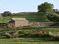
Traditional stone barns and dry stone walls on the outskirts of Reeth in lower Arkengarthdale
-

Traditional stone barn with outshut and livestock enclosure between Arkle Gill and Punchard Beck, about 2 km (1.2 mi) north-west of Langthwaite
-
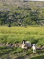
Sheep and lamb in lower Arkengarthdale with Fremington Edge in background
-
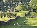
Sheep grazing in lower Arkengarthdale with Fremington Edge in background
-
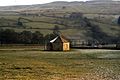
Powder house used for storing gunpowder for CB lead mines. Built in 1725.
-
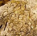
Hungry Hushes: Graffiti "J.Alcock 1828". Coin 22mm.
-
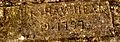
Inscription on moors above Black Hills. "Wet Shaw Head Ap 19 + 1797". Unknown significance.


