
Fusagasugá facts for kids
Quick facts for kids
Fusagasugá
|
|||
|---|---|---|---|
|
Municipality and city
|
|||

Palmas Avenue, Center
|
|||
|
|||
| Nickname(s):
The Garden City of Colombia
|
|||
| Motto(s):
Tierra Grata Pleasing Earth
|
|||

Location of the town and municipality of Fusagasugá in Cundinamarca Department.
|
|||

Fusagasugá
Location in Colombia
|
|||
| Country | Colombia | ||
| Region | Andean Region | ||
| Department | Cundinamarca | ||
| Province | Sumapaz Province | ||
| Established as Town for Natives | February 5–13, 1592 | ||
| Established as Town for Whites | May 7, 1776 | ||
| Government | |||
| • Type | Municipality | ||
| Area | |||
| • Municipality and city | 193.9 km2 (74.9 sq mi) | ||
| • Urban | 14.42 km2 (5.57 sq mi) | ||
| • Rural | 179.48 km2 (69.30 sq mi) | ||
| Elevation | 1,765 m (5,791 ft) | ||
| Highest elevation | 3,050 m (10,010 ft) | ||
| Lowest elevation | 550 m (1,800 ft) | ||
| Population
(2018 census)
|
|||
| • Municipality and city | 138,498 | ||
| • Density | 714.28/km2 (1,850.0/sq mi) | ||
| • Urban | 114,722 | ||
| • Urban density | 7,955.8/km2 (20,605/sq mi) | ||
| • Rural | 23,776 | ||
| • Rural density | 132.472/km2 (343.100/sq mi) | ||
| Demonym(s) | fusagasugueño | ||
| Area code(s) | 57 + 1 | ||
.svg)

Fusagasugá (pronounced fusa-ga-soo-GAH), often called Fusa, is a city and municipality in the Cundinamarca department of central Colombia. It sits in a warm valley between the Cuja and Panches rivers. This area is part of the Andes Mountains in South America.
The city was founded in 1592 by Spanish priests. It is about 56 kilometers (35 miles) from Bogotá, the capital of Colombia. Fusagasugá is surrounded by other towns like Pasca, Arbeláez, Tibacuy, and Silvania. The city is about 1,728 meters (5,669 feet) above sea level. Its average temperature is around 20°C (68°F).
Contents
What's in a Name?
The name Fusagasugá comes from an old language. It can mean "Woman who becomes invisible" or "Woman who hides behind the mountain." Many people simply call it "Fusa" for short.
The city is also known as "Tierra Grata," which means "Pleasing Earth." This name comes from the many farms and country homes in the area. It's also called "The Garden City of Colombia" because it's famous for growing beautiful Orchids.
A Look at History
Early Days
The Sutagao people lived in this region long before the Spanish arrived. A Spanish official named Oídor Bernardino Albornoz officially founded the new town between February 5 and 13, 1592. Not much is known about the daily lives of the native people before this time.
In 1592, about 759 indigenous people lived in Fusagasugá. By 1760, this number had dropped to 85. At the same time, 644 new settlers, or non-native families, had moved into the area. In 1760, a small hospital was built near the church.
Growing as a City
As the number of native people decreased and new settlers grew, officials decided to change things. In 1776, they combined the native villages of Fusagasugá, Pandi, and Tibacuy into the city of Pasca. All the streets and town squares were renamed.
In 1771, a new main road called Santafé Avenue was ordered to be built. It would connect Fusagasugá with nearby Sibaté. By 1774, Fusagasugá was on an important road that linked it to other towns like Apicalá and Melgar. This made Fusagasugá a key stop for travelers.
In 1846, the president of Colombia recognized the road from Fusagasugá to the southern provinces as important. This led to the building of a road over the Sumapaz River. In 1852, Fusagasugá became part of the Tequendama province.
Important Events
A battle took place in 1877 at a farm called El Novillero. Government forces fought against rebels there. In 1893, the first hospital was built with money from generous donors.
Fusagasugá became the capital of Sumapaz Province in 1895. This showed its growing importance in the region.
A major highway project connecting Sibaté, Fusagasugá, and Boquerón began in 1893. It was stopped for a while due to conflict but restarted and finally reached Fusagasugá in 1930. A new bridge over the Sumapaz River was finished in 1907. It was first used by cars in 1930 and replaced with a new one in 1953.
The city's main church has been rebuilt many times. The first church was built in 1658. The current church was started in 1909 and finished in 1926.
During World War II, a hotel in Fusagasugá was used as a camp for people from countries that were at war with Colombia.
Where is Fusagasugá?
Climate and Weather
Fusagasugá is located between 550 meters (1,804 feet) and 3,050 meters (10,000 feet) above sea level. The average height is about 1,728 meters (5,669 feet). The average temperature is around 19°C (66°F).
The air in Fusagasugá is usually quite humid, about 85% on average. The wind speed changes throughout the day, being strongest around midday.
Fusagasugá gets a lot of rain, especially in March, April, May, October, November, and December. The drier months are January, February, June, July, August, and September. The city gets about 1,560 hours of sunshine each year.
| Weather chart for Fusagasugá, Valsalice | |||||||||||||||||||||||||||||||||||||||||||||||
|---|---|---|---|---|---|---|---|---|---|---|---|---|---|---|---|---|---|---|---|---|---|---|---|---|---|---|---|---|---|---|---|---|---|---|---|---|---|---|---|---|---|---|---|---|---|---|---|
| J | F | M | A | M | J | J | A | S | O | N | D | ||||||||||||||||||||||||||||||||||||
|
121
25
15
|
110
25
16
|
155
25
16
|
139
25
16
|
149
24
16
|
74
24
16
|
52
24
16
|
44
25
16
|
94
25
16
|
147
24
16
|
158
24
16
|
130
24
16
|
||||||||||||||||||||||||||||||||||||
| temperatures in °C precipitation totals in mm source: IDEAM Weather |
|||||||||||||||||||||||||||||||||||||||||||||||
|
Imperial conversion
|
|||||||||||||||||||||||||||||||||||||||||||||||
| Climate data for Fusagasugá/Tibacuy (Tibacuy Gja), elevation 1,550 m (5,090 ft), (1971–2000) | |||||||||||||
|---|---|---|---|---|---|---|---|---|---|---|---|---|---|
| Month | Jan | Feb | Mar | Apr | May | Jun | Jul | Aug | Sep | Oct | Nov | Dec | Year |
| Mean daily maximum °C (°F) | 24.4 (75.9) |
24.2 (75.6) |
24.0 (75.2) |
23.6 (74.5) |
23.5 (74.3) |
23.7 (74.7) |
24.1 (75.4) |
24.6 (76.3) |
24.4 (75.9) |
23.4 (74.1) |
23.0 (73.4) |
23.4 (74.1) |
23.8 (74.8) |
| Daily mean °C (°F) | 19.6 (67.3) |
19.5 (67.1) |
19.5 (67.1) |
19.3 (66.7) |
19.2 (66.6) |
19.1 (66.4) |
19.2 (66.6) |
19.5 (67.1) |
19.6 (67.3) |
19.1 (66.4) |
18.9 (66.0) |
18.9 (66.0) |
19.3 (66.7) |
| Mean daily minimum °C (°F) | 15.3 (59.5) |
15.3 (59.5) |
15.7 (60.3) |
15.7 (60.3) |
15.6 (60.1) |
15.3 (59.5) |
14.9 (58.8) |
15.2 (59.4) |
15.3 (59.5) |
15.3 (59.5) |
15.2 (59.4) |
15.0 (59.0) |
15.3 (59.5) |
| Average precipitation mm (inches) | 77.3 (3.04) |
88.2 (3.47) |
124.5 (4.90) |
120.9 (4.76) |
89.0 (3.50) |
50.2 (1.98) |
38.2 (1.50) |
39.7 (1.56) |
67.9 (2.67) |
128.0 (5.04) |
145.7 (5.74) |
94.9 (3.74) |
1,064.5 (41.91) |
| Average precipitation days | 10 | 12 | 15 | 16 | 17 | 14 | 13 | 13 | 15 | 19 | 18 | 12 | 172 |
| Average relative humidity (%) | 78 | 79 | 80 | 82 | 83 | 79 | 75 | 73 | 73 | 79 | 83 | 80 | 79 |
| Mean monthly sunshine hours | 161.2 | 124.4 | 114.7 | 102.0 | 114.7 | 120.0 | 133.3 | 124.0 | 123.0 | 120.9 | 117.0 | 158.1 | 1,513.3 |
| Mean daily sunshine hours | 5.2 | 4.4 | 3.7 | 3.4 | 3.7 | 4.0 | 4.3 | 4.0 | 4.1 | 3.9 | 3.9 | 5.1 | 4.1 |
| Source: Instituto de Hidrologia Meteorologia y Estudios Ambientales | |||||||||||||
| Climate data for Fusagasugá, ITA Valsalice, elevation 1,460 m (4,790 ft) in the rural area 1981–2010 normals, | |||||||||||||
|---|---|---|---|---|---|---|---|---|---|---|---|---|---|
| Month | Jan | Feb | Mar | Apr | May | Jun | Jul | Aug | Sep | Oct | Nov | Dec | Year |
| Mean daily maximum °C (°F) | 25.3 (77.5) |
25.4 (77.7) |
25.1 (77.2) |
24.6 (76.3) |
24.3 (75.7) |
24.1 (75.4) |
24.4 (75.9) |
25.1 (77.2) |
24.9 (76.8) |
24.4 (75.9) |
24.1 (75.4) |
24.4 (75.9) |
24.7 (76.5) |
| Daily mean °C (°F) | 20.6 (69.1) |
20.7 (69.3) |
20.4 (68.7) |
20.3 (68.5) |
20.2 (68.4) |
20.0 (68.0) |
20.2 (68.4) |
20.5 (68.9) |
20.6 (69.1) |
20.6 (69.1) |
20.2 (68.4) |
20.3 (68.5) |
20.4 (68.7) |
| Mean daily minimum °C (°F) | 15.4 (59.7) |
15.9 (60.6) |
16.0 (60.8) |
16.1 (61.0) |
15.9 (60.6) |
15.6 (60.1) |
15.5 (59.9) |
15.7 (60.3) |
15.7 (60.3) |
15.6 (60.1) |
15.5 (59.9) |
15.5 (59.9) |
15.7 (60.3) |
| Average precipitation mm (inches) | 121.3 (4.78) |
109.8 (4.32) |
154.9 (6.10) |
138.6 (5.46) |
148.5 (5.85) |
73.8 (2.91) |
51.8 (2.04) |
43.7 (1.72) |
93.8 (3.69) |
147.1 (5.79) |
157.5 (6.20) |
130.3 (5.13) |
1,332.6 (52.46) |
| Average rainy days | 13 | 13 | 16 | 19 | 20 | 17 | 17 | 13 | 16 | 19 | 19 | 14 | 191 |
| Average relative humidity (%) | 78 | 78 | 82 | 83 | 83 | 81 | 80 | 77 | 76 | 79 | 81 | 82 | 80 |
| Mean daily sunshine hours | 5.9 | 5.2 | 4.2 | 3.8 | 3.7 | 4.1 | 4.3 | 4.5 | 4.5 | 4.7 | 4.7 | 5.1 | 4.6 |
| Source: Instituto de Hidrologia Meteorologia y Estudios Ambientales | |||||||||||||
| Climate data for Fusagasugá, El Pinar, elevation 1,900 m (6,200 ft) in the rural area 1981–2010 normals, | |||||||||||||
|---|---|---|---|---|---|---|---|---|---|---|---|---|---|
| Month | Jan | Feb | Mar | Apr | May | Jun | Jul | Aug | Sep | Oct | Nov | Dec | Year |
| Average precipitation mm (inches) | 143.1 (5.63) |
127.3 (5.01) |
188.7 (7.43) |
195.6 (7.70) |
156.1 (6.15) |
79.6 (3.13) |
77.3 (3.04) |
63.8 (2.51) |
93.5 (3.68) |
208.4 (8.20) |
212.4 (8.36) |
144.0 (5.67) |
1,689.8 (66.53) |
| Average rainy days | 13 | 13 | 17 | 20 | 21 | 19 | 19 | 18 | 17 | 21 | 20 | 16 | 212 |
| Source: Instituto de Hidrologia Meteorologia y Estudios Ambientales | |||||||||||||
Where is Fusagasugá Located?
Fusagasugá is an important hub for travel in Colombia. It connects many cities and regions.
 |
Silvania, Medellín | Silvania, Granada | Bogotá, Sibaté | |
| Tibacuy, Chocho River, Panches River, Ibagué | Pasca, Sumapaz (Bogotá) | |||
| Melgar, Girardot, Sumapaz River, Cali | Arbelaez, Guavio River, Cuja River | Sumapaz National Park |
The city gets its water from a local company called Emserfusa.
How Many People Live Here?
Fusagasugá has grown a lot in population. This is because of its nice climate and its location close to Bogotá.
In 2005, about 107,259 people lived in the municipality. About 85,008 lived in the city area, and 22,251 lived in the countryside. By 2018, the total population had grown to 138,498.
| Population census | ||
|---|---|---|
| Year | Pop. | ±% p.a. |
| 1987E | 63,886 | — |
| 1993C | 82,003 | +4.25% |
| 2005C | 108,949 | +2.40% |
| 2015E | 134,523 | +2.13% |
| 2020E | 154,423 | +2.80% |
| Note: Municipality 193.9 km2 | ||
| Population census | ||
|---|---|---|
| Year | Pop. | ±% p.a. |
| 1985C | 41,571 | — |
| 1993C | 57,915 | +4.23% |
| 2005C | 86,878 | +3.44% |
| 2018C | 114,722 | +2.16% |
| Note: Urban town 14.4 km2 | ||
Most people in Fusagasugá are Christian.
How the City is Organized
Fusagasugá is divided into 6 urban areas called communes and 5 rural areas called townships. These are further broken down into smaller neighborhoods and rural districts. The total area of the municipality is about 206 square kilometers (79 square miles). About 13 square kilometers (5 square miles) are urban, and 191 square kilometers (74 square miles) are rural.
City Communes
| Population distribution by Urban | |||
|---|---|---|---|
| Centro | 12,985 | (13.87%) | |
| Norte | 18,612 | (19.88%) | |
| Oriental | 15,059 | (16.09%) | |
| Occidental | 14,482 | (15.47%) | |
| Sur Oriental | 17,670 | (18.88%) | |
| Sur Occidental | 14,806 | (15.82%) | |
The urban area has many neighborhoods. Here are the main communes and their populations:
- Centro: This commune covers about 0.63 square kilometers (0.24 square miles) and has 12,985 people.
- Norte: This area is about 1.48 square kilometers (0.57 square miles) and has 18,612 people.
- Oriental: This commune is about 1.54 square kilometers (0.59 square miles) and has 15,059 people.
- Occidental: This is the largest urban commune at 4.08 square kilometers (1.58 square miles) with 14,482 people.
- Sur Oriental: This area is about 1.49 square kilometers (0.58 square miles) and has 17,670 people.
- Sur Occidental: This commune is about 3.81 square kilometers (1.47 square miles) and has 14,806 people.
| Commune | Population | Area (km2) |
Density (/km2) |
|---|---|---|---|
| Centro | 20,610/km2 | ||
| Norte | 12,580/km2 | ||
| Oriental | 9,780/km2 | ||
| Occidental | 3,550/km2 | ||
| Sur Oriental | 11,860/km2 | ||
| Sur Occidental | 3,886/km2 |
Countryside Divisions
| Population distribution by Rural | |||
|---|---|---|---|
| Norte | 4,608 | (16.50%) | |
| Oriental | 3,060 | (10.96%) | |
| Suroriental | 6,976 | (24.98%) | |
| Suroccidental | 8,690 | (31.12%) | |
| Occidental | 4,587 | (16.43%) | |
The rural area is divided into 5 main districts and 38 smaller sub-districts. It covers about 191 square kilometers (74 square miles).
- Norte: This rural area is about 34.79 square kilometers (13.43 square miles).
- Oriental: This area is about 17.94 square kilometers (6.93 square miles).
- Sur Oriental: This is the largest rural area at 59.91 square kilometers (23.13 square miles).
- Sur Occidental: This area is about 48.76 square kilometers (18.83 square miles).
- Occidental: This rural area is about 29.59 square kilometers (11.42 square miles).
| Commune | Population | Area (km2) |
Density (/km2) |
|---|---|---|---|
| Norte | 132.45/km2 | ||
| Oriental | 170.6/km2 | ||
| Sur Oriental | 116.441/km2 | ||
| Sur Occidental | 178.22/km2 | ||
| Occidental | 155.02/km2 |
Fusagasugá's Economy
In 2007, Fusagasugá was the tenth most important economy in its department. Its economy mainly relies on farming and construction. However, the service industry is growing fast. This includes education, health, fun activities, and tourism. The local government also supports new farming technologies.
| Altagracia | Spanish Neighbors | Natives |
|---|---|---|
| 1580 (Foundation) | 14 | 790 |
| 1776 (Extinction) | 988 | 78 |
| Fusagasugá | Population | Budget |
|---|---|---|
| 1776 (Founded) | 60 | - |
| 1918 | 18,856 | - |
| 1955 | 27,000 | 1,105,000 |
| 1987 | 56,536 | 199,852,200 |
| 2015 | 134,523 | 117,124,852,662 |
| Source: DANE | ||
Education in Fusagasugá
In 2003, Fusagasugá had 97 schools. About 68% were public schools, and 32% were private. Most schools (54) were in the city, while 43 were in rural areas.
The city is home to several universities and educational centers. These include the Universidad de Cundinamarca, the School of Public Service ESAP, and the Police School. There are also other institutions like SENA, which offers technical training.
Fun Things to Do
Fusagasugá's warm climate makes it a popular place for tourists. You can find many hotels, resorts, and swimming pool parks here. The Pan-American highway passes through Fusagasugá. This means if you want to travel to cities like Ibagué or Cali from the north, you'll pass through Fusagasugá.
Along the highway, you can see many greenhouses with plants and flowers. There are also stores selling handmade wooden furniture and local restaurants where you can try delicious food.
Sports in Fusagasugá
Fusagasugá used to have a soccer team called Expreso Rojo. They played in Colombia's second division. Cycling is also a very popular sport in Fusagasugá. In recent years, roller-skating has become very popular, especially among kids.
Famous People from Fusagasugá
- Julio César Cadena, a former professional cyclist
- Víctor Hugo González, a former professional cyclist
- Pablo Wilches, a former professional cyclist
- Luis Herrera, a former professional cyclist
Images for kids
-
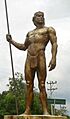
Sculpture of a Sutagao man at the entrance of Fusagasugá

See also
 In Spanish: Fusagasugá para niños
